Another snowstorm is upon us, which means it’s time for another live blog entry. Here, we continuously give updates on the storm throughout the day, whether it’s talking about the radar imagery, expected banding, short-range mesoscale model trends, general atmospheric conditions, or simply what one can expect at a given timeframe.
5:45pm Update: Heavy snow for much of the region continues, particularly for North-Central New Jersey through Southwest Connecticut. The cause of this is extremely impressive frontogenesis values, causing plenty of lift for heavy snow.

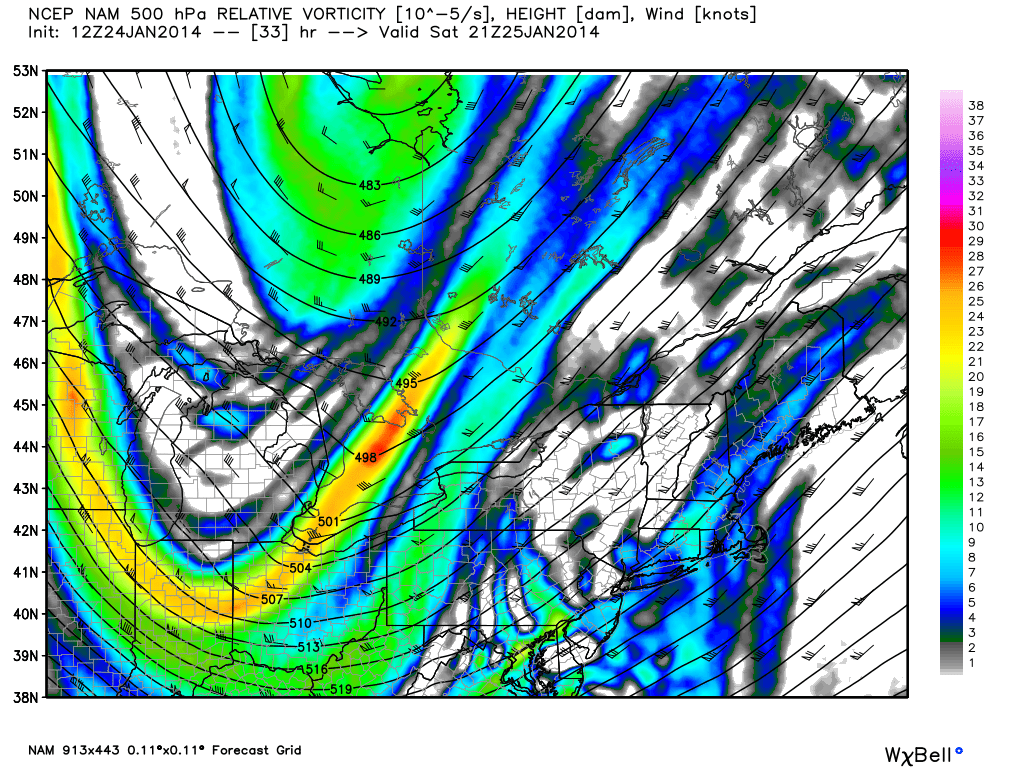
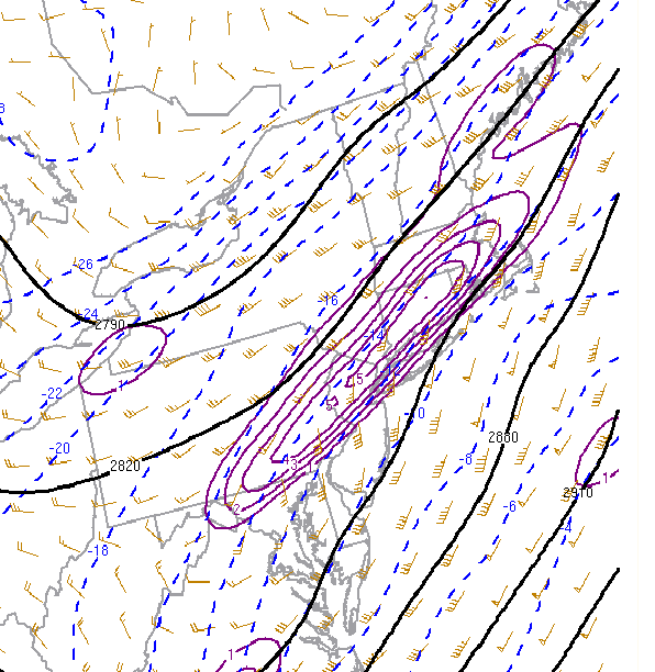
SPC Mesoanalysis shows very impressive values of 700mb frontogensis, just to the west, north, and northwest of NYC. This is where the heaviest snow is currently falling.
This explains the northward shift in the heavy band which was previously crushing Burlington and Monmouth Counties. Amounts in those areas are between 10-12″ in spots already! This band is continuing to have 1-3″ per hour snowfall rates.
As the storm moves and organizes more, those bands will begin to pivot, expand, and sink southward. Thus, the NYC area and Long Island will be back in the heavier snow pretty soon, after briefly having a lull. Thus, 1-3″ per hour rates can be expected once again, starting shortly. 10″+ amounts will be rather widespread.
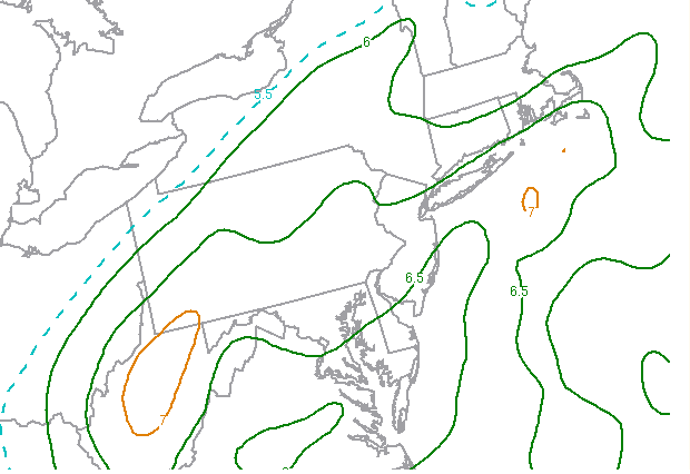
The possibility still exists for thundersnow, as well, in these heavier bands. All of the lift with the frontogenesis, combined with 6.5C/KM mid-level lapse rates generates instability, perhaps enough for some thunder.
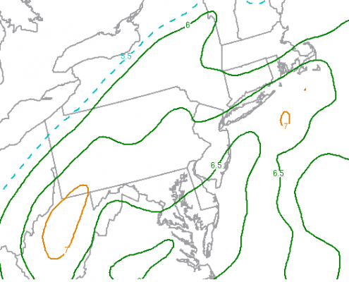
SPC Mesoanalysis shows mid-level lapse rates of around 6.5C/KM, which could support some thunder.
The best chance for any thunder will be within the next few hours.
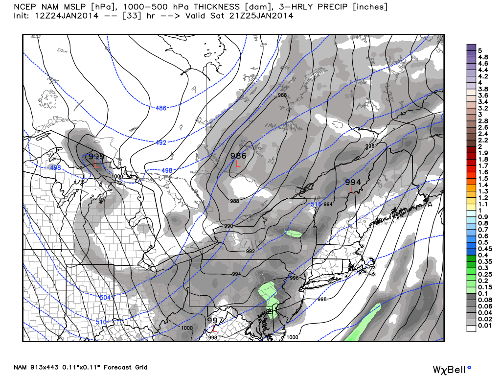
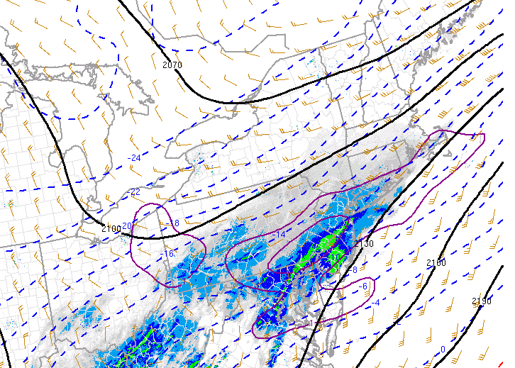
11:45am Update: Heavy band of snow continues to develop in New Jersey, as 850-700mb frontogenesis continues to increase. Frontogenesis is an increasing temperature gradient, which helps to lead to more lift. The heaviest band right now is in the Philly through Trenton and Monmouth County corridor, with moderate snowfall elsewhere to the north, and also heavy snow to the south of that heaviest band.

SPC Mesoanalysis shows the heaviest band of snow is aligned with the strongest 850-700mb frontogenesis (purple circles).
As the day goes on, frontogenesis is expected to strengthen, expand a bit, and move northeastward, as the storm does as well. This heavy band of 1-2″ per hour is expected to move into NYC and Long Island within the next hour or two. The banding may initially have a harder time reaching northern NJ areas.
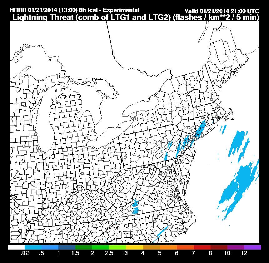
Additionally, the threat for thundersnow continues to be elevated. The latest HRRR model shows lightning strikes hitting the area at 4:00pm, which is the exact time the sounding we posted a while back was valid for — confirming the fact that everything still appears to be on track.

The HRRR model is showing lightning strikes in the blue shaded areas at 4:00pm, supporting thundersnow. 2-3″ per hour snowfall rates can often occur during thundersnow.
Needless to say, the evening commute will be quite the mess and very dangerous.
930am Update: All forecast products have been refreshed. The forecast remains generally unchanged but we have opted to expand our area of 8″+ potential to include NYC and points in Northeast NJ as well as much of Central NJ including the NJ Shore. The basic premise of what occurs today remains the same. Snow increases in intensity slowly between now and noon, and then eventually becomes steady and heavy throughout much of the area. Locally heavier snow in bands is expected essentially near I-95 and points South and East of there.
Within the heavy bands, very low visibility as well as rapid accumulation is possible. Forecast soundings continue to indicate steep lapse rates capable of producing thundersnow but forecasting this is nearly impossible over any specific area. The snow continues into the evening before becoming more light and wrapping up in the early morning hours on Wednesday. Our new snow forecast map is included below. Keep reading below that for a detailed breakdown on snow growth and lift in today’s system.
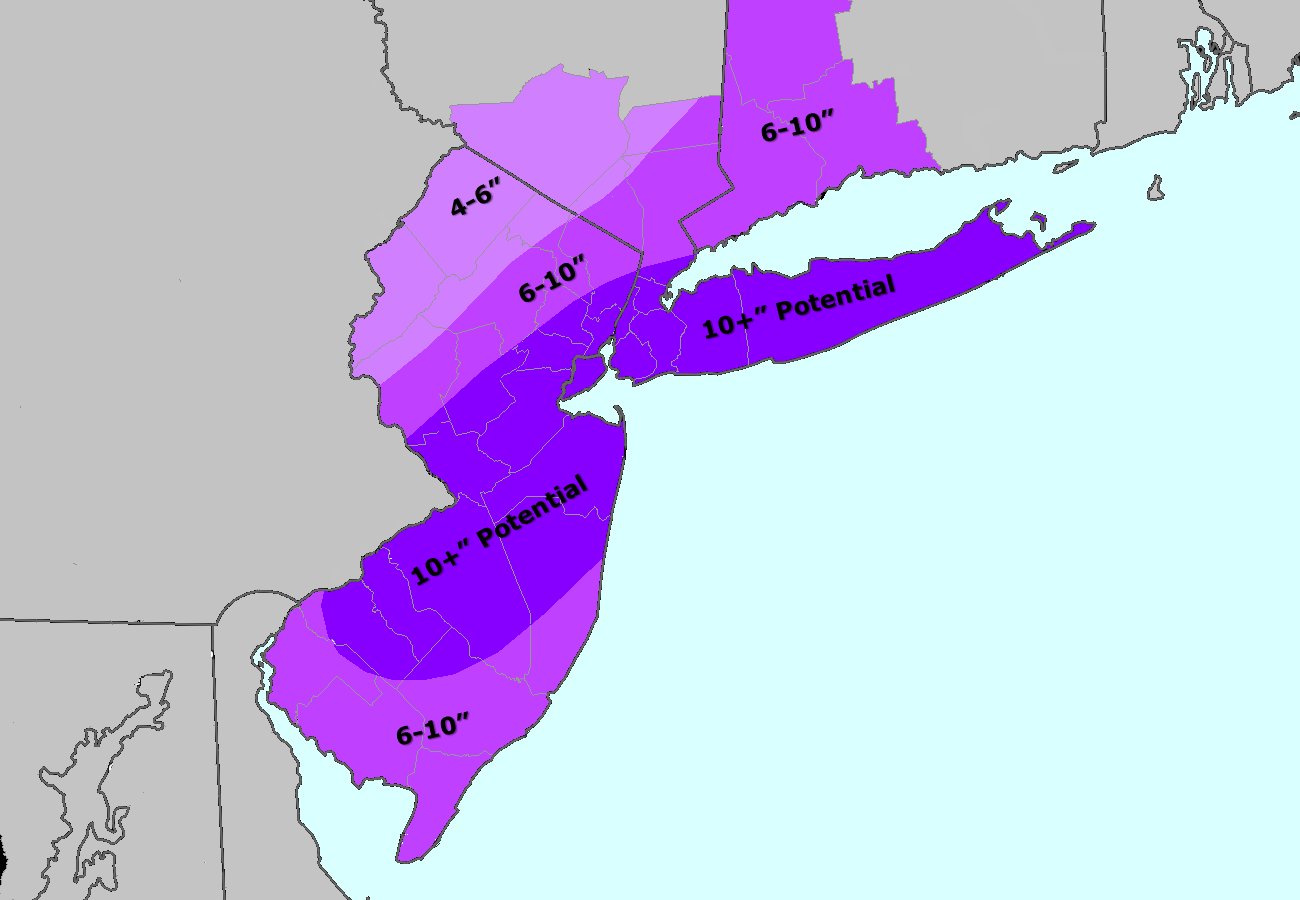
Our latest storm total snowfall forecast.
We’d like to start this blog post by discussing a bit about the snow ratios for this event, as well as the potential for heavy banding. One of the reasons why we have high confidence in a widespread 6″+ storm for the region, with many regions receiving 10″+, is the fact that the snow-to-liquid ratios will be much higher than 10:1. There are several factors that determine this:
1) The temperatures in the regions that the snowflakes are forming.
2) The maximum temperature in the atmospheric profile.
3) The amount of lifting in the regions that the snowflakes are forming.
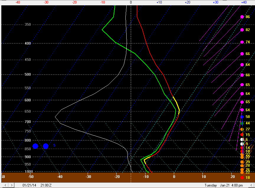
Let’s take a look at the forecast GFS sounding for JFK, valid at 4:00pm:

The GFS forecast model sounding for JFK valid for 4:00pm shows favorable conditions for high snowfall ratios, heavy banding, and perhaps even thundersnow.
As far as factor #1 is concerned, we can identify the snowgrowth region in the yellow line from approximately between 670mb and 580mb. The temperatures in that snowgrowth zone are exactly in between -12 and -18C, which is ideal for the formation of fluffy dendrites, which accumulate quite efficiently.
As far as factor #2 is concerned, the whole atmospheric profile is frigid! With the Janaury 3 event, snow ratios were good, but were not as great as they could have been, because of strong winds cutting into the snowflakes, as well as strong warm air advection a bit above the surface, which although did not impact the snow growth zone, did raise the maximum temperatures in the profile. If a snowflake is falling through a warmer atmosphere, it can become a bit wetter, and thus lose some of the fluff factor. If all other factors are extremely favorable, this is often not as important, but it still does play a roll somewhat.
As far as factor #3 is concerned, there is plenty of lift in the snow growth zone — more-so than what was observed in the January 3 event. Omega values are between -20 and -30 microbars per second, which is extremely impressive. All of this lift will lead to the quick, efficient formation of dendrites.
As a matter of fact, this sounding supports ratios between 20 and 25:1! We are not quite sure they will be that high throughout the storm, but an average snowfall ratio of 20:1 is certainly not out of the question, which is why many locations could definitely eclipse the 10″ mark.
Another important aspect of lifting is the fact that it leads to heavy precipitation in general. Unstable atmospheres tend to have more lift, and can even become convective. Sometimes, lift can be so strong, that thundersnow becomes possible. As one can see in this sounding, the lapse rates between 700mb and 500mb are around 7C/KM, which is often better than what we see here with summertime thunderstorms! Thus, it is possible that some areas in the heavy bands of snow will receive snowfall rates between 1-3″ per hour, with thunder as well.
Pinpointing the locations of these bands by the hour will be quite the task, but we will do our best to make sure we have that narrowed down for you as much as possible in this blog. Areas that stay under these bands a bit longer could easily exceed 10″, and may even end up with amounts as high as 14″. Areas that miss the bands and are in a zone of subsidence may only receive closer to 6″ of snow. Subsidence often forms in between bands; or, if there is no second band, on the west side of the band where the air is drier. This is because with all the extreme lift in the band, the atmosphere balances itself out by creating an area of downward vertical motion near-by, which limits precipitation production. As of now, we favor the heaviest banding to be along and SE of I-95; particularly in or near Monmouth and Ocean Counties, and perhaps in parts of Burlington County as well; as well as Long Island. We would not be surprised if some of this heaviest band shifted a bit further north. Areas that miss the banding may be near Sussex County.
That being said, we expect there to be more reports of 10″+ in our area than <6″.
-2")