-2")
Snow squalls tomorrow: 1-2″ of snow with brief whiteout conditions possible
Our cold and wintry pattern continues, as the Polar Vortex remains entrenched in Southeast Canada, providing bitterly cold air. It also is the source for mid-level disturbances, as lobes of vorticity rotate counterclockwise around it, and drop southward towards the United States. This disturbance won’t gain a whole lot of separation from the vortex, however, which will allow it to get reabsorbed back into the vortex during the day tomorrow. This leads to the storm taking a track north of our area, back into southeast Canada, with a strong cold front out ahead of it. It is this cold front that will help to spark instability for snow showers and snow squalls — similar to how cold fronts during the summer provide instability for scattered showers and thunderstorms with locally heavy downpours.
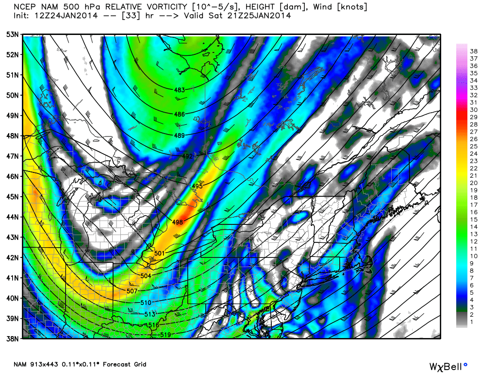
Today’s 12z NAM 500mb forecast heights and vorticity valid for 4:00pm tomorrow afternoon shows a mid-level disturbance rotating around the Polar Vortex, with some lobes or vorticity running out ahead of it in the Northeast. This will trigger some snow squalls. Image credit goes to weatherbell.com
The system looks pretty robust in the mid-levels of the atmosphere, but since the storm system is not going to dig all that far south, it will not be able to obtain a significant moisture feed. Thus, widespread heavy precipitation amounts are quite unlikely. However, this does not mean that localized heavy bands of snow will not occur. The potent mid-level disturbance will still be able to generate the lift necessary for locally heavy snow squalls.
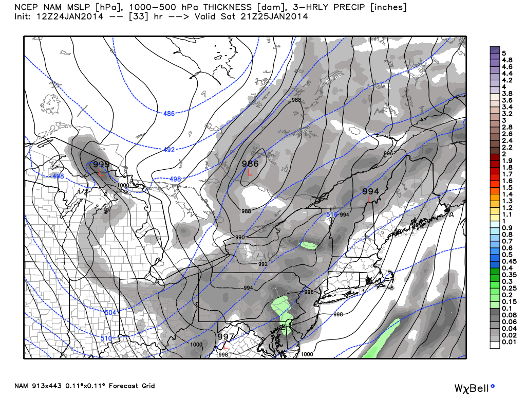
Today’s 12z NAM valid for 4:00pm tomorrow shows a 986mb low in SE Canada, a very unusual track for snow. Image credit goes to weatherbell.com
What results at the surface is a 986mb low pressure system in SE Canada, with seemingly lackluster moisture. What is interesting to note, however, is the fact that we are getting snow with a low pressure system going well to our northwest. This is quite unusual, since strong low pressure systems in SE Canada usually advect strong southerly winds into the area, which helps to warm our temperatures significantly. As previously mentioned, most of the precipitation will come out ahead of a cold front — being ahead of a cold front is the warm side of one, which usually means warm temperatures.
However, since the airmass we are in is so cold, the strong southerly and southwesterly winds will only warm temperatures into the upper 20s to around 30, instead of the usual well-above freezing values that we usually see. This is much more typical for a region like Canada, where warm air advection simply bumps temperatures up to around 30, instead of much warmer. By the time temperatures finally approach freezing, the Arctic cold front will be crossing the area, plummeting our temperatures right back into the ice box.
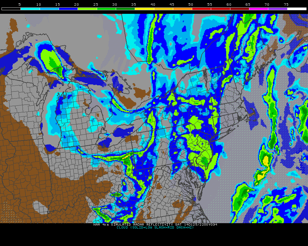
Today’s high-resolution NAM model shows a large snow squall moving into New Jersey at 5:00pm, with its eyes set on NYC.
Thus, as the cold front approaches the area, lift will be generated for snow showers and snow squalls, as shown in the model above. As of now, we feel that the best chance for amounts being >2″ locally will be in NW NJ and E PA, since they will be closer to the initial source of forcing, which is the low pressure system in SE Canada, but also far enough east to have a longer period of time of warm-air advection at the surface, helping to obtain a bit more instability and lift. Additionally, having elevation will help to increase lift orographically. Areas further east will have the instability from warm air advection, but perhaps not quite as much forcing, since they are further away from the low pressure system.
Regardless, the snow squalls will make it all the way to the coast, though will perhaps be a tad weaker in NYC than they will be in E PA and W NJ. Snow squalls can provide a period of very heavy snow in a short period of time, and dramatically reduce visibilities and make roads quite slick. While the amounts of snow accumulation-wise will not be all that impressive, the intense bursts could make things quite hazardous. Additionally, strong southwesterly winds from 20-30mph gusting to near 40mph could create whiteout conditions at times. We highly recommend you check the radar before traveling.
Timing appears to be primarily in the early-afternoon in western areas, and closer to the mid-afternoon and evening for eastern areas. Accumulations look to generally range from 1-2″ in most areas, with the potential for 2″+ amounts in western sections, particularly in elevated NW NJ and E PA.
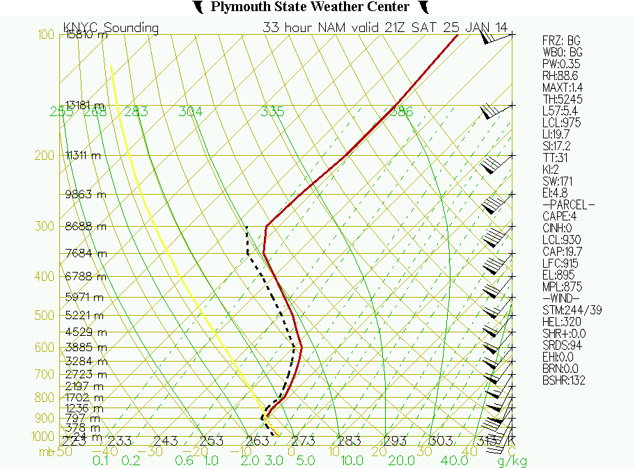
NAM forecast sounding valid for 4:00pm tomorrow for NYC shows strong southwest winds, and strong low-level instability, supportive of snow showers and snow squalls.
A quick look at a model sounding for NYC reiterates the points addressed above — strong southwesterly flow out ahead of the cold front, warm air advection and even some moisture advection at the surface beneath a colder pool aloft in the presence of the Polar Vortex, which helps to yield surface instability and additional lift, and temperatures staying below freezing throughout the entire column. This instability is what can help to generate heavier snow squalls.
Two other quick things to note:
1) As the cold front passes later on during the evening, there will be a secondary vorticity maximum swinging through the base of the trough — most likely in the DelMarVa. This leads to the threat of a second snow squall later during the evening and in the early overnight, particularly for southern NJ, since they will be just north of that vorticity maximum.
2) The threat for locally enhanced ocean-effect snows exist for Long Island, particularly for eastern Long Island. One key ingredient for ocean-effect snows is a large fetch — meaning the winds are blowing off the water for a long distance, which helps to advect moisture. The further east you go, the larger the fetch is, given a southwesterly wind. This large fetch, in combination with an unstable atmosphere where 850mb temperatures will be much colder than the surface temperatures could yield a band of ocean effect snow, particularly for Suffolk County. This could drop an additional inch of snow or so, so we would not be surprised if parts of Suffolk County also had 2″+ snowfall reports.
Leave a Reply
Want to join the discussion?Feel free to contribute!