-2")
Freezing rain, warmup prelude polar air intrusion
As crazy as it may currently sound, temperatures in the 40’s and 50’s are not far away. The teens and 20’s which settled into the area behind the significant snowstorm on Friday have essentially dominated the weekend, but an increasingly strong southerly flow will eventually push out the cold air in favor of warmer air surging northward. The cold air will be slow to scour out at the surface, however, which could create the potential for freezing rain across the interior. Below, a forecast sounding from Northeast NJ shows the very cold air trapped at the surface — but warm air aloft. This kills the development of snowflakes, so precipitation falls as rain, but the rain can refreeze at the surface once it falls as temperatures remain a few degrees below the freezing mark of 32 F. By later Sunday into Sunday night, forecast models are in good agreement that precipitation will have changed to all rain across the forecast area.
The warmup will come to a crescendo on Monday morning and early afternoon, just ahead of an approaching cold front. A large and powerful system forming over the Central United States (more on that below) will drive extremely cold air into the Central and Eastern United states by Tuesday. But along and ahead of the front, increasing low level moisture and rising temperatures will be the cause for showers and temperatures into the 40’s to near 50 early on Monday. Behind the front, the coldest air in recent memory will begin surging into the area.
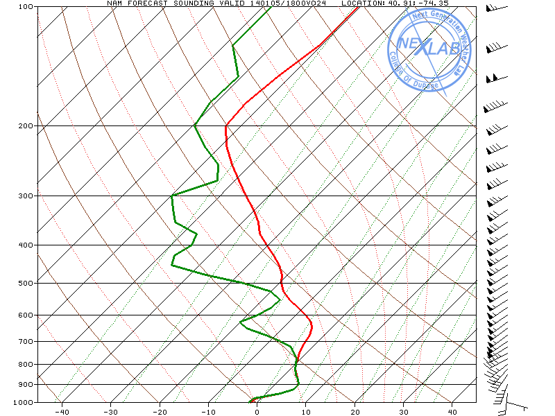
A forecast sounding from the NAM model in Northeast NJ on Sunday. Notice the cold air (below freezing) trapped near the surface while warm air dominates aloft.
Amazing displacement of Polar Vortex will lead to outbreak of arctic air
There has been a lot made of the Polar Vortex over the last few days, in the media and on social networks, since the upcoming arctic outbreak seems to be coming to fruition. And to be frank, the Polar Vortex isn’t used to this much attention! In all seriousness, the vortex hangs around just to our north during the winter months more typically than one would think — it actually has a major part in many of our winter storms whether or not it is directly involved. But this time around, it’s dipping farther south with more vigor — and it is drawing a lot of attention to itself.
The vortex is best defined as a persistent, large cyclone which features cold dense air and typically hovers near the earths poles. It exists all year round — but is obviously much weaker in the summer. During the winter it tends to be shuffled around by the changing mid latitude wavelengths and increase in high latitude blocking ridges. This time, it’s shifting into the Central United States and sliding east/northeast as it phases with a Pacific disturbance. This will produce a snow event over the North-Central United States and parts of the Great Lakes, and bring the aforementioned strong cold front into our area. But behind the front will come the intrusion of polar air.
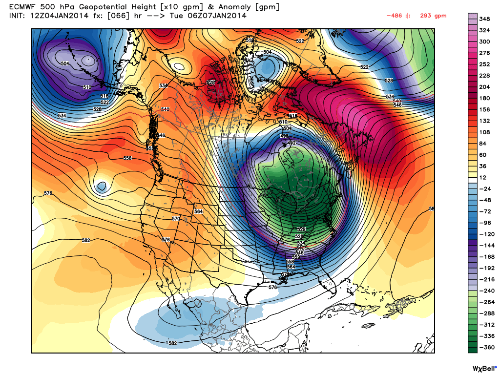
ECMWF model showing the polar vortex and associated height anomalies at 500mb across the Central/Eastern US this week.
As far as record low temperatures, go this polar vortex track and strength fits fairly well into the textbook for near zero temperatures in New York City. But the timing, on all forecast models, is poor. Guidance moves the cold front through the area on Monday, with the core of the vortex and associated cold temperatures (near -28 c at 850mb!) through during Tuesday afternoon. So while overnight temperatures amy not set records on Monday, they will still be cold — and the daytime highs on Tuesday will be simply bone chilling.
West winds will pick up with impressive strength behind the front on Monday and continue through the day on Tuesday. As 850mb temperatures drop below -25 C, high temperatures on Tuesday are not forecast to move out of the single digits on many forecast models. While it may be a bit warmer in the city due to urban heating, Tuesday will certainly be one of the coldest days in recent memory — it has simply been a while since we have seen temperatures this cold aloft.
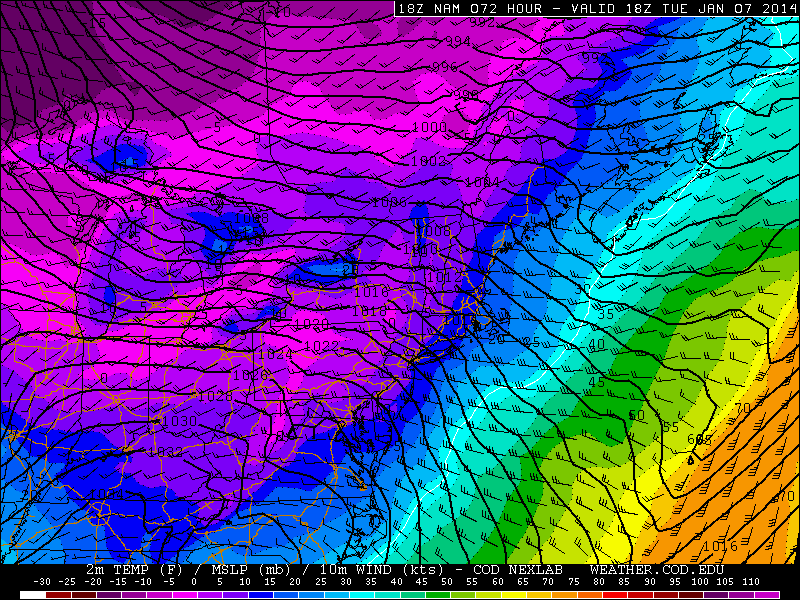
NAM model forecast temperatures during the mid afternoon on Tuesday — in the single digits.
Some daytime high temperature records throughout the area may be jeopardy if the forecast models are correct — but for now, we’ll have to wait and see. The aforementioned west winds will also create dangerously cold wind chills which will likely stay below zero even during the daytime hours on Tuesday. It’s important to remember that cold is dangerous; please wear layers and avoid spending too much time outside.
The dangerous cold looks to move out of the area by later in the week as the airmass modifies a bit and the polar vortex returns from whence it came.
Leave a Reply
Want to join the discussion?Feel free to contribute!