-2")
Polar air brings first record low to NYC since 1996
New York City had not broken a record “low” temperature since March 9, 1996. That’s almost eighteen years ago, which is hard to fathom especially when considering the amount of high temperature records which have fallen in the time since then. Yet the daily record low temperature for January 7, which was previously 5 degrees, fell on Tuesday when Central Park’s temperature dropped to 4 degrees — breaking the near eighteen year streak. The previous low of 5 degrees was set 118 years ago, during very early observations at Central Park.
More impressive, without a doubt, were the widespread single digit temperatures and strong winds which combined to yield wind chill values from -10 to -25. The arctic front which passed through the area early on Monday brought gusty west winds and 850mb temperatures of -25 to -30 C, by far the coldest air of the season to date. The airmass wasn’t unprecedented, however, as these type of polar intrusions have certainly occurred before. The piece of the polar vortex which surged through our area tucked to the south of a powerhouse low pressure system bombing out over Eastern Canada, which helped strengthen the pressure gradient and surface winds.
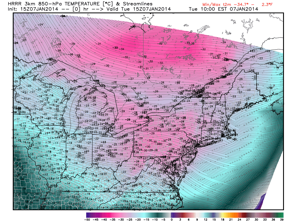
850mb temperatures dropped to near -30 C throughout the area on Tuesday morning as a piece of the polar vortex shifted overhead.
The airmass will modify rather quickly during the upcoming week despite the continued presence of cold air aloft and very low mid level heights. This is fairly typical, as the polar air loses its source and begins to modify to the warmer airmass around it (near our latitude and longitude). Still, highs in the mid 20’s with gusty west winds will continue to feel quite cold on Wednesday. By later this week, rising mid level heights will usher in even warmer air and we can actually start beginning about the potential for a January thaw. Regardless of how brief and transient it may be, the warmth will be welcomed with open arms after the record breaking cold of early this week.
X-class solar flare could be earth directed
An x-class solar flare erupted on an active location of the sun on Tuesday, officially categorized as an x1.2 flare. The solar flare was observed on several high resolution images of the sun, with significant dimming after its eruption adding credence to the idea that this eruption was stronger than some previous. The solar flare seems pointed in a general earth-bound direction, although it remains to be seen exactly how much of the impacts will reach us.
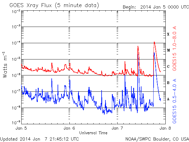
Data showing the X-Class solar flare on Tuesday afternoon.
Early models from NASA and the Space Weather Prediction Center suggest a strong chance of impacts on earth by late on January 8th into January 9th. Additionally, early indications point to Kp index values between 6 and 8 — very near the threshold necessary for northern parts of our area to observe aurora. We will have to wait for answers in regards to the exact impacts and severity of the solar flare.
Leave a Reply
Want to join the discussion?Feel free to contribute!