-2")
Moderate snowstorm likely on Monday
A low pressure system developing along a stalled frontal boundary is likely to bring precipitation to the entire area beginning early Monday morning, with cold air funneling in from the west/northwest behind the front and changing precipitation to snow throughout the area. Forecast models have trended much farther north and more expansive with the precipitation shield associated with this low pressure — and as a result, we are now expecting the potential for moderate snowfall accumulations throughout the area. There are several uncertainties still remaining with the forecast system, including timing and temperatures, but confidence continues to increase in the accumulation forecast today.
Snow is expected to begin in Northern NJ, NYC, SE NY and Connecticut during the early morning hours on Monday. Across parts of Central and Southern NJ, precipitation may begin as rain or may be mixed. As precipitation intensity increases, dynamic cooling will occur — changing most areas to snow. The exception may be in Southeast NJ and parts of Long Island, near the coast, where warmer air in the low levels will keep precipitation mixed or stop snow from accumulating. Elsewhere, moderate to heavy snow is then expected to continue throughout much of the morning and early afternoon.

Storm Total Snowfall Forecast as issued by our meteorologists on February 2, 2014.
The heaviest will likely come from late morning to early afternoon, depending on location, when lift is maximized as the storm passes by to our south. Precipitation is expected to become lighter and end by the evening hours. Total snowfall accumulations remain somewhat uncertain and will vary greatly depending on location and ground temperature. Currently, our highest confidence in amounts greater than 4″ exists from Central NJ to Northeast NJ and areas near New York City. Places closer to the coast may see slightly lower amounts. The potential additionally exists for some higher amounts in heavy snow bands.
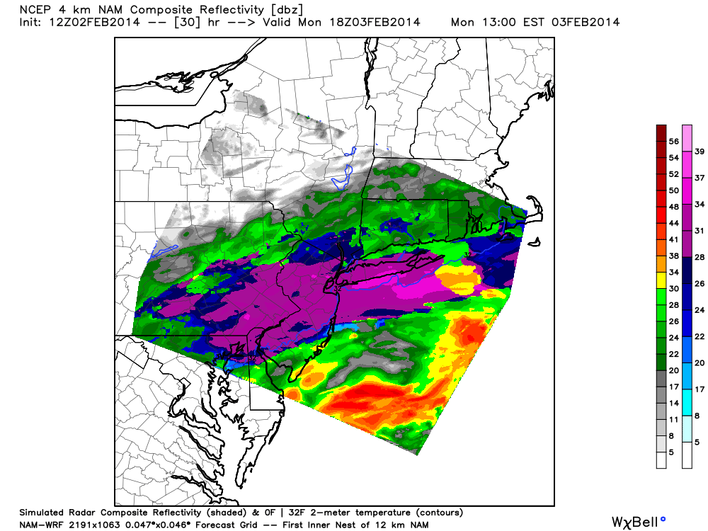
NAM model showing heavy snow from NJ to NYC on Monday.
The surface temperatures are one of our main issues in forecasting higher snowfall amounts — as the entire atmospheric column will be somewhat borderline for snow and flake production. We’re expecting fairly low snow to liquid ratios and a very wet, paste-like snow. So despite 0.75″ of liquid expected in some areas, the general idea of 3-6″ of snow remains the same. Additionally, accumulations initially lost to warm ground are factored into our forecast with lower snow totals near the coasts.
We advise that you plan for extra travel time and expect delays on Monday. This will be especially true for those flying in and out of NYC and surrounding areas. The morning and afternoon commutes look to be messy with significant delays as well. Stay tuned for further updates. For our premium members, we will be activating our Live Blog on Monday at 2:00am.
For more details, our latest forecast discussion can be found here: http://www.nymetroweather.com/discussion/
Leave a Reply
Want to join the discussion?Feel free to contribute!