-2")
Attention shifts to the weekend and next week for more snow chances
Our snow and ice storm is moving out of the region, producing copious amounts of snow just north of the city — where up to a foot fell in Southern New York and parts of New England. 4″ of snow fell in New York City, before turning over to 1/4″ of freezing rain, and a widespread significant ice storm resulted in widespread power losses in interior New Jersey and Pennsylvania. Quite frankly, it is a mess outside. Concerns begin to elevate again, as temperatures begin to fall back into the 20s, leading any standing water on roadways to refreeze back into ice. Additionally, tree limbs may also collapse on area roadways, leading to more problems. We highly recommend taking serious caution when commuting this evening and tonight. Tomorrow morning’s commute may even be hazardous, as well.
Now that this storm is wrapping up, we can begin to shift our attention towards the weekend. A couple of days ago, many computer models began to show a potent nor’easter hitting the East Coast producing widespread significant snowfall amounts. And while many of the ingredients are still there for a major snowfall, the evolution of the pattern has changed a bit as none of the models are forecasting a major snowstorm for the weekend at this time. That being said, we still need to keep a close eye on this system. For more background information on the evolution of the pattern, why it is so active, and what the models were initially showing this weekend, check out our article from two days ago.
Let’s take a look at what has changed. Below, we will see the 500mb pattern on the European Model from two days ago, valid for Thursday evening, as well as today’s European model, valid for that same time period.
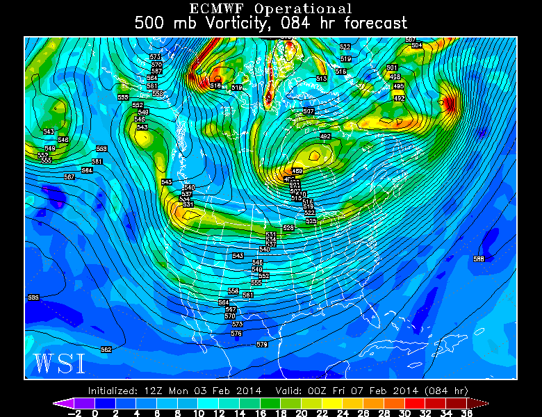
The European Model run at 500mb from two days ago, valid for Thursday evening. It showed more potential for a big storm this weekend. Image credit goes to the WSI Model Lab.
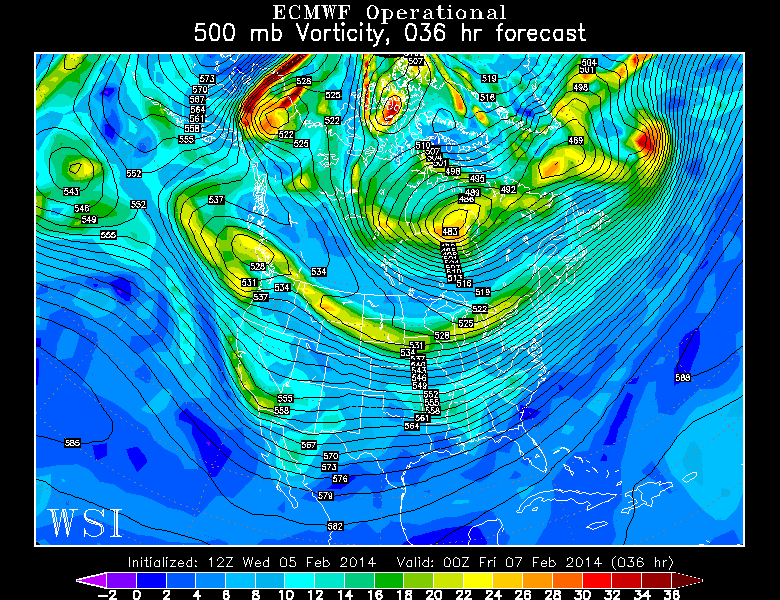
Today’s European Model valid for Thursday evening shows a less amplified pattern in Western Canada, which explains why it is not as threatening for this weekend. Image Credit goes to the WSI Model Lab.
The changes may appear to be a bit subtle at first, but they become more noticeable when we look at Western Canada. Notice how the top image shows the height lines oriented much more due north to south, which allows any energy to dive southward and consolidate. However, in today’s image, the height lines are oriented northwest to southeast, which allows more energy to scoot eastward, instead of diving down to the south. This leads to a much more elongated piece of energy, a more progressive west-to-east pattern, and one where the main batch of energy avoids “phasing” with the energy that is diving to the south. What we mean by that last statement can be seen in Southern California — notice how in today’s image, some energy is separating, and is allowed to run due eastward, and misses interacting with the powerful system in the Pacific Northwest. This leads to a weaker system.
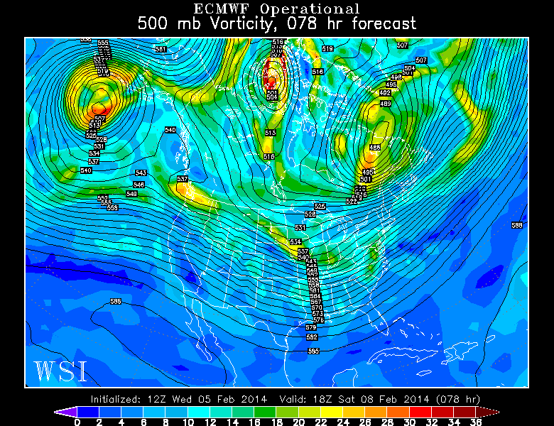
The European Model run from two days ago shows the piece of energy in California phasing with the powerful energy in the Pacific Northwest, which led to a powerful storm system. Image credit goes to the WSI Model Lab.
Today’s European Model shows that piece of energy in the south being able to outrun the energy to the north, thus resulting in a weaker solution. Image credit goes to the WSI Model Lab.
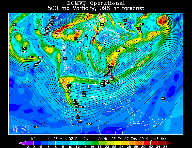
Fast-forward to Friday morning, and the changes are apparent now. Notice how on the top image, since the energy in the Pacific Northwest was stronger and more consolidated, and the heights in Western Canada were oriented due north to south, that energy was able to dive due southward and phase with the energy in Southern California. This creates quite the powerful storm system.
However, with the image on the bottom, notice how the energy in Southern California completely outruns the energy in the Pacific Northwest. The core of the energy in the Pacific Northwest was not able to dive to the south, and it instead gets split and elongated. The energy in the south will thus run to the east, but have nothing to capture it and help it turn to the north.
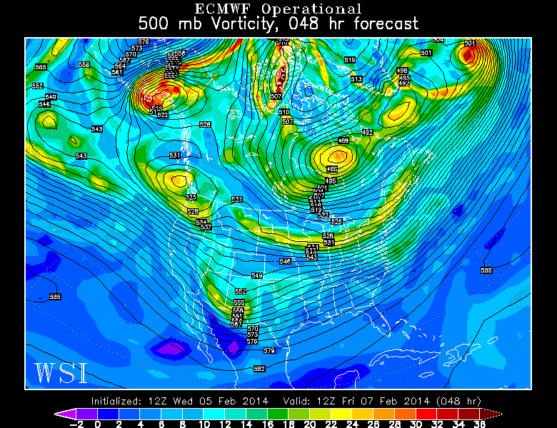
Today’s European Model valid for Saturday afternoon shows that lead energy in the South head towards the Northeast, but get weakened and sheared out since it was never able to interact with the Northern Stream. Image credit goes to the WSI Model Lab.
Moving forward to Saturday afternoon, we can see that the southern stream energy treks northeastward, and is now in the coastal Mid-Atlantic. However, since it never was able to interact with the northern stream energy a couple of days prior, and the fact that it runs into a big area of confluence to the north leads it to dampen out, and it does not provide much in the way of snow at all.
What ends up happening this run is that the leftover elongated shortwave in the Midwest amplifies a bit on its own, and turns into a light snow event for Sunday.
Can the snowier solutions come back? Yes, they still can. Although the general look of the pattern has changed a bit, there are still several favorable pieces for a snowstorm. The two things that still stand out to us are the strong -EPO ridge, and the increased blocking southwest of Greenland. The increased blocking southwest of Greenland will help to slow down and amplify the pattern in the Midwest, which may be able to lead to a stronger and further south piece of energy in that location.
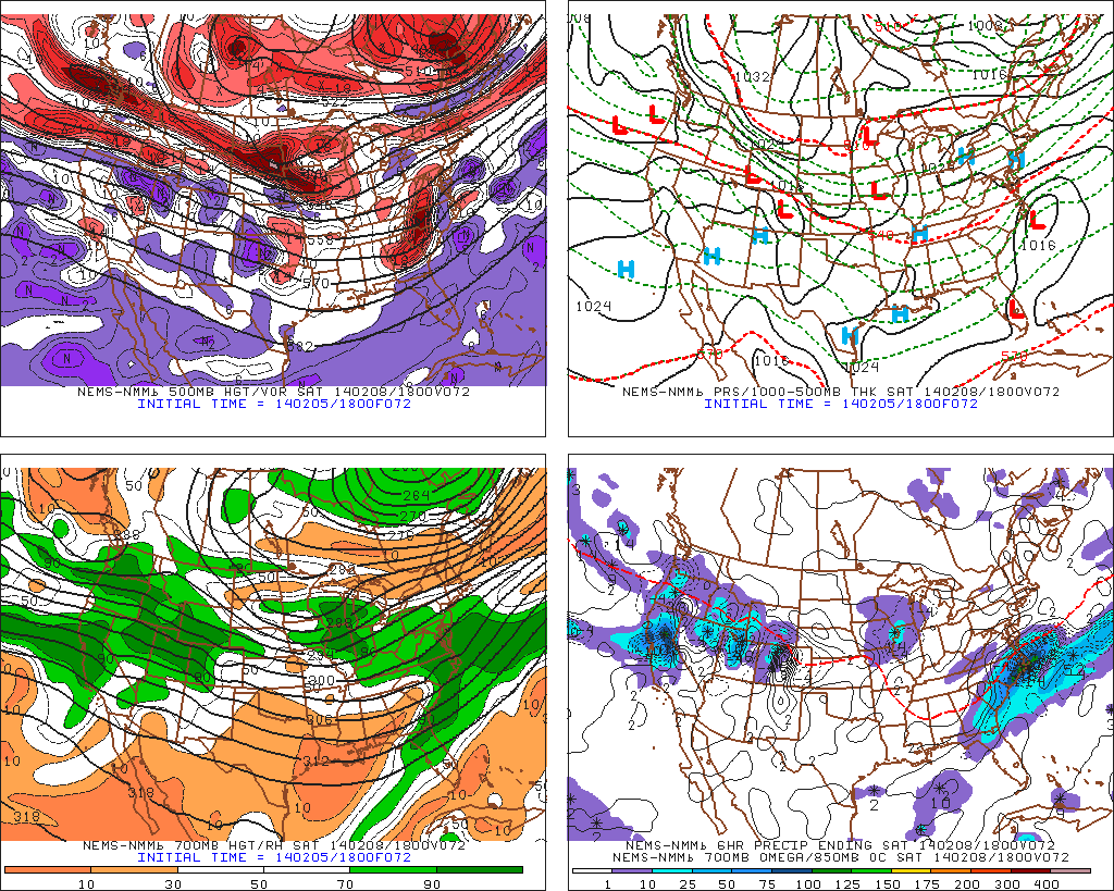
Today’s 18z NAM valid for Saturday afternoon is close to showing one scenario where a significant snowstorm could still result for the weekend. (PSU-E-Wall).
If in combination with that area of vorticity in the southern stream becoming stronger as well, it could easily get tucked into the coast by that oncoming shortwave in the Midwest. This could result in either a significant partial phase/full phase between the two pieces and a major snowstorm for Saturday night, or simply additional interaction between the two systems, and an inverted trough feature, leading to some moisture getting pulled back from the offshore storm, and a light to moderate snowstorm on Saturday night.
The other way a major snowstorm becomes possible again is if the area of vorticity in the southern stream trends weaker. This would allow for greater emphasis on the piece of energy being enhanced by the blocking in the Midwest, instead of them interfering with each other. The blocking would allow for that piece of energy to strengthen and amplify all on its own, and produce either a Miller B type snowstorm, or snow from an inverted trough, on Sunday.
Considering the trends this season for storm systems to trend more amplified and stronger on the modeling in the short term, it would not surprise us at all if one of the two above scenarios came true. That being said, as of now, the models — verbatim — are favoring a light snow event on Sunday. We believe at the very least, a light snow event this weekend is likely, and the chance for a significant snowstorm is still there.
And believe it or not, the active pattern does not stop. Because of the huge Pacific Northwest disturbance not ejecting all at once, it will instead come out in pieces every few days. This leads to the potential for two more pieces of energy next week to become snowstorms — perhaps one next Wednesday, and another next Friday. Although the huge -EPO block will be reloading a bit, the continued trends for more blocking southwest of Greenland, combined with energy coming out in pieces from the Pacific will lead to an active pattern with a few snow chances going down the road.
Leave a Reply
Want to join the discussion?Feel free to contribute!