-2")
Light to moderate snowfall likely Tuesday
After going a whole 12 to 24 hours without the area seeing snow, snow will finally be making its return to the region for late tonight and through tomorrow morning, ending the prolonged snow drought.
Kidding aside, there will be a potent mid-level wave traversing the Midwest and Great Lakes throughout this evening, leading to moisture developing out ahead of it into our relatively chilly airmass. Not surprisingly, there is a battle between the higher resolution mesoscale models (NAM, ARW, RGEM, RPM) showing more precipitation, and the global models (GFS, and Euro) showing less precipitation. Nonetheless, however, today’s data has indicated a slight upward tick in precipitation across the region, which may allow some of us to receive a bit more snow than initially thought.
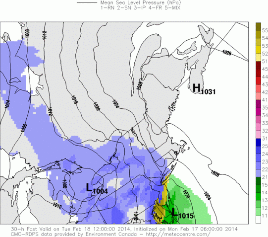
Today’s 12z RGEM (short-term Canadian model) shows a storm system running into a departing surface high pressure system, leading to snow for many areas, with mixing along the immediate coast.
Today’s 12z RGEM model shows a 1004mb low near the Great Lakes moving from west-to-east into a departing 1031mb surface high. This high pressure system will initially be anchored over Northern New England, which will help to keep temperatures initially cold everywhere. This will allow snow to break out over the entire region. However, as the surface high pressure system moves eastward, and the low pressure continues its close approach, winds will begin to shift to the southeast, and warm temperatures in some spots. Identifying the degree of this warming and how far north it penetrates will be very crucial, as areas who remain all snow could certainly see a quick-hitting 3-6″ of snow, whereas areas who mix may only see 1-3″ before turning over to rain and/or drizzle.
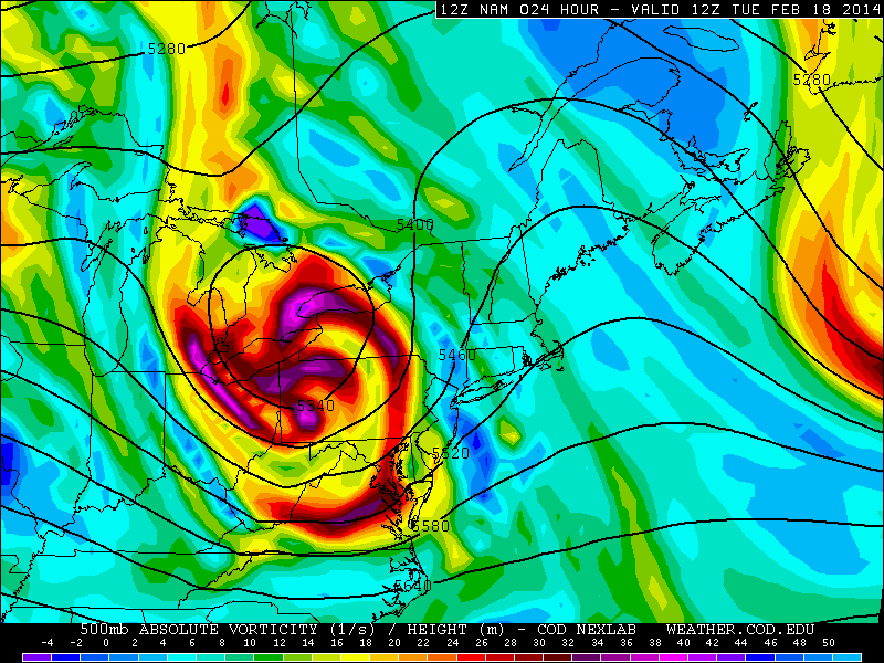
Today’s 12z NAM valid for 7:00am tomorrow shows a potent closed 500mb low in the Great Lakes, supporting our storm system.
The 12z NAM does show a potent mid-level disturbance, which should tend to mean more precipitation than not. This should support decent lifting out ahead of the storm, enough to support a burst of moderate to heavy snow. That being said, in the above RGEM image, one can note a secondary area of developing low pressure. Where and when exactly this secondary low pressure develops is also quite important, as sometimes a secondary low pressure can initially steal some moisture from the primary low, particularly a bit northwest of the secondary low. This is one reason why we feel that the NAM is too wet, but the potent storm system should allow for higher precipitation amounts than the GFS shows.
As noted earlier with regards to warming surface temperatures, the depth of boundary later warmth as well as precipitation rates will be critical in determining the snowfall for coastal sections. There are a few factors at play, including the fact that an initial deep snowcover will try and keep surface temperatures colder than models are forecasting, which makes me skeptical that this will be a mostly rain event for most of Long Island. However, a closed off 500mb low to the west and northwest of the region tends to mean a strong fetch of southeasterly winds, which supports potential boundary-layer warmth from the surface up through around 1,000 feet. That being said, the ocean is quite cold, which may mean the boundary-layer warmth is weak, and could be overridden by heavier precipitation rates.
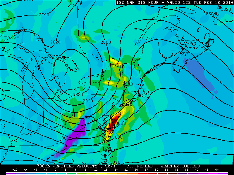
Today’s 18z NAM shows the best 700mb upward vertical motion staying in South Jersey, and eventually going to Long Island — thanks to the development of a secondary low pressure system.
We will be issuing a snowfall map later detailing our thoughts graphically. But as of now, we favor 2-4″ for NW NJ where temperatures will be colder, but precipitation will not be maximized thanks to the secondary low robbing their moisture somewhat. Although temperatures will be slightly warmer further south and east, stronger lift could mean the same snowfall amounts from W Central NJ, through Middlesex and Union Counties, with perhaps a 3-6″ bullseye somewhere in NE NJ. NYC itself looks to receive 2-4″; closer to 2″ in southern sections, and 4″ for parts of the Bronx, before changing over to light rain. Long Island is a big wildcard — they will receive the most precipitation, and if that can override the warm boundary layer, 3-6″ could fall — but given the unfavorable track of the storm, it is hard to believe that surface temperatures will not rise into the mid 30s, leading to accumulations generally between 1 and 4″; 4″ for areas on the North Shore, before changing to some rain. Timing looks to be between 4:00am and 6:00am for the start — creating a messy morning commute –and ending between 10:00am and noon.
Later tonight, we will also be writing an article about the potential warmup for later in the week, with temperatures potentially surging through the 50s on Friday, with the potential for thunderstorms as well. However, the warm-up will be short-lived, as next week will see a return to a significantly wintry weather pattern.
Leave a Reply
Want to join the discussion?Feel free to contribute!