-2")
Explaining the uncertainties with the upcoming snowstorm
Although yesterday saw pretty good agreement among most computer model guidance regarding a major snowstorm on Monday, we were still four days away from the storm, which is a pretty long time in the realm of computer modeling. In more plain terms, this means that despite this agreement, we were still susceptible to changes in modeling that would ultimately affect the outcome.
The current weather pattern is dealing with a strong storm system crashing into southwest California, as well as a strong Polar Vortex in Southern Canada, supplying cold air into much of the country. This storm system in southwest California is forecast to move eastward, and as it does, will be increasing the warmth and moisture out ahead of it as it interacts with the Gulf of Mexico. Additionally, the Polar Vortex is forecast to exert its muscles and intensity the cold around it and just to its south. This leads to a strong source of anomalously cold air in the north, and anomalously warm air to the south — creating a strong temperature gradient which should lead to widespread, heavy precipitation just north of this gradient. This part seems easy.
But it’s much more complicated than that. The Polar Vortex in a way is a double-edged sword. While it can supply the cold air to strengthen the gradient, it can also be so strong that it shears out the initial storm system. If the initial storm system gets sheared out, then its ability to generate warm air advection out ahead of it and spread northward is decreased, which means the thermal gradient weakens and gets pushed to the south.
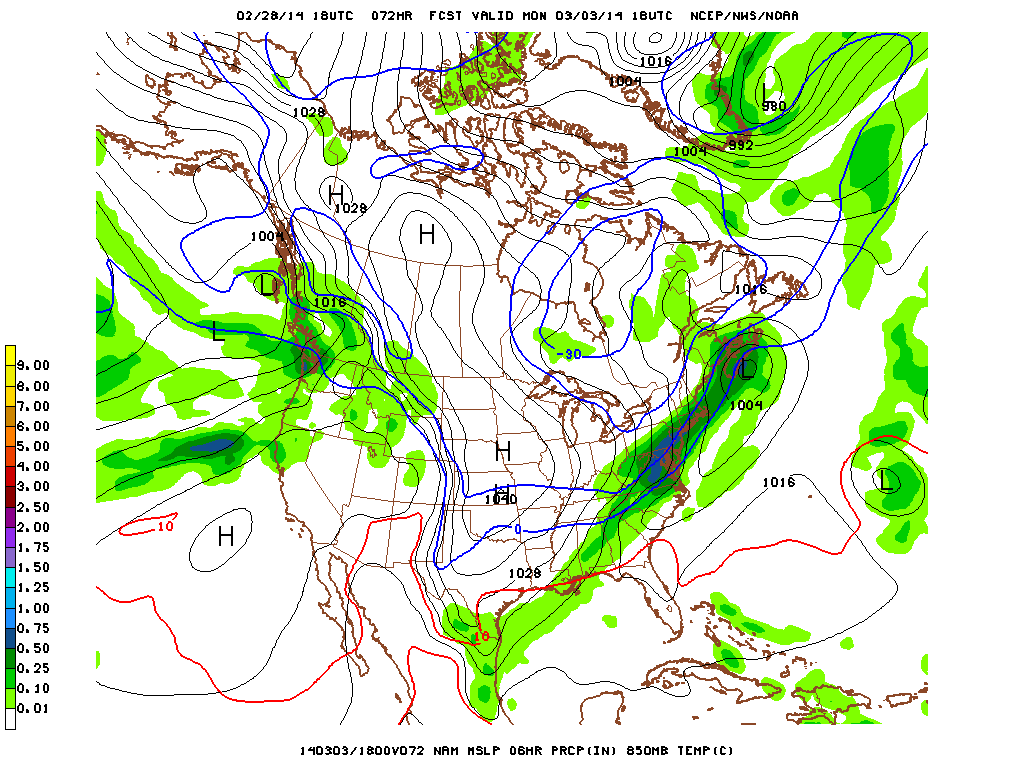
Let’s take a look at some computer models. Today’s 18z NAM showed a major snowstorm of 10-15″, whereas today’s 18z GFS only shows a few inches. Below, we will see the 18z NAM valid for 10:00pm, Saturday night.
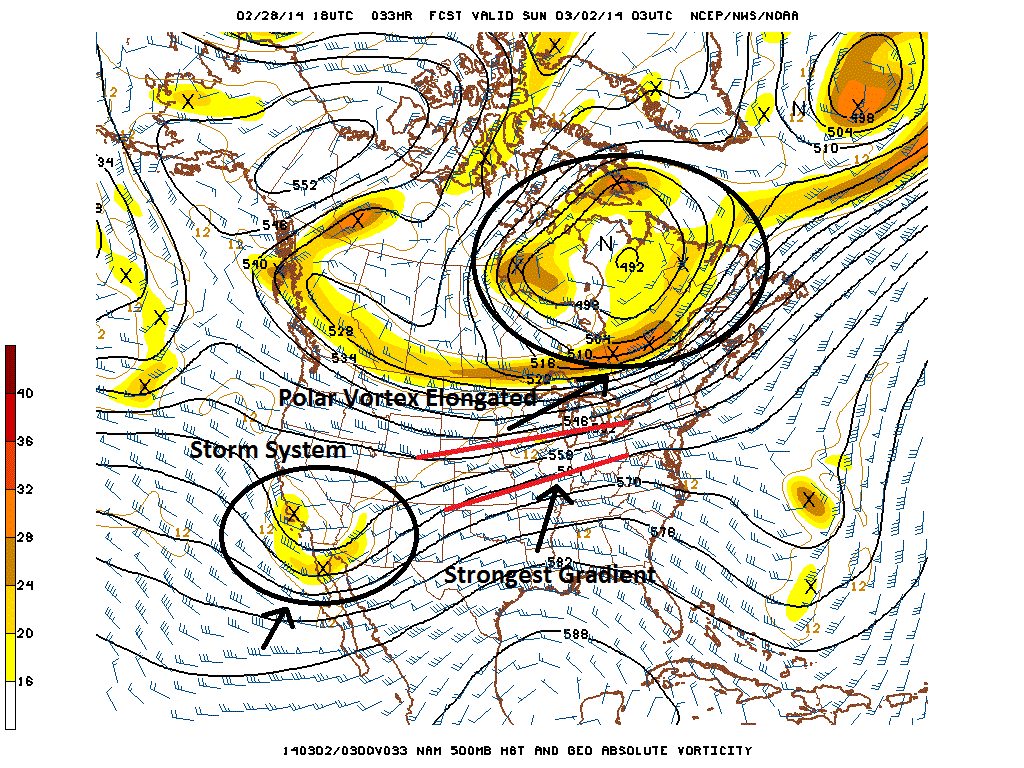
Today’s 18z NAM at 500mb valid for 10:00pm Saturday night shows a favorable setup for major snow, due to the Polar Vortex becoming elongated, as opposed to compressed.
The above image is taken at 500mb — roughly the middle of the atmosphere. We can see our strong storm system in the Southwest. In Canada, we see a large piece of the Polar Vortex, which has become somewhat elongated. Notice the strong piece of energy stretched out on the west side of the Vortex, which reinforces its elongation. Additionally, this allows for some height rises in SE Canada just beneath the Vortex, despite the relatively compressed flow. The strongest height gradient is outlined in red, which is streaming right towards our area.
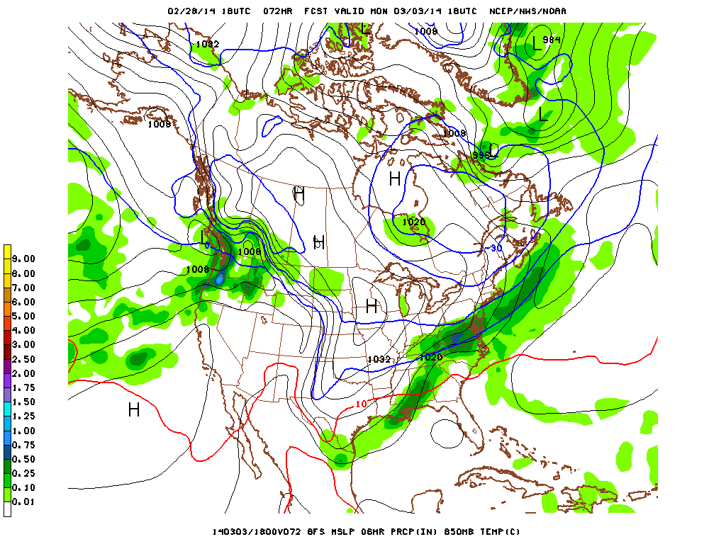
Now, let’s take a look at today’s 18z GFS, also valid for 10:00pm Saturday night.
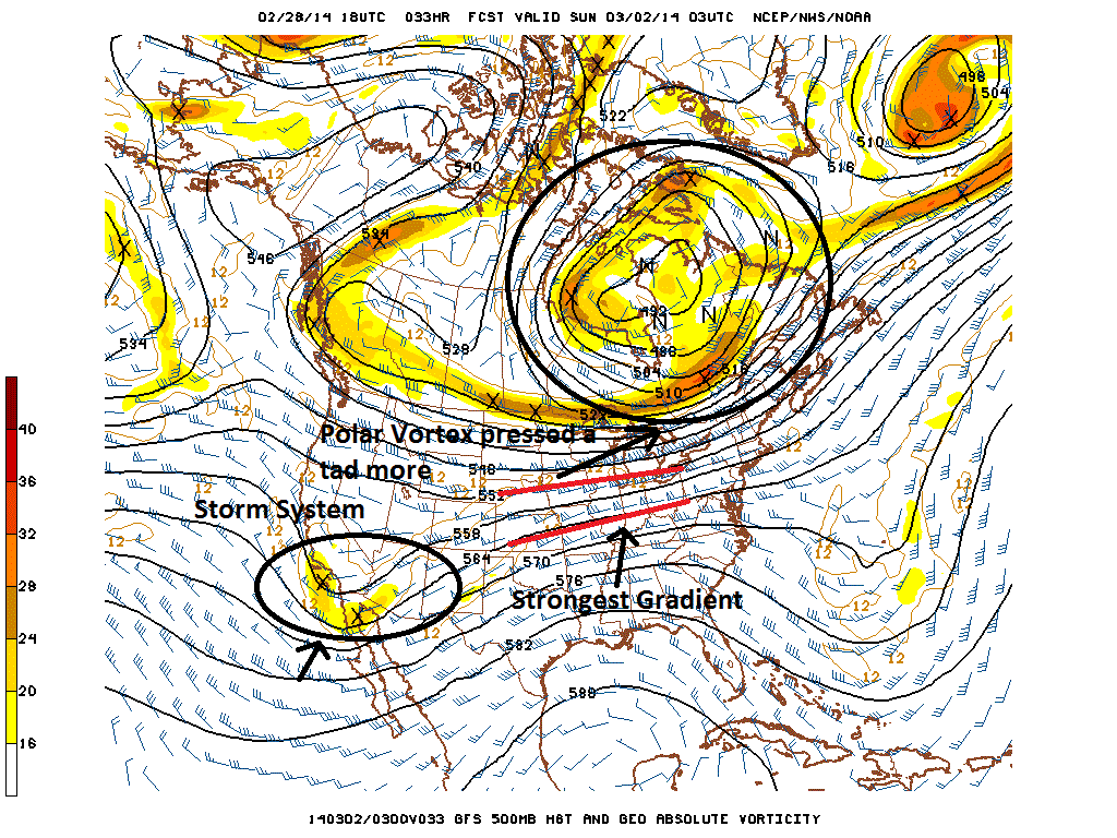
Today’s 18z GFS at 500mb valid for 10:00pm Saturday shows a slightly less favorable pattern for snow than the NAM, due to the Polar Vortex being pressed a bit more, which suppresses the flow.
Looking at the storm out west, we do not see any major differences, which seem to indicate that the storm’s initial strength may not be as important as one would think for the final outcome of the storm. What is more important is the orientation of the Polar Vortex. Although it appears subtle, if we look closely, we can see that the Vortex is slightly less elongated, and has a greater north-to-south orientation as opposed to an east-to-west orientation. This allows the heights in SE Canada to be a tad lower, which leads to suppression. Additionally, notice how the energy rotating on the back side of the Polar Vortex is further east on the GFS than it is on the NAM. This will not reinforce elongation, and leads to lower heights further east — where the storm is supposed to track — which also helps to suppress the storm system. The initial gradient, however, is in generally the same location, which proves how subtle the changes really are and the fine details involved regarding the differences between a few inches of snow, and over a foot.
Let’s move forward a bit on today’s snowier NAM model to 10:00pm on Sunday night. The differences become a bit more pronounced.
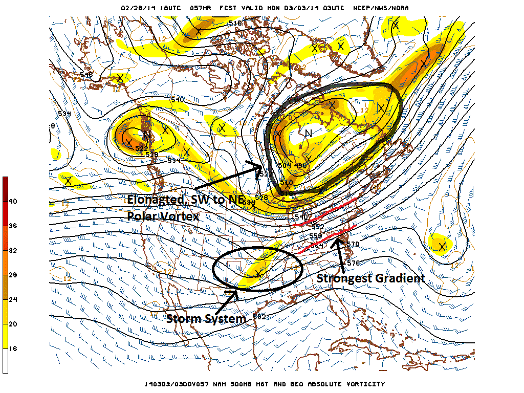
Today’s 18z NAM at 500mb shows a favorable setup for major snowfall, as the strongest thermal gradient is oriented in a SW to NE fashion, which allows heavy precipitation to creep towards out area.
We can see that the storm system is still relatively strong in the Southern Plains, and the heights ahead of it have risen. This leads to warm air streaming northward. The Polar Vortex to the north has become quite elongated, in a southwest to northeast fashion. This allows for heights to increase a bit in that same fashion in the northeast as well. This means that the gradient can also align in that same exact fashion, which keeps precipitation pumping northward. Furthermore, note how that initial energy that was rotating on the back side of the Polar Vortex has still hung back pretty far west, and is attempting to interact with our storm system. This decreases heights within the longitude of the storm system itself, creating a “troughy” look, which also reinforces height increases out ahead of the storm, further helping precipitation to go northward.
Today’s GFS valid for 10:00pm on Sunday night is quite different, however.
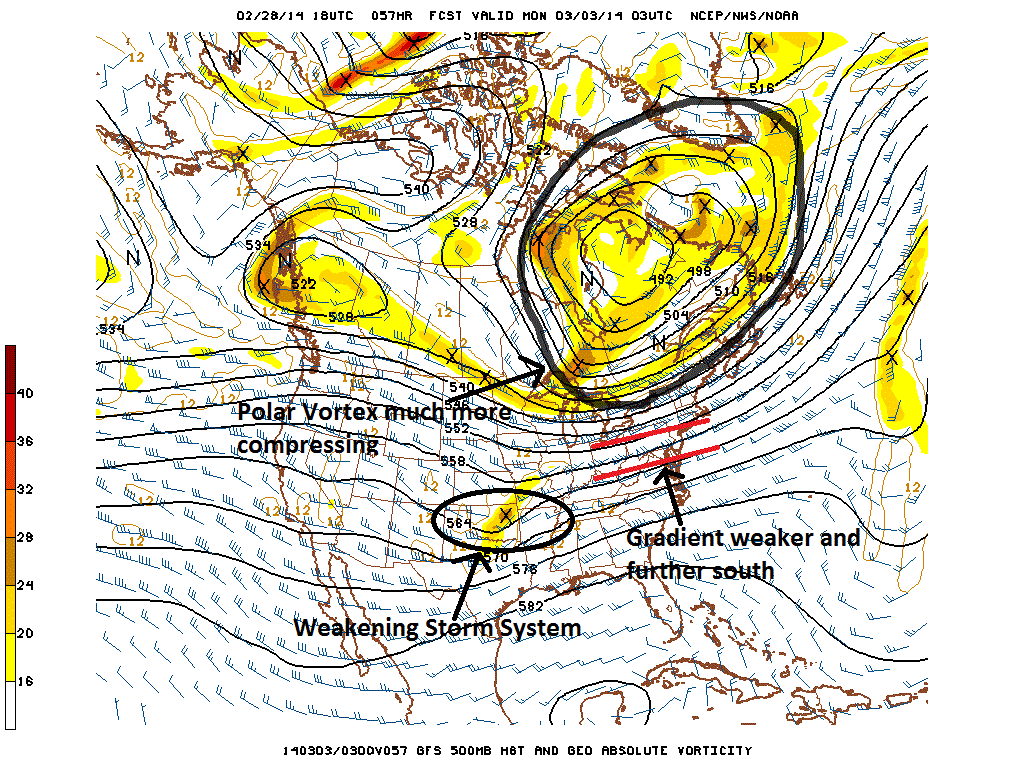
Today’s 18z GFS shows the Polar Vortex compressing the pattern, weakening our storm, and keeping the heaviest precipitation to our south.
The storm system has become much weaker on this run, for a couple of reasons. The Polar Vortex is not nearly as elongated — in fact, it has become even more compressed, and it is suppressing the heights greatly in the East. Thus, our storm system is running into a hostile environment. Additionally, that piece of energy which was rotating around the back side of the Polar Vortex is much further east. This means that it is not interacting with our storm system, and instead races ahead of it. This means that the dip in the heights along the longitude of our storm is not nearly as pronounced, creating a flatter look, and the height rises ahead of our storm actually become a small area of height falls. Our storm system is forced to travel in an area where heights are flattening, which leads it to weaken. A weaker storm system will not be able to generate as much warm air advection out ahead of it, which means warm air cannot go as far northward. This means that the temperature gradient weakens, and becomes oriented to the south.
Today’s 18z NAM shows heavy snow with precipitation oriented from southwest to northeast.
From a more broad perspective, the Polar Vortex in general is a hair east on the GFS compared to the NAM as well. This means that in general, heights get suppressed more the further east you go — which in this case, is ahead of the storm. Thus, after 10:00pm on Sunday night, the strongest gradient gets pushed even more to the south, and the heavy precipitation ultimately misses our area.
Which model will be right? Modeling the exact orientation of the Polar Vortex is quite tricky, especially if the biggest differences really are as subtle as the exact location of a piece of energy on the back side of it — since this affects how elongated the Vortex becomes, as well as how much energy can interact with our system. It goes to show how delicate of a science meteorology is, and why forecasting these snowstorms can become such a nightmare.
Today’s 18z GFS shows lighter precipitation missing to our south, and it is oriented from west to east.
We are currently leaning towards a blend of the interaction with the Polar Vortex. The pattern in our opinion is anomalous and has enough blocking to prevent the Vortex and associated energy from moving east and compressing our heights. There is enough blocking to force some elongation, as well, which would argue that today’s GFS trends to the south are definitely an over-correction. Additionally, the storm should probably be a bit stronger than the GFS has it, due to strong tropical forcing and an active sub-tropical jet-stream. We do know the shortwave will weaken — but if the gradient initially becomes strong enough and oriented enough to the north, we can still get significant snow. That being said, the blocking in the North Atlantic in itself is not that anomalous, which means that the Vortex can only get pushed back and elongated to the southwest so much, before eventually sliding eastward. Thus, although a 6″+ snowstorm (or even 10″+) for our region is certainly possible, there are definitely enough variables which could keep this storm mainly to our south to prevent us from having more than 50% confidence in that.
What should we look for in future runs for a more significant storm?
1) An elongated Polar Vortex with more energy diving in on the west side of the vortex. This leads to more troughing in the longitude of our storm system.
2) Somewhat related to point #1, but a meridional flow (north to south) just west of the vortex, which is an indicator of a slower, more amplified pattern, where the Polar Vortex will not move east and suppress our heights as quickly.
3) A stronger shortwave in the West and Plains.
We will be sure to keep everyone updated on tonight’s and tomorrow’s computer model runs. Until then, enjoy your Friday night and the weekend!
Trackbacks & Pingbacks
handbags by louis vuitton
Creative creativity Nicolas Nicolas Nicolas Gsquière often chooses his architectural scenes as a display. He has performed in the most breathtaking locations in the world, including the Global Aviation Flight Center in New York Airport and the Miho Mus…
louis vuitton outlet flagstaff arizona
The Original Women louis Vuitton Sale|Authentic Women louis Vuitton Sale|Cheap Louis Vuitton Handbags Factory Outlet Online Sales signature in the handbag uses hot stamping film, the location of the Original Women louis Vuitton Sale|Authentic Women lou…
franchise louis vuitton
In 2014, he returned to Milan, Italy to develop. At the time, designers in Milan saw his eyes full of eyes, because Misza Patinski had eyebrows like British supermodel David Gandy (David Gandy). Gandhi).
louis vuitton outlet online
The soft Twist directly knocked over the premium disc, full of colorful personality.
authentic louis vuitton handbags outlet
We only need to go back to the Golden Age or the Age of Enlightenment, when the essence of civilization was forged.
deauville louis vuitton
Thus, there was the Original Women louis Vuitton Sale|Authentic Women louis Vuitton Sale|Cheap Louis Vuitton Handbags Factory Outlet Online Sales 2021 spring and summer menswear collection, and the rapper 21 Savage was hired as a pioneer to interpret v…
outlet mall louis vuitton
C.G INC supply 100% authentic Louis Vuitton outlet here offers cheap Louis Vuitton,authentic Louis Vuitton,Louis Vuitton handbags,Louis Vuitton bags,Louis Vuitton purses online with free shipping.Welcome to Louis Vuitton official website and enjoy shop…
louis vuitton vernis alma
Frankly speaking, the 23 sets of clothes on the red pedestrian bridge are mediocre. They all rely on sharp colors and exaggerated graffiti, but the second part is quite amazing!
louis vuitton handbags usa
Because 2012 was a small climax in the male model industry, the youngest in the era of the last goddess that year, the fashion industry set off a trend of super male models, male models appeared in the youth model of the year, the golden age of the mal…
louis vuitton montres
In response to the theme of the Renaissance, flat boots similar to ancient Roman gladiators appeared on the show. The leather of the shoe body is matched with the retro Roman-style winding strap, which is chic and practical to wear.
cheapest item from louis vuitton
Shechisila
cheap official jordans
Today we ushered in the official illustrations of the white-red color Red Metallic and the white-orange color Orange Metallic, allowing us to have a more detailed overview of the unique charm of this “small white shoe” Cheap jordanss 4.
black jordan bookbag
$ 109.06LeBron XIII (13) Jujube black
nike sneakers for men
This year, the gray Cheap jordanss 1 has become a hot mainstream. The most representative nature is Dior x Cheap jordanss 1 and Cheap jordanss 1 Zoom, which is known as the small Dior.
cheap Authentic jordans online
$ 103.18Cheap Jordan1 “Fearless”-1
louis vuitton lv bags
Louis Vuitton Speedy Bag Current Prices Previous Prices
real air jordan retro for sale
With its streamlined cheetah shape and classic leopard eye shape, it is deeply imprinted in the hearts of shoe fans.
kids air jordan 11
At the same time, the light blue crystal outsole also keeps the upper feet from being too dull in autumn and winter, and injects vitality into the overall wear.。Online Shop Cheap Jordans,Jordan 1,4,6,11,12,13 Shoes And More.Save: 50% off – Wholesael Pr…
jordan website sneakers
The midsole uses red and black as alternate treatments, and a small part of the translucent Air cushion is exposed at the back of the midsole.. cheap air jordan shoes in store.Cheap retro jordan shoes,Buy Online Wear Resistant Air Jordan 13 XIII GS Wom…
cheap nike air jordan
This pair of joint basketball shoes uses blue, white, and red Paris classic colors to decorate the upper. The upper is mainly white, and the navy blue appears in the neoprene inner boots, tongue and midsole. , And the university red color scheme appear…
handtaschen outlet louis vuitton
So what is the stage of making the Coussin bag by Original Women louis Vuitton Sale|Authentic Women louis Vuitton Sale|Cheap Louis Vuitton Handbags Factory Outlet Online Sales? Are you again
2011 gucci handbags
The above is the general price of second-hand gucci bag recycling, so I have to say, in short, the range of 3–7 fold of the original price is not absolute. For details, please consult our customer service of Sanlong Pawnshop.
cheap jordan shoes
However, Zhai En did not live up to the trust given by cheap air jordansbrand and became a quality inspector with all his heart. Most of the midsole of his AJ34 is collapsed. As for the AJ35, even though the midsole has been adjusted, it is inevitable…
authentic louis vuitton
Therefore, we can see that the classical statues drawn by Fornasetti on the show have become printed sweaters, wool hoodies with high-tech thermal imaging shiny patterns, as well as stamp-style color-print printed jackets and gorgeous gilt printed jack…
jordan release dates 2014
This year, the gray Cheap Air Jordan 1 has become a hot mainstream. The most representative nature is Dior x Cheap Air Jordan 1 and Cheap Air Jordan 1 Zoom, which is known as the small Dior.
cheap fake louis vuitton shoes
Louis Vuitton City Steamer GM Bag € EUR €3100 EUR
cheap louis vuitton pillow cases
Louis Vuitton Neverfull MM Bag in Monogram/Damier ¥11700 CNY ¥10300 CNY
cheap nike air jordans
And Leather product department are producing Handbag, Wallet with material leather, PU, and fabric.Good quality with reasonable price. welcome to visit our shop and discuss business.Thanks.
Leave a Reply
Want to join the discussion?Feel free to contribute!