As some of you may have heard, there is a threat for a snowstorm from Sunday night into Monday, and not too long ago, it had potential to be a significant snow-maker. However, there were plenty of uncertainties regarding how the energy in the Southwest was going to behave. If it all ejected into one consolidated piece, a major snowstorm was going to occur, but if lots of energy held back, then the storm would most likely stay to the south. Model guidance has been waffling back and forth with regards to how it’s handling that energy, but there appears to be a better consensus that lots of energy will hold back, preventing the snowstorm from reaching our latitude. Of course, given the delicate intricacies to the pattern, we cannot say anything definitively yet, but it appears that as of now, South Jersey is the only region in our forecast zone that is still susceptible to a plowable snowfall. And when looking at the models, it’s actually pretty easy to see why.
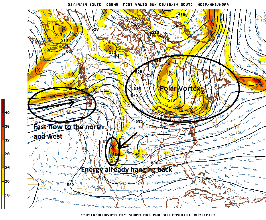
Here is today’s 12z GFS, valid for Saturday evening. We will be looking at the 500mb level, which is right around the middle of the atmosphere.

Today’s 12z GFS valid for Saturday evening — while seemingly favorable for snow at a very broad level — already begins to show why a snow event for our latitude is unlikely.
When taking a look at the pattern in a very broad lens, we see that we have a decent ridge out west, with a potent piece of energy digging towards the Southwest. Additionally, we have a Polar Vortex situated just to our north, which helps to provide cold air. We even have some other energy in the northern stream ready to dive down and phase with the southern stream energy.
However, there are some major caveats. Notice how in the Pacific, the height lines are packed closely together in a zonal, west-to-east fashion. The winds at that level are quite impressive as well, as the wind barb plots indicate. This helps to “push” the ridge eastward, and prevents it from amplifying further. Since this push eastward is occurring on the north side of the ridge, the north side of the ridge gets pushed eastward, as well as the northern stream pattern in general. But the pattern to the south is not getting this same eastward push. This means that while the pattern and energy to the north is getting an eastward push, the energy to the south progresses much slower. Thus, relative to the rest of the pattern, it remains much further to the south and west. With the fast and progressive pattern to the north, and the slower, more amplified pattern to the south, it’s easy to see why lots of energy gets held back.
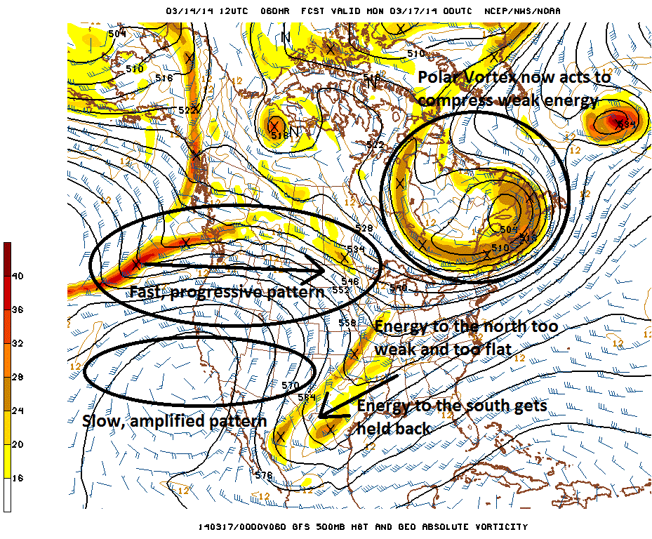
Fast-forwarding to Sunday evening, we can see the effects more clearly.

Today’s 12z GFS valid for Sunday evening shows lots of energy getting held back, thanks to a progressive northern stream, but a slower, amplified southern stream. The weak energy that tries to go east stands no chance against the Polar Vortex.
As we can see, the fast, zonal flow has infiltrated the entire northwestern quadrant of the country, where the flow is extremely fast and progressive. Yet, to the south, the pattern is much slower. This means that energy to the south does not get the “push” eastward that the energy to the north gets, thus it holds back. The fact that the storm does not become one powerful consolidated piece, but instead, a weaker piece with only a little bit of southern stream interaction means that the storm overall becomes a bit weaker. A weaker storm will not be able to amplify the pattern as much downstream. Thus, the Polar Vortex now can act to suppress the storm further — a stronger, consolidated storm would have been able to climb northward with the Polar Vortex in that position, but a weaker storm will get shredded to pieces by it if it tries to go north. The Polar Vortex isn’t the cause of the south trend per-se, but because of what happened out west, it becomes a feature that prevents the storm from climbing northward.
There is still a pretty good moisture source to the south, and some energy to the north interacting with that will initially try to push precipitation northward. And this precipitation from the south running into the cold air to the north with the Polar Vortex will provide lots of lift for precipitation. But without the synoptic forcing from a stronger, consolidated mid-level system, this heavy lifting and precipitation will not be able to reach our area.
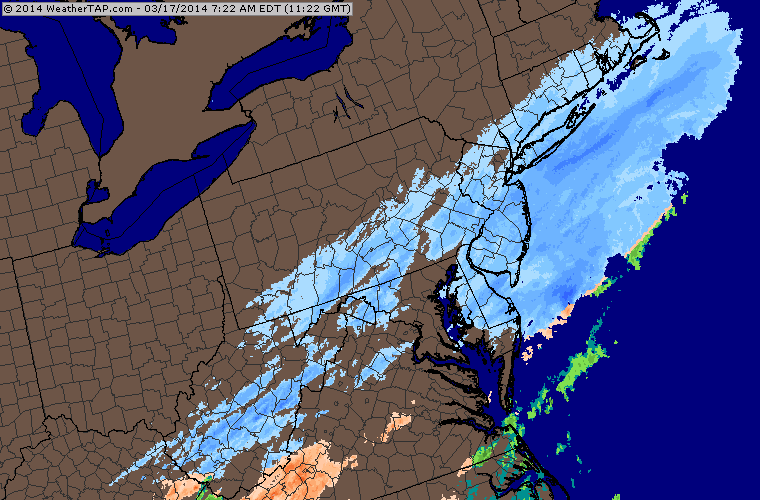
Thus, as of now, our forecast calls for light to moderate snow to reach the southern third of New Jersey on Sunday night, and continue into Monday morning. A few inches of accumulation is possible in these locations. However, from Central NJ and particularly northward, a period of light snow and flurries is possible, but we do not see it accumulating much.
Stay tuned with us over the next couple of days, as forecast changes are still possible. However, as of now, the general pattern and the fast nature of the northern stream in combination with a slow southern stream tells us that the most significant moisture will remain to the south. If the models begin to trend back towards having the energy more consolidated again, and not holding back as much, then a major snow event for our area would become likely again — but based on the reasoning we provided, while not impossible, this scenario is pretty unlikely.
Enjoy your weekend, everyone!
-2")