-2")
Flooding rains give way to storms, warmer air
Widespread flooding rains occurred on Wednesday as a significant plume of tropical moisture surged northward along a frontal zone, which was draped near the area. Heavy rain “trained” northeastward from the Mid-Atlantic states towards New Jersey, New York City and parts of Southern New England. Rainfall amounts over 4″ were widespread, especially in parts of Central and Northeastern New Jersey. The result of prolonged heavy rain was widespread river, creek and poor drainage flooding which resulted in some property damage and a significant amount of road closures.
The rainfall, in fact, was as prolific as it seemed. The 4.97″ which fell at New York City’s Central Park was the 10th highest daily rainfall total in the reporting stations history, and the 2nd highest during the month of April. The 7.85″ which fell during the month of April made it the 6th wettest April in the reporting stations history.
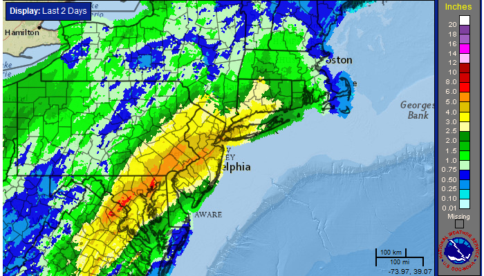
24 Hour radar estimated rainfall totals, courtesy of the National Weather Service.
Thursday will be a different story, as the warm front will have pushed north of the region by mid-morning. South-southeasterly flow initially will keep drizzle and showers around (as well as clouds). But by afternoon, southerly winds are expected to push in a bit of a dry layer in the mid and low levels of the atmosphere. The result will be the potential for some clearing and sunshine. Mid level temperatures will have warmed fairly significantly in the “warm sector” (south of the warm front, but still out ahead of the cold front) — and as a result, temperatures could reach into the 60s and 70s.
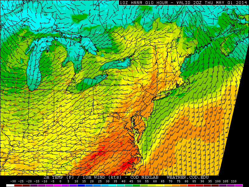
HRRR model forecasting temperatures well into the 70’s Thursday afternoon.
The cold front will approach the area by later Thursday night, however, so the warmth and breaks in the clouds will be somewhat short lived. Showers and thunderstorms are possible as early as mid to late on Thursday afternoon, capable of heavy downpours producing localized flooding at times. No severe weather threat is expected, but the unsettled weather is expected to continue.
Much of the same is expected this weekend. The upper level low which moved through the Central US earlier this week will elongate from west to east over New England. And so while temperatures will still be fairly warm and some sunshine is expected (basically, no washout this weekend) , the upper level low overhead will allow for afternoon showers and thunderstorms on both Saturday and Sunday.
Leave a Reply
Want to join the discussion?Feel free to contribute!