Increased humidity, severe storms this weekend

Low clouds have created a bit of a wrinkle in the forecast early Friday morning, owing to a southeasterly flow which developed late Thursday night. The low level inversion allowed for these clouds to push inland and develop, as seen on visible satellite imagery from Eastern Pennsylvania into much of New Jersey and New York. These clouds will eventually thin and break later Friday afternoon, as southwesterly winds take over.

Temperatures, as a result, will rebound with highs expected to reach into the upper 80’s. Rising humidity will also make it feel much more uncomfortable. The atmosphere won’t be able to efficiently mix out — so temperatures won’t rise into the 90’s on Friday and seabreezes may develop. These seabreeze boundaries could serve as a focal point for the development of some isolated storms Friday afternoon.

HRRR model forecasting highs in the 90's away from the coast on Friday, with cooler air near the shore.

HRRR model forecasting highs in the 90’s away from the coast on Friday, with cooler air near the shore.

Read more

Small asteroid, discovered days ago, will pass Earth Sunday

Talk about a close call. An asteroid, designated 2014RC, was discovered just 5 days ago by the Catalina Sky Survey in Tuscan, Arizona. The results were reported to the Minor Planet Center in Cambridge, Massachussets. The discovery came with only a slight bit of alarm, as the orbital elements quickly revealed that the small asteroid would pass safely away from the earth. At the time of its closest approach, the asteroid will be over New Zealand at around 2:18pm Eastern time on Sunday.

The reflected light from the asteroid suggests it is about 60 feet in size — so a small asteroid at that. Still, an impact from such an object could cause significant impacts on our planet. At its closet point, the asteroid will pass approximately 1/10 of the distance from the Earth’s center to the moon, or about 25,000 miles. That asteroid’s magnitude will only reach 11.5, making it virtually unobservable to the unaided eye.

Graphic depicting the path of asteroid 2014RC. (NASA).

Graphic depicting the path of asteroid 2014RC. (NASA).

Read more

PM Update: Pleasant evening, plus other links

As we discussed earlier this morning, today was a much more pleasant and less-humid day when compared with the few before it. Highs in the lower 80’s felt comfortable with lower dew points and resultant humidity values. Tonight will feature much of the same. Fair-weather clouds from throughout the day will fade and mostly clear conditions are expected. Lows will fall into the mid 60’s away from the city, but may remain a bit warmer than that in urban areas.

Tomorrow looks warmer, with highs in the mid to upper 80’s. But there will likely be a developing seabreeze by afternoon due to onshore winds. There’s a lot of other stuff going on in the world of meteorology. So keep reading:’

Humidity drops midweek, but only briefly

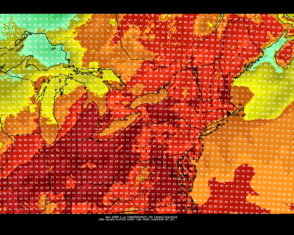
The warmest day of the year occurred in early September, yesterday in fact, as the high in New York City’s Central Park reached 92 degrees. More than the date of the temperature, the actual temperature of 92 degrees being the warmest of the season may be even more shocking. Despite ending around average temperatures for meteorological summer, this calendar summer has featured a peculiar lack of 90+ degree days in NYC (only 5) and no days over 95 F. Granted, there is some variance between Central Park and areas to the west-southwest, but the general idea remains the same.

The humidity is another story — and it made Tuesday’s hot weather even more unbearable. Heat index values approached the upper 90’s with dew points near the 70’s. Generally soupy and humid weather was uncomfortable for anyone who spent a period of time outside. Wednesday, however, features a much less humid and somewhat cooler airmass. Highs in the lower 80’s will feel much more comfortable as a result of this.

NAM model showing highs returning to the upper 80's on Thursday.

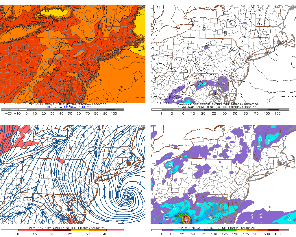
NAM model showing highs returning to the upper 80’s on Thursday.

The cooler and more comfortable airmass will only be temporary, however, as mid level heights will begin to rise ahead of a trough over the North-Central United States. Temperatures at 850mb will noticeably rise again by the end of the week, approaching 20 C by Friday. The warm air will return on Thursday, with highs in the mid to upper 80s, but dew points will remain fairly comfortable.

The sensible weather on Thursday will differ greatly by location. Models agree on the offshore circulation forcing the development of southeast winds near the area shores. This means an increased likelihood of a developing seabreeze — and cooler temperatures near the coasts. The inland push of this seabreeze won’t have any inhibitors, so it may mean a push of low clouds and a breeze even into the interior by evening. Still, inland areas will rise into the upper 80’s before this occurs. Later in the evening, winds will back from Southeast to West-Southwest.

It won’t be until Friday and Saturday when the uncomfortable, humid and sticky air will return. Highs near 90 are expected on both Friday and Saturday as a southerly flow takes over. Dew points are forecast to increase into the upper 60’s to low and mid 70’s by Friday. Heat index values will approach the mid 90’s once again, and a summery feel will return to the air.

Saturday will break the heat and humidity once again, as a disturbance approaches from the west. Showers and thunderstorms, some strong, are expected after temperatures warm toward 90 in the afternoon with uncomfortable humidity values. The volatile pattern, again, looks to continue through the medium range with bouts of heat and humidity followed by showers and storms every few days.