Scattered thunderstorms later today in advance of strong cold front

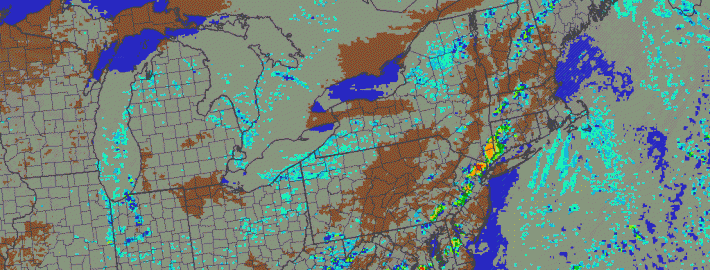
After a lovely fall day on Wednesday, the humidity is back on the rise, as we revert back to summer. The culprit is a storm system and associated strong cold front — the latter of which will be passing through our area on tonight. Immediately out ahead of it, however, will be an increase in southerly winds and a warmer airmass. Often times, a warm, humid airmass in conjunction with a strong cold front can trigger strong thunderstorms. Initially, the threat for severe weather looked pretty high, but as we illustrated in yesterday’s article, there was major uncertainty as to the degree of instability that the atmosphere would hold. As we approach Autumn, high instability values tend to be harder to come by, and as we got closer to today, models gradually backed off on the degree of instability.

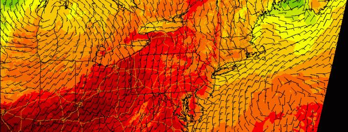
CAPE stands for Convective Available Potential Energy — the higher these values are, the more potential the atmosphere has to support strong, organized lifting for strong thunderstorms. Typically, values around 1,000 J/KG support marginal severe weather, while values 1500 J/KG and higher are more likely to support severe weather. With our area hovering only around 500 J/KG, it will be hard to expect much in the way of severe weather. That being said, this cold front will pack quite the punch with potent dynamics. This will allow for strong wind shear — in the order of around 40 knots — from the surface through the middle of the atmosphere. This means that any thunderstorm that does form could still produce strong wind gusts. Notice how further to the south, the CAPE values are higher, but the wind shear values are much lower — there is no truly impressive juxtaposition between the instability and the wind shear that is often necessary for widespread severe thunderstorms.

Read more

X Class solar flare could produce bright aurora

Two CME’s (Coronal Mass Ejections) from the sun during the last two days have astronomers brimming with excitement. And although the details aren’t totally certain, the earth-directed nature and magnitude of the solar flares have photographers racing for their cameras in hopes of capturing the elusive aurora borealis.

At 1:45pm today, an X-Class (strongest level) solar flare occurred — right on the heels of an M Class flare from Tuesday. Sunspot AR2158 is the culprit. A geomagnetic storm watch has been issued as a result of the Tuesday ejection from the sun. That  flare, despite being weaker than Wednesdays, was long duration — lasting almost 6 hours. During the last few weeks, multiple weaker CME’s have produced auroras throughout the world. The incoming aurora could be brighter, last longer, and extend farther south from the poles than its predecessor.

Read more

Strong storms possible with big cold front Thursday

A significant cold front moving through the Central United States will approach the region late on Thursday evening, bringing a wind shift and drop in temperatures both aloft and at the surface. The cold front is associated with a major mid level disturbance, which will shift from the North Central US into Southeastern Canada. As the front shifts through our region, moderate instability and favorable wind fields could support the development of strong/severe thunderstorms.

The Storm Prediction Center has placed parts of the area in a Slight Risk for severe thunderstorms on Thursday afternoon and evening, citing a risk for strong winds. In addition to the winds, unseasonably high precipitable water could support heavy rain and flooding in any storms that shift through the area Thursday evening. But the severe weather threat isn’t as straightforward as it may seem.

Read more

Morning roundup: More sun, a bit warmer today

Onshore winds and cooler temperatures made Tuesday a bit of a dreary day, especially in the evening. Although a developing coastal storm remained offshore, some bands from the system rotated inland and brought drizzle and sprinkles to the coastal areas of New Jersey and New York Tuesday Night. Decreasing moisture in multiple levels of the atmosphere on Wednesday will lead to improving conditions in much of the area, although clouds and a shower cannot be ruled out. Warmer temperatures are expected, in general, with highs in the 80’s.

A developing storm system in the Central United States will bring changing weather to our area by Thursday. Winds will shift from east/northeast to southerly by Thursday afternoon, ushering in much warmer air and allowing for an increase in humidity. A strong cold front eventually will approach the area by Thursday evening.

Read more