-2")
Warming trend continues, heavy rain on Thursday
The previously chilly airmass this weekend has moved out of the area and has been replaced by much warmer and humid conditions. This is in response to an area of high pressure moving out to sea, giving us southerly winds on its back side. Additionally, a storm system is developing in the Plains, which is also forcing warmer air out ahead of it. Fortunately, most of that rain should hold off until Thursday. Until then, temperatures will continue to warm well into the 70s this week.
With the abundance of southerly flow, a good amount of moisture has propelled into the area, helping to generate clouds. There is still no large-scale storm-system, so we do not expect rain the rest of today and tonight — except for a few patches of drizzle here and there. With the cloud cover, temperatures will be much warmer tonight, as they will hover around 60 degrees. A potential hazard is that patchy fog will be developing this evening and tonight, so it may be good to take some extra time for any commute tonight.
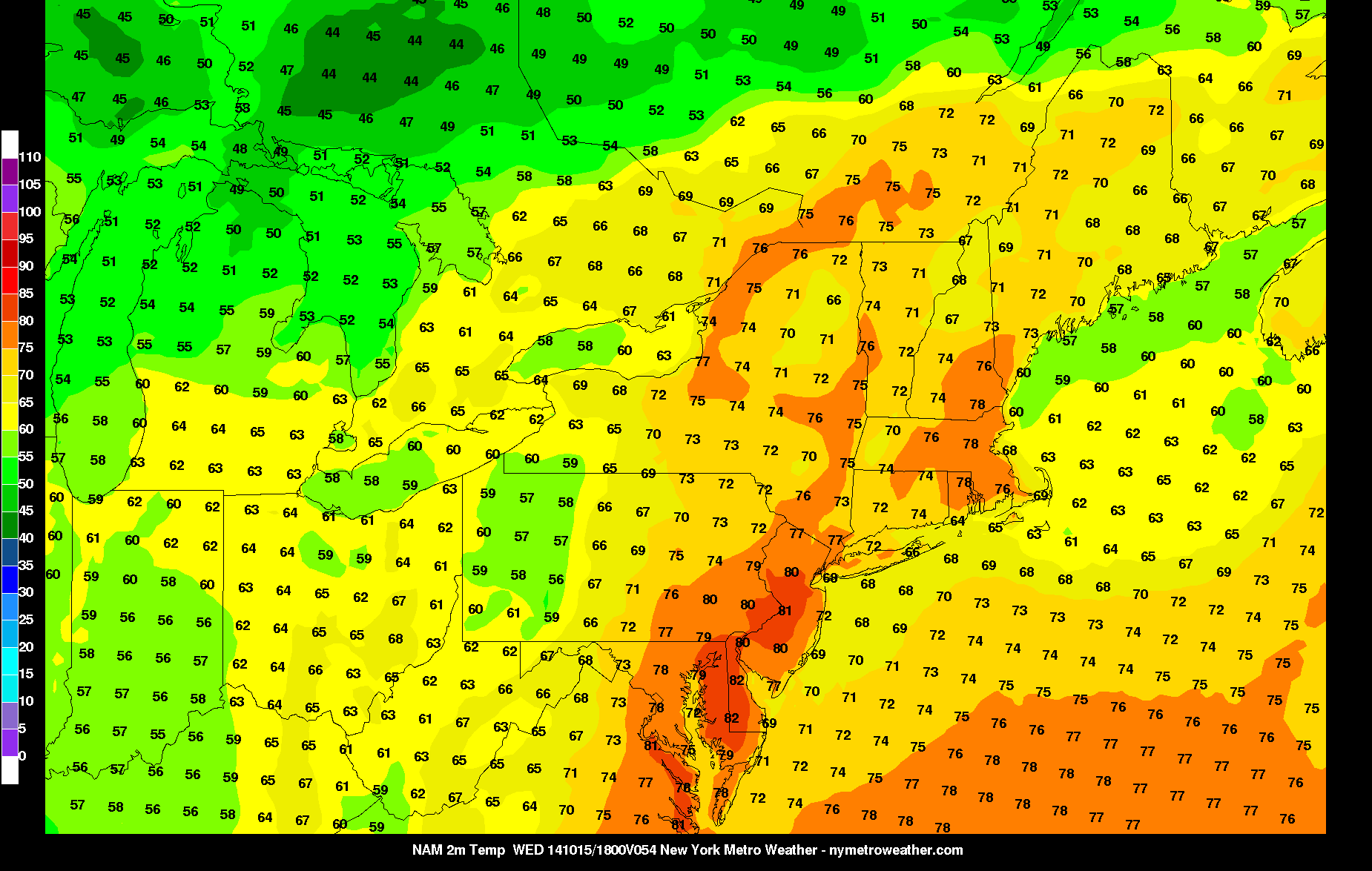
Today’s NAM Model valid for 2:00pm on Wednesday afternoon shows temperatures warming well into the 70s, with some spots hitting 80 degrees.
Tomorrow will still feature some clouds, but will also have sunshine — overall, a partly sunny day, with temperatures generally in the mid to upper 70s, with a few spots approaching 80 degrees! Clouds should linger for tomorrow night, and in this warm airmass, that will allow temperatures to hover in the mid 60s. This is about ten degrees warmer than temperatures were on Saturday afternoon.
If the clouds don’t increase too quickly tomorrow night and Wednesday morning, then Wednesday has the potential to eclipse 80 degrees in many spots. Otherwise, southerly winds will persist and skies will remain mostly cloudy, and these clouds may ultimately keep many areas in the upper 70s. There is the slight chance of a light shower as the day goes on, due to the aforementioned developing storm system in the Plains finally approaching us. On Wednesday Night, the chances of rain will continue to increase, and with the warm airmass, even a few rumbles of thunder are possible during the overnight.
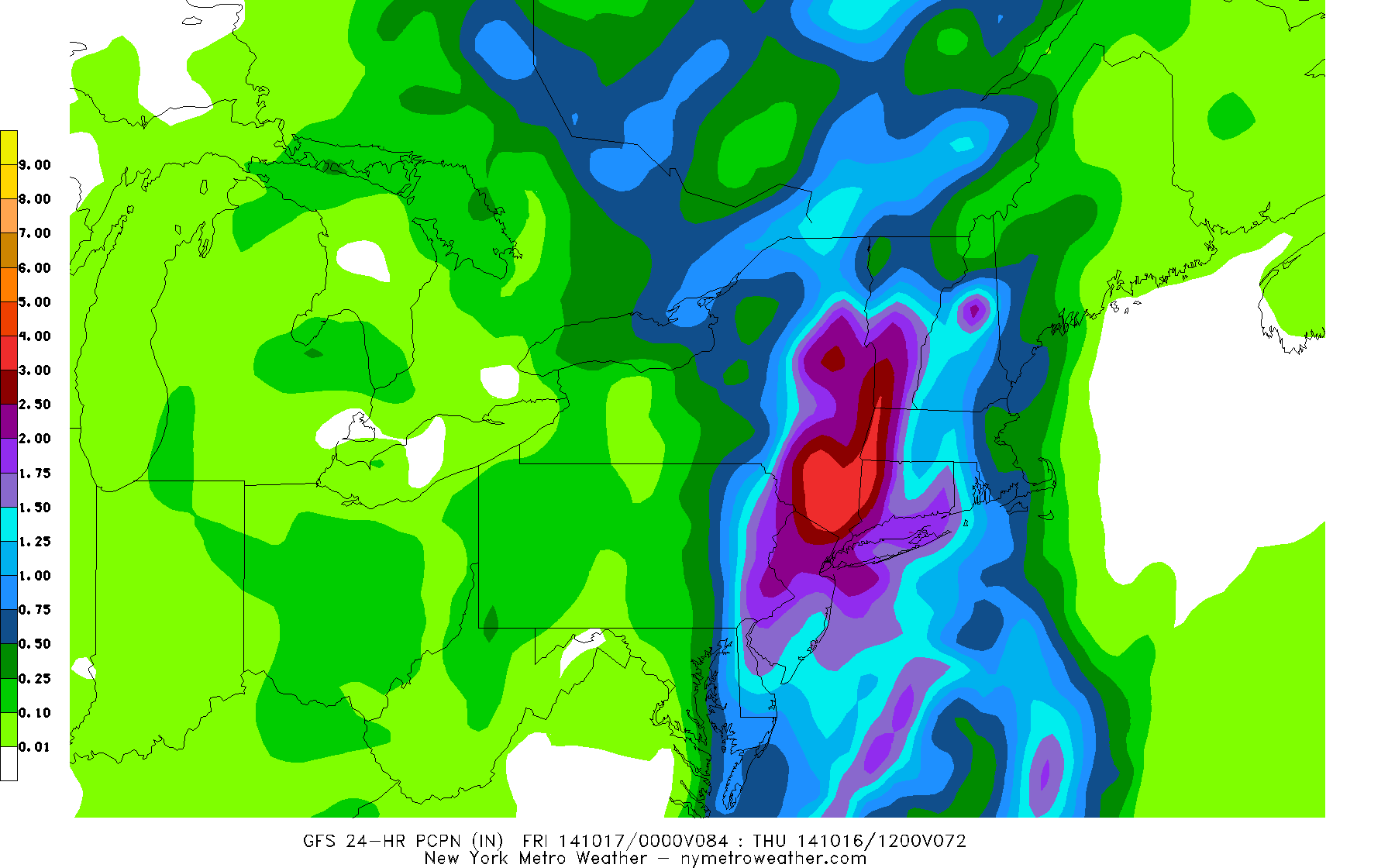
Today’s 12z GFS valid for 8:00pm on Thursday night shows 24-hour rain totals in excess of 1.5″ in many locations.
There is still uncertainty regarding the timing of the heaviest rainfall, but as the storm system passes to our northwest, there will be a large southeasterly flow off the Atlantic Ocean, providing plenty of moisture for a moderate to heavy rainfall event. It may not be as hit-or-miss in nature as some of the past rainfall events, either. From Wednesday night through Thursday evening, some locations could pick up between 1.5 and 3″ of rain, though it is still a bit early to nail down the details. Thursday in general, though, will be a very unsettled day.
The storm system should clear the area by Friday, and temperatures will return to seasonal levels.
Leave a Reply
Want to join the discussion?Feel free to contribute!