-2")
Warmup this week, followed by rain on Thursday
In the wake of a departing Nor’Easter and heavy snow in parts of coastal New England, it was very chilly and windy this afternoon. Temperatures will fall through the 40s this evening strong winds. The National Weather Service has issued a Wind Advisory for SW CT, NYC, and Long Island, for northwest winds between 20 and 30mph, and gusts up to 45mph. Winds will still be strong in NJ, but probably around 10mph weaker on average.
This cold airmass will also lead to very chilly temperatures tonight, with lows generally in the low 30s. The strong winds may keep frost to a minimum in immediate coastal areas and NYC, though interior areas in NJ who have not already had their growing season end may have theirs end tonight.
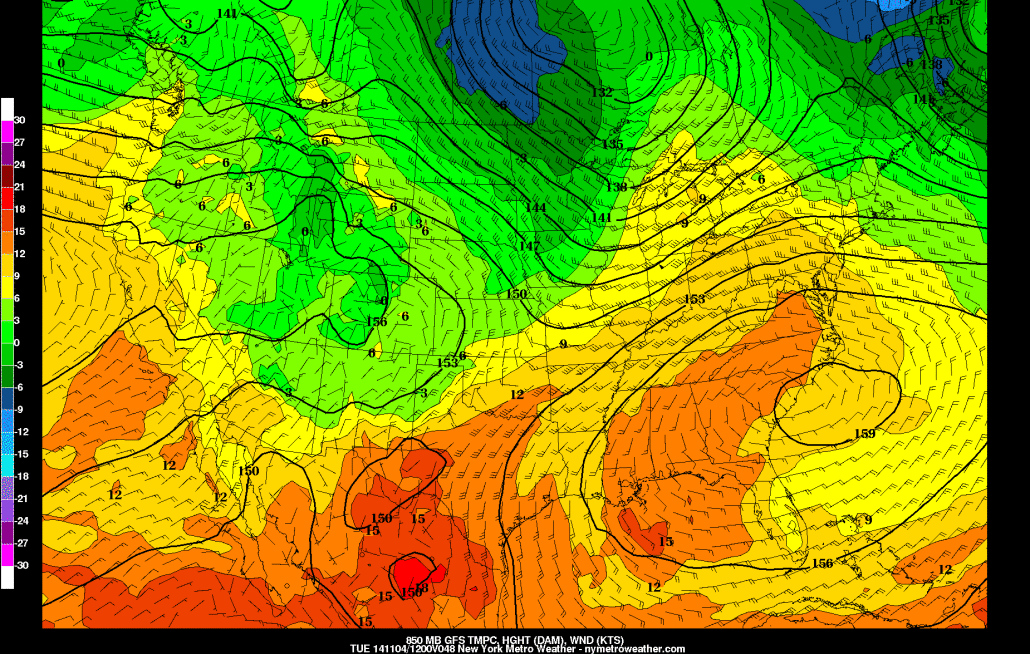
Fortunately, however, despite this cold airmass, it will quickly be on the way out. In fact, our November Outlook we issued on Tuesday calls for a warm start to the month. This is because there is no high-latitude blocking to keep the cold airmass in-place, and it will be replaced by a warm airmass to our west and south, as evidenced in the above featured image. The middle and latter part of November could cool off to below average temperatures — even more-so than originally thought — but that’s a different article for another time.
As the trough moves out and the ridge moves in, winds will shift from the northwest, to the west for tomorrow. Considering the airmass to the west is pretty warm, and westerly winds create downsloping off the Appalachians, this leads to a warming trend. Tomorrow should feature mostly sunny skies, breezy conditions but not as windy as today, with high temperatures around 60.

Today’s NAM Model valid for tomorrow evening shows a strong westerly flow at 850mb, leading to warm air advection and downsloping. This means that tomorrow should be 10-15 degrees warmer than today.
With the warmer airmass moving in, tomorrow night will not be as chilly as tonight. Temperatures will fall into the mid 40s in the city, but with clear skies, diminishing winds, and high pressure moving in, suburbs will experience good rational cooling conditions, and thus should still fall into the upper 30s.
Moving forward to Tuesday, winds will be shifting to the southwest, as a ridge continues to move in towards the area. This means that highs should reach the mid 60s, with mostly sunny skies and much calmer winds.
On Wednesday, the ridge will be getting squeezed a bit as a disturbance moves through Canada. Additionally, rigorous energy will be diving down into the Plains, which will be our next storm system. Fortunately, being on the east side of that storm will lead to strong southwest flow in our area, and yet another warm day, with temperatures in the mid 60s again. High clouds will be on the increase as the day goes on.
The exact timing for when the rain moves in is uncertain, but regardless, Wednesday night will be mostly cloudy with the chance of showers, as more warm air advection moves in out ahead of the system as well as some lifting in the atmosphere. The highest threat for rain, however, will be on Thursday and Thursday night. The storm system will be initially developing in the Ohio Valley, with secondary redevelopment in the Mid-Atlantic.

Today’s GFS model valid for Thursday evening shows a developing storm system in the Ohio Valley, with a 110 + knot jet streak. This leads to amplification of the weather pattern, and lifting in the atmosphere, leading to heavy rain on Thursday and Thursday night.
This storm will most likely not be a Nor’Easter, since it won’t be deepening off our coastline and bringing northeast winds. Because of this, it we will not have the same chilly, raw conditions that we saw on Saturday. Instead, temperatures will generally be in the 50s to around 60 with periods of heavy rain and strong southerly winds.
Once the storm system moves out, chillier temperatures will be on their way back Friday through Sunday, with high temperatures generally in the upper 40s to low 50s. Friday may still have some lingering clouds and showers, but Saturday and Sunday look to be mostly sunny. Similar to today, Friday and particularly Saturday may be quite windy, given we will be on the periphery of the departing storm system and in advance of high pressure moving into the area.