-2")
Rain likely tonight and tomorrow, but not a washout
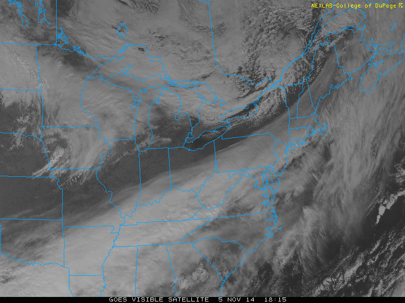
Warm and moist air continues to stream into the region as a strong southwest flow throughout the atmosphere has taken over. These southwest winds are on the leading edge of a storm system that is developing in the Ohio Valley, and will bring us some light rain tonight, and periods of moderate rain tomorrow.
What had initially looked like a much bigger rain event has toned down somewhat on recent guidance. This is for two reasons:
1) The secondary redevelopment is a bit too late and the storm will be somewhat disorganized at our latitude. It will not truly get going until it’s to our north.
2) The track of the system looks to be directly over NYC. This means that the heavier stratiform precipitation should be west of the city, but the warm conveyor belt rains with the low-level jet should be east of the city.
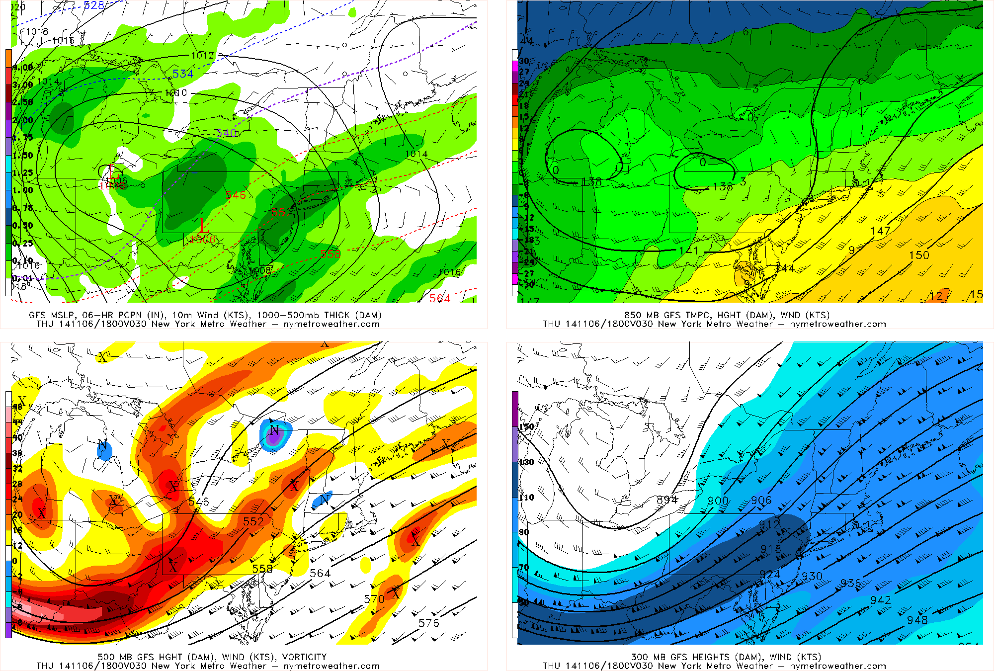
Today’s GFS model shows rain moving in out ahead of a developing storm system. However, despite the rigorous set-up in the middle and upper levels of the atmosphere, the storm remains largely disorganized at this point.
Warm air advection will strengthen tonight as the storm system approaches, which will lead to some overrunning light to moderate rain out ahead of the system. This will start during the overnight tonight and last through tomorrow morning. Tonight’s temperatures should hold around 50 or in the low 50s, and will rise to around 60 tomorrow afternoon, due to the southerly winds.
Once we reach tomorrow afternoon is where the uncertainty begins to lie. A small margin of error in the track of the storm could either mean that a lot of our area is dry-slotted, or still experiences some periods of rain. That being said, it does appear quite possible that the rain could become quite scattered in coverage at best during parts of the afternoon for the immediate NYC area.
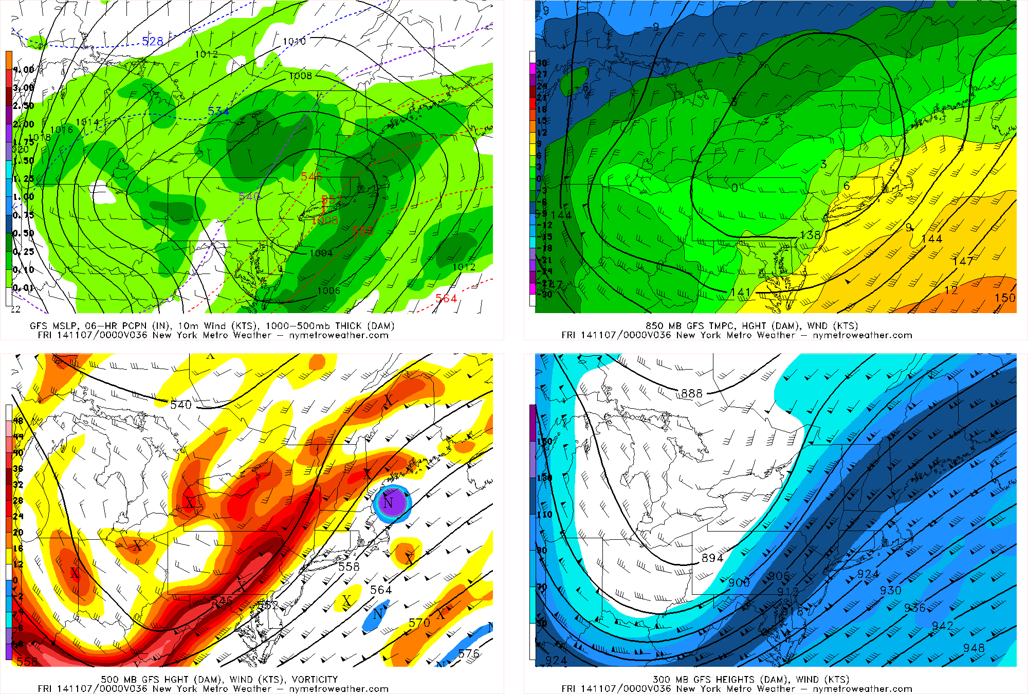
Today’s GFS valid for tomorrow evening shows the storm system passing directly over our region, which may lead to a dry-slot in or around the city.
What may end up happening is that tomorrow evening, the warm conveyor belt will strengthen and give areas east of NYC a brief bout of heavy rain — this would more likely be relegated to Suffolk County, though it could clip Queens and Nassau as well. Areas in and around NYC may only see scattered showers and some periods where it’s barely raining at all. That being said, a small shift in the track could mean a bit more rain for NYC — but it’s pretty likely that the strongest of the heavy warm conveyor belt precipitation will be east of NYC. Heavier stratiform precipitation will be developing in Upstate NY and perhaps parts of NW NJ and move through interior New England, giving Vermont, New Hampshire, and Maine a few inches of snow.
Overall, around a quarter inch to a half inch of rain seems likely for most of NJ and NYC, with perhaps slightly more in Queens and Nassau County, and closer to three quarters of an inch of rain in Suffolk County. There could be localized higher amounts — particularly in heavier downpours in the warm conveyor belt tomorrow evening — but overall, this does not appear to be a washout with much heavy rain.
Winds will be gusty out of the south at times, particularly on Thursday night with the passage of the low-level jet. The strongest winds will be on E LI and CT, where gusts could reach 30mph. With the strong low-level jet advecting moisture into the region, there is the outside chance of enhanced instability developing in Central and Southern NJ, and even parts of Long Island. This could cause a rumble of thunder, as well as 40-50mph winds to mix down to the surface. Any severe weather will most likely only affect Delaware, Maryland, and Virginia.
After the storm passes, the winds will shift to the west, and things should dry out after midnight. Low temperatures will be in the mid to upper 40s.
Leftover energy on the back side of the storm will keep clouds around for Friday, but any scattered showers should remain to our west. Temperatures should generally be in the mid 50s on Friday.
Colder temperatures are more likely to settle in on Saturday, as cold air advection strengthens behind that leftover energy. Temperatures will not get out of the 40s during the day.

Today’s GFS ensemble mean valid for Tuesday shows an arctic airmass building in southern Canada and sliding towards the US. Out ahead of it, though, may be a brief moderation in temperature.
Temperatures will slightly modify afterward, but the airmass we will be in is generally colder, so a significant warmup should be muted. A more classic El-Nino-like pattern will be taking shape, with a strong Aleutian low greatly pumping up a ridge downstream — leading to a strong ridge from the west coast, all the way through the NW Territories and into the Arctic. This will send the Arctic Oscillation into the tank (strongly negative) and allow for Arctic air to be sent southward. Initially, however, we will be southeast of the airmass — being on the leading edge of this airmass will lead to southwest winds, and perhaps a decent warmup on Veteran’s Day.
By the time we get to the Wednesday-Friday timeframe of next week, most of the eastern half of the country may be experiencing its first Arctic outbreak of the season.
Typhoon Nuri continues to impress:
One of the reasons for this pattern change will be from the incredibly strong Typhoon Nuri. It has been an absolute beauty to view on satellite, and is one of the strongest storms to form on our planet this year.
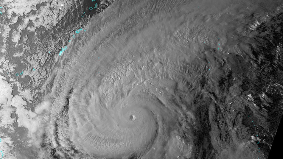
Super Typhoon Nuri maxed out at 180mph on Monday. It is currently weakening, but may become a monstrous extratropical storm near Alaska over the next few days. Image from the University of Wisconsin/CIMSS.
Currently, the storm is recurving to the east of the Japan Islands. While the storm will not remain a Super Typhoon much longer, some computer models have been forecasting Nuri to become an extratropical cyclone with pressures below 920mb! Assuming it maintains its forecast track to the western part of Alaska, it would be one of the strongest storms that area has ever experienced.
Recurving Typhoons — especially ones of this magnitude — often create strong downstream rippling effects to the weather pattern. They help to transport heat and energy towards the northeast Pacific, which in turn greatly amplifies the jet stream. But because of the incredibly strong energy, not only does the jet stream become amplified, but it still has very fast speeds — this amplified and high speed combination to the jet stream in the northeast Pacific leads to a highly amplified, highly energetic weather pattern downstream.
This often allows for large cold airmasses in the Arctic to slide southward, as well as generate storminess. Thus, it is becoming fair to say that as we approach the middle of November, the weather pattern looks to become colder and stormier.
Trackbacks & Pingbacks
2otherwise
Comments are closed.