-2")
NWS forecasting 5-6 feet of lake effect snow in New York
As an arctic airmass shifts throughout the United States, the Lake Effect snow “machine” will be turned on for the first time this season. And it’s coming in with a bang. The combination of extremely cold air aloft, the surge of cold air advection, and warmer air/moisture along the Great Lakes is leading to the potential for epic amounts of snow. Extremely heavy bands of snow sat south of Buffalo and near Watertown, New York this morning producing snowfall rates of 3-5″ per hour . The bands were visualized on regional radar, barely moving but fluctuating somewhat from north to south.
Meanwhile, the National Weather Service is forecasting bands to persist over the next day. Instability within the bands of heavy snow is allowing for lightning and thundersnow — a rare phenomena which actually does occur in New York City from time to time as well. But the National Weather Service in Buffalo has much bigger problems to deal with — some areas have already seen 36″ of snow accumulate from the band of heavy snow, and it isn’t expected to move a great distance until later tonight when a mid level trough swings through and changes the flow orientation. By that point, the potential exists for some areas to receive up to 70 inches of snow. That’s right — seventy inches.
The National Weather Service discussion from Buffalo, NY describes the situation well:
...INCREDIBLE LAKE EFFECT SNOW EVENT CONTINUES TO UNFOLD TODAY WITH
A TIGHT NORTHERN GRADIENT AND NEAR BLIZZARD CONDITIONS THROUGH
TUESDAY EVENING...

REGIONAL RADARS AND GROUND TRUTH REPORTS THIS MORNING TELL THE STORY
OF THE LAKE EFFECT EVENT THAT CONTINUES TO UNFOLD THIS MORNING.

OFF LAKE ERIE...RADARS DISPLAY A STRONG BAND OF LAKE EFFECT SNOW
ALONG THE LONG FETCH OF LAKE ERIE...WITH SOUTHWEST WINDS DRIVING
THIS BAND INLAND OVER AREAS FROM SOUTH BUFFALO TO THE SOUTHTOWNS AND
EASTERN SUBURBS. THE NORTHERN EDGE OF THE BAND IS RIGHT NEAR
DOWNTOWN TO DEPEW EAST TO NEAR BATAVIA. BASED ON REPORTS THIS
SNOWBAND IS EXHIBITING SNOWFALL RATES OF 4 INCHES PER HOUR. THERE
WERE SOME RUMBLES OF THUNDER LAST NIGHT...AND THOUGH LIGHTNING
ACTIVITY HAS DIMINISHED...THE RISE IN EQUILIBRIUM LEVELS ALONG WITH
SOME SUGGESTION FROM MESO SCALE MODEL REFLECTIVITY...WE AGAIN SHOULD
SEE LIGHTNING AND HEAR SOME RUMBLES OF THUNDER WITHIN THE SNOWBAND
TODAY.

A 240 FLOW WILL LIKELY KEEP THIS BAND OF SNOW NEARLY STATIONARY
THROUGH THE MORNING HOURS...WITH JUST SOME MINOR (FEW MILES) OF
WIGGLES NORTH AND SOUTH. EXPECT THE HEAVIEST SNOW ACCUMULATIONS TO
FALL JUST TO THE SOUTH OF ROUTE 33 THROUGH THE EARLY AFTERNOON
HOURS. BASED ON REPORTS THIS MORNING OF SOME AREAS FROM SOUTH
BUFFALO TO LANCASTER OF NEAR 40 INCHES ALREADY AND THE FACT THAT THE
BAND WILL NOT MOVE MUCH THROUGH LATE AFTERNOON...WE HAVE INCREASED
STORM TOTALS TO AROUND 70 INCHES IN THE HARDEST HIT AREAS.
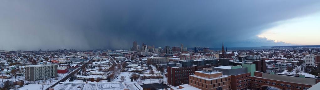
While the lake effect snow event continues, many are taking to social media to disseminate their pictures and accounts of the incredible snowfall amounts. Some have even taken to the heights of buildings in Buffalo to post pictures of the incredible lake effect snow band as seen from just a few miles away.
@NWSBUFFALO from the Village of Lancaster. pic.twitter.com/49r2XSc43f
— Megan Wagner (@MeganMWagner) November 18, 2014
Incredible. RT @katejendrasik: #WGRZsnow Here in Cheektowaga right by John F Kennedy High School! pic.twitter.com/5JU5P4Kjy5
— Tim Ballisty (@IrishEagle) November 18, 2014
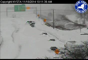
Cars buried in lake effect snow, from the New York Thruway camera.
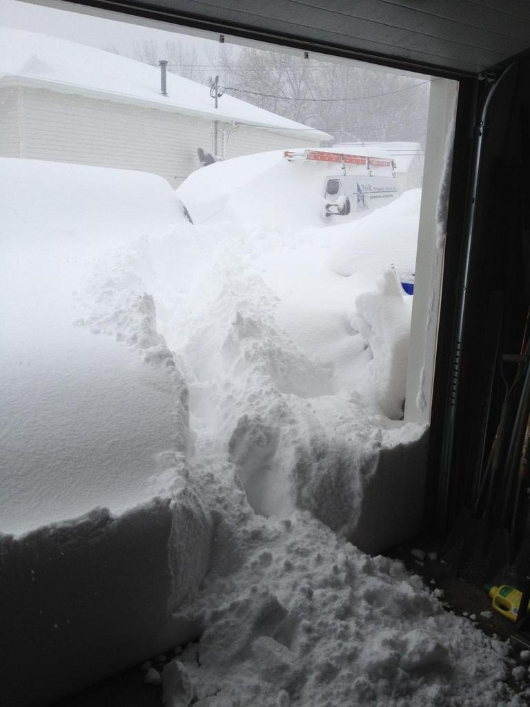
Lake Effect Snow accumulation south of Buffalo, courtesy Twitter User RMGentz
Lancaster, NY .. Ridiculous. RT @aaronwivb: Pics just keep pouring in, each one more incredible than the next. #Snow pic.twitter.com/jjvaYXzBnR
— Ari Sarsalari (@AriWeather) November 18, 2014
10:00am and I measured 3 1/2' in the driveway. Don't even know where to start!! @JimCantore #WGRZsnow @JenStanonis pic.twitter.com/YSdPtjLfGY
— Heather Pierce (@h_pierce) November 18, 2014
@JimCantore Hamburg, NY pic.twitter.com/wJdxvy5niF
— mike (@MikeBacon1226) November 18, 2014
"I am coming for you, Buffalo" LES pic.twitter.com/beEjryCV19
— Mark T. Branden (@mtbranden) November 18, 2014
South Buffalo. Posted by Melanie Walgate to @news4buffalo FB page. #LakeEffect pic.twitter.com/vw9RgA8ahH
— Tim Ballisty (@IrishEagle) November 18, 2014
Lake Effect Snow, quite simply, is produced when cold winds blow over warm waters. The bands of snow form as energy is gained and water vapor picked up, with snow forming and then falling on the leeward shores. Lake Effect bands can move around as a result of mid level winds and shear, and gain/lose intensity based on the moisture fetch and instability in the area as a result of mid level and low level/surface temperatures.
Trackbacks & Pingbacks
2scanning
Comments are closed.