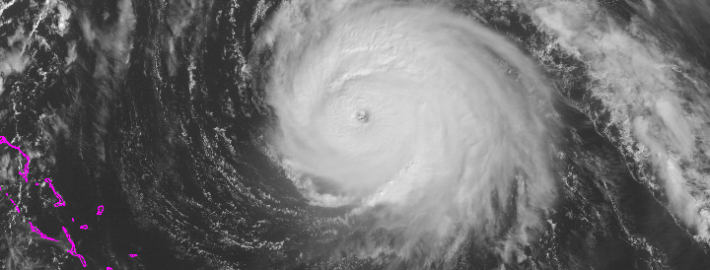
Gonzalo heads toward Bermuda as a dangerous Category 4

Hurricane Gonzalo strengthened into a Category 4 hurricane this morning, and has since strengthened further. Maximum sustained winds within the storm are 145mph as of 11am, with higher gusts. Most concerningly, the system continues to strengthen and organize as it heads northward. The hurricane will eventually take on a slight northeasterly heading, as it moves along the periphery of both an Atlantic ridge to its east, and troughing to its west over the Western Atlantic Ocean.

Most unsettling, obviously, is the forecast track of the system. Models are in good agreement that the storm will make the aforementioned turn, taking the center near or just west of Bermuda during the mid to late afternoon on Friday. This puts Bermuda in a precarious situation — the worst winds will shift to the east side of the system as it makes this turn. Maximum sustained winds are forecast to remain near 130 mph at the time the storm nears Bermuda.

Read more

Forecast: Clearing, cooler behind cold front

A warm, humid airmass surged into the region late on Wednesday ahead of a cold front. As expected, low level moisture moving north aided in the development of heavy rain overnight as lift for precipitation moved through our area. Rainfall totals were moderately high in many locations, but we were able to avoid widespread flooding due to the relatively progressive nature of the system. As the mid level disturbance moved northeastward, drier air moved through  much of New Jersey and toward New York City this morning bringing an end to the steady rain.

On the periphery of this mid level disturbance is a cold front, which will push through the remainder of the area this morning after some additional rains fall on Long Island and Connecticut. Gone will be the southerly winds, and making a return will be drier, westerly winds this afternoon. Mid level temperatures, meanwhile, won’t exactly fall off the table until later tonight. So high temperatures today will still reach into the 70’s.

Read more

Live Blog: Very heavy rain, thunderstorms tonight

Our live blog (below) will be updated throughout the night by our meteorologists as we track the expected heavy rain and thunderstorms. If you’re on our front page, click “read more” to view it.

Read more

Heavy rain, thunderstorms likely tonight into Thursday

An approaching strong cold front, and associated mid and upper level disturbance, will bring heightened chances for rain into the area from tonight into Thursday morning. However, the event will be made more significant by a plume of moisture, surging northward along and ahead of the frontal boundary. Forecast models indicate a strengthening low level jet stream and transport of this moisture. Precipitable water values (the amount of water in the atmosphere) will be high — in the 95th percentile for October.

The moisture will begin surging northward later this afternoon and evening. Forecast models indicate the best lift for precipitation will remain to our west until the latter part of the afternoon. At that point, from west to east, chances for showers and thunderstorms will increase. Initially, downpours will be scattered. But over time tonight, the support for heavy rain will expand and moisture will continue surging northward. Rain will develop from southeast to northwest, with widespread heavy rain likely throughout the area overnight.

Read more