Tuesday roundup: Gonzalo, severe weather, heavy rain

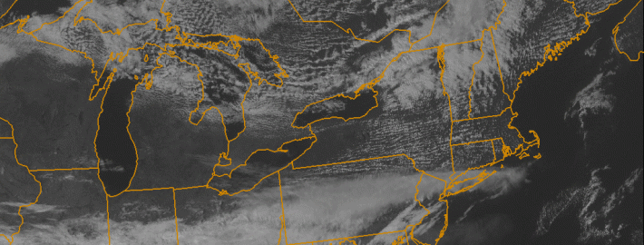
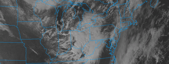
The week began with clouds and drizzle, signaling the arrival of a warmer airmass which has been pushing northward from the Southeast and Mid Atlantic states. But the dreary and drizzly weather won’t take over the forecast on Tuesday. Southerly winds will push some drier air northward, helping to lift the low clouds and fog in place throughout the area. Warmer air will settle in by Tuesday afternoon, with highs reaching the mid 70’s. This will feel noticeably warmer than the past several days, especially considering the cooler than normal air and then drizzle/foggy weather which was in place.

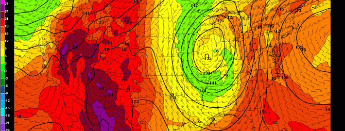
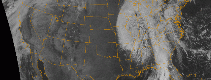
The warmer weather won’t last long. An approaching storm system, currently bringing severe weather to the Central and Southeast United States, will shift northeastward toward our area later this week. With it will come a major cold front, and a surge of moisture aiding in the development of heavy rain and thunderstorms. Although forecast models are still a bit inconsistent, the general idea is that a period of heavy rain will race through the area on Thursday. Rainfall totals of 1-2″ could be widespread, with an onshore flow providing not only hazardous marine conditions but also some coastal flooding.

Read more

Warming trend continues, heavy rain on Thursday

The previously chilly airmass this weekend has moved out of the area and has been replaced by much warmer and humid conditions. This is in response to an area of high pressure moving out to sea, giving us southerly winds on its back side. Additionally, a storm system is developing in the Plains, which is also forcing warmer air out ahead of it. Fortunately, most of that rain should hold off until Thursday. Until then, temperatures will continue to warm well into the 70s this week.

With the abundance of southerly flow, a good amount of moisture has propelled into the area, helping to generate clouds. There is still no large-scale storm-system, so we do not expect rain the rest of today and tonight — except for a few patches of drizzle here and there. With the cloud cover, temperatures will be much warmer tonight, as they will hover around 60 degrees. A potential hazard is that patchy fog will be developing this evening and tonight, so it may be good to take some extra time for any commute tonight.

Read more

Unsettled autumn weather this weekend

It has been a busy week.Strong thunderstorms which produced damaging winds in New England, a blood red moon and lunar eclipse, and noticeable temperature swings have all made news over the past several days But, finally,some tranquil weather settled into the area on Wednesday and Thursday when highs reached the 70’s and sun was plentiful. The weekend, unfortunately, won’t follow the same path. An approaching disturbance is likely to bring unsettled weather to the area from later tonight through Saturday.

High clouds from the associated system have already filtered into the area this afternoon, in response to the first disturbance moving through the Ohio Valley. This lead disturbance will bring continued cloudiness, as well as a chance of showers to the Mid-Atlantic and southern portions of our area…including Southern New Jersey. This lead disturbance will remain relatively weak and slide offshore, so we aren’t expecting a washout by any means on Friday.

Read more

Strong thunderstorms with isolated tornadoes tonight

A very interesting meteorological setup for severe weather looks to unfold tonight. A large blocking pattern in the Arctic has forced a large trough to dig into the Midwest, and this will eventually swing through to our area, yielding a potent storm system to our northwest. Although it is often much easier to get thunderstorms during the summer when airmasses are warmer, storm systems are usually stronger during the Autumn, as there is often a larger difference in temperature — or a battleground — for a storm to form. Considering this, plus the fact that in early October the Atlantic Ocean is still quite warm, it becomes much easier for severe weather to be supported near the coast. The strong storm system will serve to bring warm, moist air from the Atlantic Ocean, yet also provide colder temperatures aloft, generating plenty of instability. Additionally, instead of the rising air for showers and storms coming from sunshine heating the ground, we are able to generate forcing for lift from that strong storm system. This gives us the basic foundation for severe weather tonight into Wednesday morning. But this situation remains quite unique.

Arguably the most impressive facet of this potential threat is the strong winds just above the ground. When winds change direction (clockwise) from the ground and up, as well as greatly increase in speed, that is when strong wind shear is created, which supports rotating thunderstorms, capable of producing strong wind gusts and isolated tornadoes. Given that surface winds will be out of the southeast, and winds just above the ground will be in excess of 50 knots out of the southwest, plenty of wind shear is generated. When this is combined with instability, those rotating updrafts can be lifted into thunderstorm clouds, and severe weather can be realized. Without the instability to lift rotating updrafts into thunderstorm clouds, thunderstorms greatly diminish in coverage. Lots of recent model data, however, shows a good combination of potentially rotating updrafts and instability, which piques our interest.

Read more