PM Update: Cloudy, damp behind backdoor front

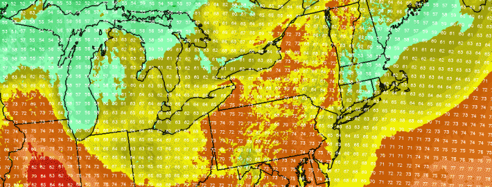
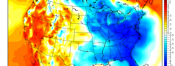
Ah, that phrase again. Backdoor cold fronts often manifest themselves in New England and the Mid Atlantic during the transition seasons of Autumn and Spring. This year, of course, is no exception. We had plenty of them in the Spring, and this is our first of Autumn. We even wrote a detailed breakdown of how they work, and why they affect our area. Regardless, a backdoor front associated with a mid level disturbance overhead slipped past the region yesterday, and we’re feeling the full effects of it today with cloudy and damp weather.

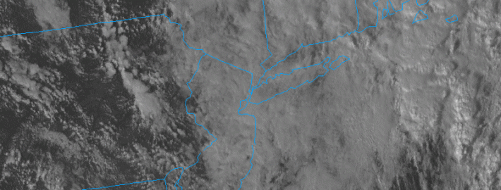
A weak low pressure system off the coast is bringing enhanced rainfall to parts of Southern New England, Eastern Long Island and Connecticut tonight. The best forcing and lift for rain will remain to the east of the areas, but periods of more steady rain and showers are possible through tonight and into Thursday. Tonight, as a result, will remain quite cool and damp. We suggest bringing a jacket if you’re headed out. You may want to carry an umbrella along, too, just to be safe.

Read more

HRRR model goes operational at NOAA

Our forecasters have used and reference the HRRR model for a number of years now. You’ve likely seen it referenced in our posts, displayed on our graphics, and shared on our social media accounts. Our forecasters have used it for near-term forecasting, even in mesoscale events such as thunderstorms and heavy snow bands. Yesterday, NOAA finally let the HRRR out of its box with the model becoming officially operational. The model will run hourly on the NOAA server from now on, with faster graphic and product production. The model is expected to become a tremendous source of information not only for forecasters, but for hobbyists and public alike.

Known formerly as the High Resolution Rapid Refresh model, the model runs every hour and produces forecasts at 15 minute intervals, extending out to 15 hours. A tremendous amount of forecast products are produced, ranging from simulated radar to frontogenic forcing at multiple levels. The model also is a significant upgrade in resolution when compared to the more popular NAM model, and even increases resolution by four times over it’s closest companion, the Rapid Refresh (RAP) model, which had been the NOAA’s only hourly high resolution model running until yesterday.

Read more

High latitude ridge could bring below normal temperatures

High latitude ridging has become a bit of a staple in meteorological terminology over the past several years. Much of this can be attributed to the fact that we’ve seen several record breaking episodes of it. Conversely, we’ve also seen periods which have lacked that blocking, leading to major forecast changes and dramatic pattern evolutions. High latitude blocking, or ridging, occurs when higher than normal heights build into the higher latitudes (here’s a not-so-fancy image of where the high latitudes are defined). This can occur at any time of year, but we’ve seen it in the Autumn and Winter more often over the past several seasons. High latitude ridging and blocking events can be of varying degrees, as well. Some of the less extreme examples, like this upcoming one, can produce mild pattern changes. Other more extreme examples, like the high latitude block that occurred prior to Hurricane Sandy and the Boxing Day Blizzard, can…well, you know.

Nevertheless, without getting overly technical, these high latitude blocks and ridges can “buckle” and slow down the mid and upper level atmospheric pattern. And while much also depends on what’s going on around these blocks, more often than not if they occur on the Atlantic side (Northwest Atlantic Ocean into Greenland), they result in cooler than normal air being displaced to the south of the ridge over Canada. This often leads to cooler than normal air in our region, and this upcoming event likely won’t be an exception to that rule.

Read more

Mid level disturbance leads to epic cloud display in NYC

These NYC clouds weren’t as menacing as they look — we promise. The showers which moved through the area this morning, as a result of a mid level disturbance shifting overhead, created some incredible displays in the New York City area. The surrounding cloud deck made the multiple cloud types even more impressive. Instagram and Twitter users took to their cameras to share some amazing photo’s today — and we’ve compiled some of them below. Chances for showers and an isolated storm will continue today, and a weak coastal storm may bring a period of moderate rain to Long Island and Connecticut tonight into Wednesday.

Read more