Finally! 70 degree temperatures possible this weekend

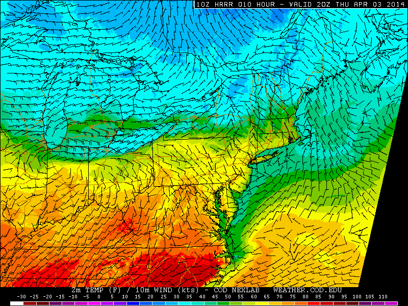
After a long, cold winter which was characterized by below normal temperatures and above normal snowfall, even the slightest sign of spring in 2014 has felt incredibly refreshing. Temperatures this week, so far, have warmed into the 60’s with a noticeable westerly breeze. The cold, freezing nights are becoming a memory at this point as air masses modify and the source of dramatically cold air moves farther away from our area. Things look to improve even further by late this weekend, when a warm southerly flow could warm temperatures into the 70’s.

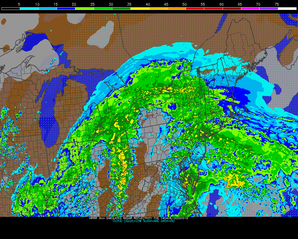
Forecast models have been jumping around  a bit with their exact handling of multiple disturbances moving through the United States during the latter half of this week into the weekend. But recent agreement on the evolution of the pattern lends confidence to the idea that warmer air is on the way by later this weekend. After a front moves near the area on Friday afternoon and slows down a bit, allowing for a period of rain later Friday into Saturday, the front will wash out and weaken by Saturday morning. And so as a storm system develops well to our west over the Central United States, warm southerly winds will usher in milder air that will ultimately bring our temperatures near or over 70 degrees by later this weekend.

NAM model forecasting high temperatures in the mid 60's throughout the area on Saturday, with cooler air near the coast.

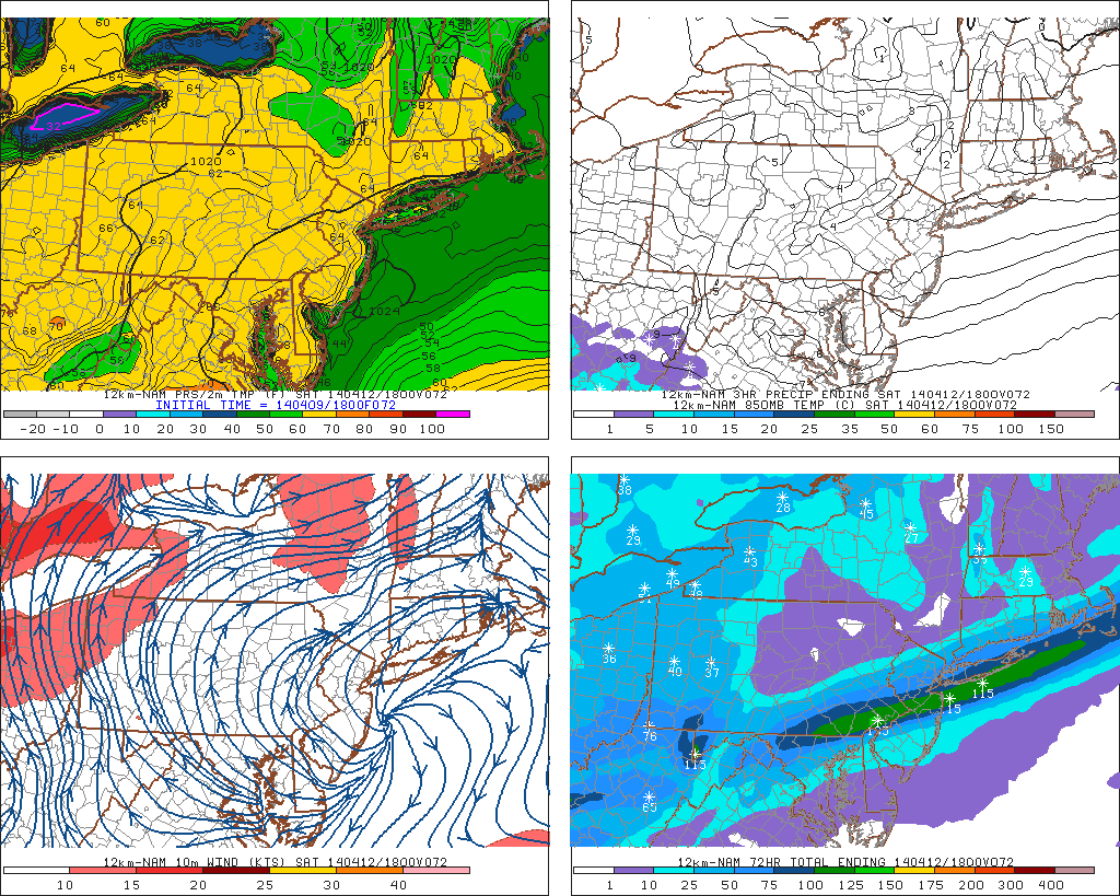
NAM model forecasting high temperatures in the mid 60’s throughout the area on Saturday, with cooler air near the coast.

Read more

Pleasant, warmer weather takes hold through late week

A developing high pressure system will bring increasingly pleasant weather to the area during the middle part of this work week — and despite being in a generally active spring pattern which many disturbances moving through the country, the pleasant pattern looks to hold through at least early next week. Moderating temperatures will the story on Wednesday through Monday — with a brief interruption by a period of rain late this week into the early weekend. But high temperatures will rebound into the 60’s and potentially warmer during the next several days.

A potential wild card in the setup will be the wind direction, especially near the coasts. Cooler ocean waters this time of year can have a major impact on temperatures near the shore. Forecast models are in good agreement that Wednesday will be a true winner of a day with temperatures nearing 60 for highs in most locations and a light west/northwest wind. By Thursday, however, things change as winds turn southerly and a warmer airmass begins advocating into the region. Although marking the start of a warmer trend, the southerly winds inevitably mean a sea breeze or ocean influence along the shores of New Jersey and Long Island.

HRRR model forecasting highs near 60 this afternoon.

HRRR model forecasting highs near 60 this afternoon.

Read more

Spring Wx Awareness: Severe storms, and SPC

Each year, as the atmospheric pattern begins to undergo a transition and wavelengths begin to change, the threat for strong to severe thunderstorms becomes a focus of the meteorological community in New Jersey, New York and Connecticut. Spring, in fact, marks the beginning of “Severe Weather” season in our area — which generally has been known to begin on May 1st. There are obviously severe thunderstorm events outside of that date, but in general the most consistent potential for organized severe storms begins in May and ends in August or September.

Interestingly enough, severe thunderstorms feature some terminology and atmospheric interactions which can be very confusing not only to interpret as meteorologists, but to understand on the public level. Knowing the basics of how organized thunderstorm events develop, and how forecasters attempt to predict and quantify their potential, will help to make things a little less confusing when severe weather season comes around this year.

Thunderstorms can dump tremendous amounts of rain over small areas in a brief period of time.

Thunderstorms can dump tremendous amounts of rain over small areas in a brief period of time.

Read more

Period of heavy rain likely Monday, nice week ahead

The morning began in a bit of a haze — literally — as smoke from a brush fire in Southern New Jersey billowed north/northeastward toward much of New Jersey and the 5 boros of New York City. So if you’re smelling the smoke and seeing the haze this morning, in all likelihood you do not need to be alarmed. Temperatures, on the other hand, started out seasonably today in the 30’s and 40’s and will rebound a bit more into the 50’s by the afternoon hours. But an approaching storm system will end up bringing an end to any pleasant weather by this afternoon.

A low pressure system shifting through the Ohio Valley will bring a warm front and area of enhanced lift for heavy precipitation with it later today. Showers are expected to shift northward towards Southern and Central NJ by late morning, and then into Northern NJ and NYC by early to mid afternoon. If you’re headed out to the Yankees home opener this afternoon, bring an umbrella and rain gear. Although the first pitch and ceremonies likely won’t be a washout, the increasing likelihood of showers and steady rain by mid to later innings suggests things could get a little dicey in terms of potential rain delays or even postponement.

HRRR model showing heavy rain in the area this evening.

HRRR model showing heavy rain in the area this evening.

Read more