Live Blog: High impact coastal storm through Thursday

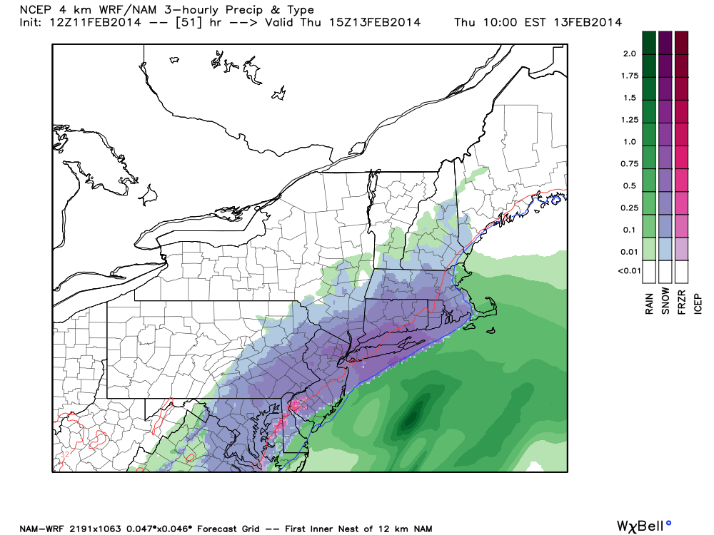
A high impact storm system will affect the area beginning later Wednesday evening, and continuing throughout much of Thursday. Significant amounts of snow, periods of rain and sleet, gusty winds and coastal flooding are all expected hazards. Wednesday night a strong storm system will develop off the Carolina coast, owing to a powerful mid and upper level trough and shortwave. Phasing disturbances aloft will eventually reach the East Coast, which will help shift the coastal system  north and eventually northeastward from the Mid Atlantic to the shores of New England.

With significant impacts expected, we have opened up our live blog for discussion throughout the overnight period beginning at 7:00pm February 12th, 2014. Throughout this time, our meteorologists will check in and continue to update the live blog (and the website products, of course) with information. Even better, the live blog will feature our staff’s thoughts on the event as it is unfolding. This way, you’re never in the dark when it comes to the forecast or the storm which is evolving. Keep it right here tonight and during the storm on Thursday. We have included some handy links to our recently issued products below, followed by the live blog below that. Note: We are using a brand new software, so bear with us if there are any kinks (and let us know, if you can). If we have any significant problems, we will revert to our basic text update system.  (Click read more if you are on the homepage to see the live blog)

Read more

Major coastal storm to impact the area Thursday

Forecast models have converged on the eventual development and track of a significant coastal storm, which will form on Wednesday and impact the area from later Wednesday through Thursday. Although there is still some variance among model solutions regarding the exact details of the system, a decreasing envelope of potential solutions has increased confidence in the eventual impacts in our area. A strong storm system will develop off the Carolina coast on Wednesday as a result of a powerful mid and upper level trough and shortwave. Phasing disturbances aloft will eventually reach the East Coast and help to develop a strong low pressure system, which will push north and eventually northeastward from the Mid Atlantic coast to the shores of New England.

As this occurs, significant precipitation will surge northward from the Mid Atlantic into New England. Falling as snow initially, precipitation type will become a tough forecast during the height of the storm. Forecast models indicate some mid level and surface warming after an initial burst of heavy snow, which could lead to a changeover to sleet and rain along the area coasts and Long Island. However, as the surface low strengthens and the upper level low nears, temperatures are expected to drop again and precipitation will likely change back over to snow. Accordingly, confidence is rising in a major winter storm throughout the area — with the potentially highest snowfall totals from parts of interior Central New Jersey into Northern NJ and New York City and interior Connecticut.

NAM model showing a significant coastal storm impacting the area on Thursday with heavy snow in much of NJ, NY and CT.

NAM model showing a significant coastal storm impacting the area on Thursday with heavy snow in much of NJ, NY and CT.

Read more

Potential for significant snow exists for Wednesday night into Thursday

As a quick burst of moderate to heavy snow crosses the region, dropping 1-3″ area-wide, our attention begins to shift towards the latter half of next week, as some of the computer models have been showing a major snowstorm for the East Coast.

The setup is particularly interesting and unique, because when one first takes a look at the pattern, it does not appear to be all that impressive. There is no large-scale NAO blocking, the Polar Vortex is not in a position where it can truly provide confluence and prevent a storm from cutting inland, yet the pattern also has hints of being progressive as well, given the fast flow in the Pacific. This does not scream major storm at all — especially a major snowstorm. However, when one takes a closer look at every feature of the pattern, it becomes more evident that several little pieces to the pattern are taking the place and temporarily acting as favorable ingredients for a major snowstorm, at the exact time where moisture from the southern stream is streaming from the Gulf.

Normally, in evaluating the prospects for a major snowstorm, we like to take a look at the pattern 36-48 hours prior to the event. This way, we can view the setup, and if this setup is conducive for a major snowstorm in future panels. Let’s take a look at today’s 12z European Model, but for the entire Northern Hemisphere. This will show 500mb heights in contours, and anomalies in the shaded colors.

Today's 12z European Model for the entire Northern Hemisphere shows lots of ridging at very high latitudes, which helps to offset some unfavorable factors for snow at further south latitudes.  Image credit goes to weatherbell.com.

Today’s 12z European Model for the entire Northern Hemisphere shows lots of ridging at very high latitudes, which helps to offset some unfavorable factors for snow at further south latitudes. Image credit goes to weatherbell.com.

Read more

Mid to Late February Pattern Relaxation…But is That It?

The winter regime that has been dominant since November will be breaking down over the course of the next 5 to 7 days. However, does that mean winter is ending? I will be providing evidence to the contrary in this discussion. First, let’s not ignore the storm threat immediately in front of us. After a period of light snow later today (on the order of coating to 1″ amounts for most), most of the models are signaling the potential of a phased system Wed-Thurs along the east coast. The mid level energy associated with it is quite potent, but the lack of downstream NAO blocking could be problematic in terms of precipitation type for our area. Nevertheless, there is a signal for a strong surface low riding SW-NE near the coast mid/late week. Whether the precipitation falls as snow, mostly snow, rain to snow, or rain, is uncertain at this juncture. As always, the track of the low is crucial. Polar air will be rapidly retreating mid week, after another shot of bitter chill arrives Mon-Tues, with overnight lows Wednesday morning probably widespread in the single digits across suburbia. Snowpack and clear, calm conditions will aid the temperature plummet. Beyond mid week, the airmass becomes “stale” cold, and our Wed-Thurs system must intensify such that it can cool the lower boundary layer dynamically. A weak low is not going to produce accumulations in the mid week pattern. We need a strong storm to our east. There’s time to work on this situation, but let’s move along to the pattern thereafter.

This has been the 500mb / mid level pattern since December 1st. As anticipated the negative EPO / NPAC high pressure feature has been the mainstay of the winter, providing a funneling mechanism for Siberian cold into North America. The NAO has been predominately positive, and the AO, though strongly positive in December, has been closer to neutral values for the heart of the winter.


dectofeb2014

Read more