Live Blog: High impact snowstorm underway

The National Weather Service has issued widespread Winter Storm Warnings and Winter Weather Advisories as a moderate to high impact snowstorm will impact the majority of the area on Monday. A low pressure system traversing northeastward along a cold front will provide lift for significant precipitation, which will move northeastward into the area. Bands of moderate to heavy precipitation will bring periods of snow, heavy at times, to much of Northern and Central New Jersey. For the latest expected accumulations and information, our live blog below has updates every hour or so:

8:30am Update: Snow continues throughout a vast majority of the forecast area with increasing frontogenic forcing areawide allowing for improved snowfall rates and developing expansion of banding. This will continue for the next few hours and forecast models are in good agreement on increased snowgrowth and potential for more rapid accumulations. Snow is accumulating in all areas despite warm ground, but obviously suburbs are seeing quicker accumulation rates based on fallen liquid observations thus far.

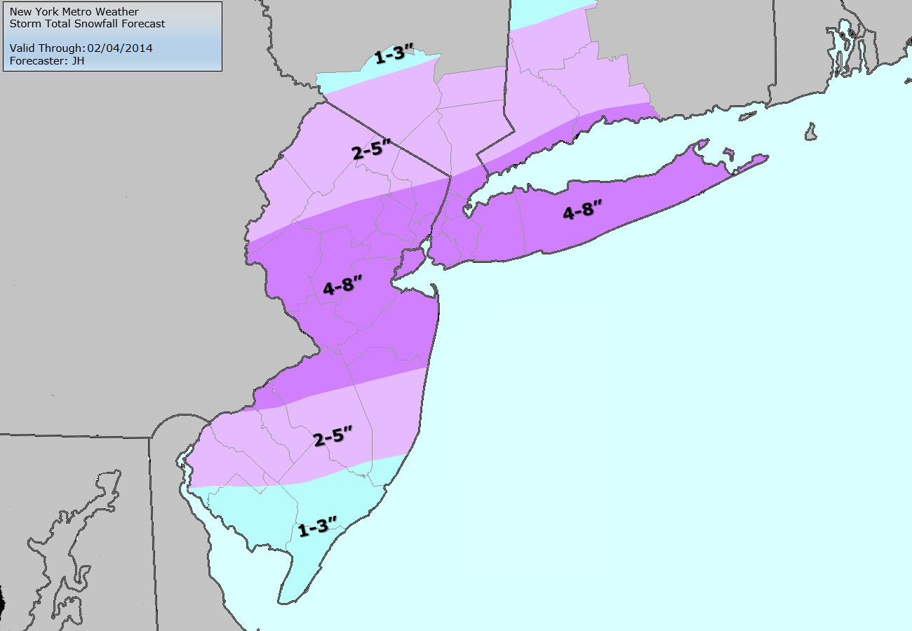
The banding is expected to continue on a southwest to northeast trajectory over the next several hours. HRRR is in good agreement with other short term models on a band of 4-8″ of snow from essentially Hunterdon County NJ through Trenton and northeastward from Monmouth Co to Staten Island NY, including Union, Somerset and Middlesex Counties in NJ. This area is prime for amounts on the higher end of that scale and the models indicate some isolated potential for amounts over 8″. Confidence in that is low and our forecast remains 4-8″ for much of that area into NYC, SW CT and LI.

Farther South in Central and Southeast NJ the transition line from rain to snow continues working south but progress has slowed. Southeast of Mount Holly, rain continues and is expected to continue over the next few hours. Some snow or sleet may mix in during heavier banding. Snow totals are expected to be lower in this area, although there will eventually be a transition to frozen precipitation later today.

Stay tuned over the next few hours and be aware of very hazardous travel. We have included our updated snowfall map below.

Read more

Moderate snowstorm likely on Monday

A low pressure system developing along a stalled frontal boundary is likely to bring precipitation to the entire area beginning early Monday morning, with cold air funneling in from the west/northwest behind the front and changing precipitation to snow throughout the area. Forecast models have trended much farther north and more expansive with the precipitation shield associated with this low pressure — and as a result, we are now expecting the potential for moderate snowfall accumulations throughout the area. There are several uncertainties still remaining with the forecast system, including timing and temperatures, but confidence continues to increase in the accumulation forecast today.

Snow is expected to begin in Northern NJ, NYC, SE NY and Connecticut during the early morning hours on Monday. Across parts of Central and Southern NJ, precipitation may begin as rain or may be mixed. As precipitation intensity increases, dynamic cooling will occur — changing most areas to snow. The exception may be in Southeast NJ and parts of Long Island, near the coast, where warmer air in the low levels will keep precipitation mixed or stop snow from accumulating. Elsewhere, moderate to heavy snow is then expected to continue throughout much of the morning and early afternoon.

Storm Total Snowfall Forecast as issued by our meteorologists on February 2, 2014.

Read more

Super Sunday warmup will be short lived

Given the nature and degree of the cold snaps so far this winter season, it seems like every warm up deserves a lot of attention. There have only been a few this year (most notably one in December and one in mid January) — and another is on the way this weekend. Conveniently timed during the Super Bowl festivities in New York City, a low pressure system will ride to the north of our area on Sunday providing a warm southerly fetch out ahead of it. The bulk of precipitation associated with the storm looks likely to stay north of our area as well, with just a few showers possible on Sunday.  There is also some potential for a period of steady rain early Sunday morning across Southern New Jersey.

Sunday will feature some of the warmest weather in weeks as high temperatures will rise through the 40’s and approach 50 during the day. A cold front will move towards the area Sunday Night — during the Super Bowl — and the wind shift will mark a change (or return) to a colder and more wintry airmass. Northwest winds will usher in much cooler air aloft and at the surface by Sunday Night, with the front moving just east of the area. But the story doesn’t end there. A developing disturbance over the Southern US will shift northeastward along this frontal boundary, potentially resulting in a winter weather event on Monday.

NAM model forecasting high temperatures well into the 40's on Sunday afternoon.

NAM model forecasting high temperatures well into the 40’s on Sunday afternoon.

Read more

Understanding the difference between potential and hype

I think I personally hit a bit of a breaking point today. Around 6:00am this morning, we received an inquiry regarding the potential winter weather events next week.  This is nothing terribly unusual — our email inbox is normally filled with these and we do our best to try and answer them and keep people informed. The title of the email read “Information Regarding Blizzard Feb 8” and the contents essentially asked us for our snowfall forecast for the upcoming “Blizzard” which the mailer was under the assumption was going to arrive next week. In the email was a model image, produced by Weatherbell Analytics, which showed the snowfall totals from a ECMWF Ensemble Control run at 200+ hours. It was then that I realized we had a big problem on our hands.

This is nobody’s fault. Not the mailer, nor the company which produced the map. It isn’t our fault, your fault, or any meteorologists. In fact — nobody is to blame. But it is a problem, because the image went viral on social media and many in the general public took it as fact. And so, as meteorologists, it is our job to source back this issue and try to figure out how to avoid it happening again. Similar things have occurred during storms in the past, as recently as a month ago, and the end result is never pretty.

This snowfall total map, which went viral yesterday, is a snowfall forecast from an ensemble member of the ECMWF model.

This snowfall total map, which went viral yesterday, is a snowfall forecast from an ensemble member of the ECMWF model.

Read more