Not done yet: Light snow likely on Friday

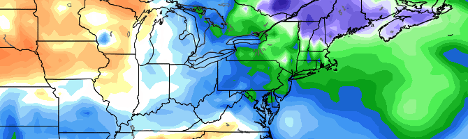
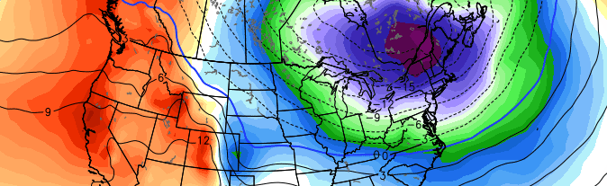
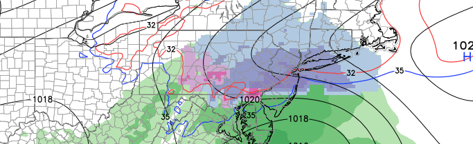
I can almost hear the collective groan of thousands throughout the New Jersey and New York City area. Yes, snow is returning to the forecast and it will bring the potential for a few inches of snow on this coming Friday. A low pressure system approaching from the Ohio Valley will move through the Mid Atlantic states on Friday, spreading moisture north of it into the Northern Mid Atlantic states. As moisture surges north into the cold sector, snow will develop within a small axis from West to East on Friday.

While the low pressure system is fairly weak, and passing well to our south, the increase in moisture and lift should be just enough to allow for snow to develop. Light snow is expected as early as Friday morning, especially over Western parts of the forecast area. With increased lift for precipitation, steady snow is expected during the day on Friday. The low pressure system will eventually shift offshore, allowing for lightening precipitation and clearing overnight Friday into Saturday.

Read more

Active, transitional pattern this week

Despite that fact that we continue to work farther and farther away from Winter with each passing day, the pattern over the next week will feature a transitional — and colder than normal — airmass on multiple days. As we mentioned last week, the presence of high latitude blocking will be the main culprit in driving cold air southward from Canada into the Northern 1/3 of the United States. Despite a changing sun angle and nearly completely melted snowpack, the potential for cold and at least some snow is anticipated to continue for the next 7 to 10 days. This week will feature a transition from a benign pattern into a more stormy one.

After  a warm and pleasant day on Monday, a frontal boundary is expected to pass the area on Tuesday with blustery winds and showers which may end as snow showers throughout the area. This will all be owing to the southward extension of a lobe of the Polar Vortex, which will be elongating and setting up shop over Southeast Canada. Very cold air — 850mb temperatures of nearly -30 C — will be bottled up just to the north of New England. And frontal boundaries will progressively seep this air southward into our area at times.

Read more

After transient warmup, winter set to return

This is not the news many were hoping to hear this morning. Unfortunately, it’s the news we have to provide as a result of medium and long term forecast modeling and the overall hemispheric evolution over the next two weeks. Luckily for those who enjoy the warmth, today looks to be the winner of the week. Behind a mid level atmospheric disturbance which provided the area with rain on Tuesday, warm mid level temperatures will remain in the area on Wednesday. Periods of sunshine and west winds will allow temperatures to rise into the mid to upper 50’s throughout the area. Some areas will approach and may even exceed 60 degrees during the afternoon. Others, especially near the shore, will remain slightly cooler.

The warmth, as is often the case this time of year, won’t last long. Colder mid and upper level temperatures will push southward on Thursday and Friday and temperatures will move back toward more normal levels. The transient pattern will continue through the weekend as another disturbance approaches — bringing precipitation mainly in the form of rain, as temperatures briefly warm up once again before crashing back down on Sunday. Still, that will be just the beginning of the trend toward a colder, more active pattern which will establish itself in the medium to long range.

Read more

On this winter, records, and cold

I enjoy data. New York City’s weather station has been keeping data records for 152 years. Yes, that’s right, observers have been collecting weather data in New York City since 1863. That, my friends, is a long time ago. Since then, there have been an innumerable amount of impressive weather events. Hurricanes, winter storms, severe weather, flooding, heat, cold. New York City’s geographic location features an incredible amount of variability and extreme differences based on location. These simple facts, as straightforward as they are, make this winter — especially from February through early March — all the more impressive.

When looking at this winter as a retrospective, although it isn’t yet over, one can easily become caught up in statistics and information. This February through March in New York City will go down in the record books as one of the more impressive and extreme winter weather periods. For both cold and snow, the past 60 days have been historic.

Read more