-2")
Organized thunderstorm potential on Monday and Tuesday
If you’re here looking for an article on the general weather over the next few days and the weekend, check out our previous article. This article will focus on the potential for thunderstorms on Monday and Tuesday, some of which could be severe.
In what could be a foreshadowing of the pattern for much of the summer, a ridge will be developing in the NE Pacific, which forces a trough to enter the Great Lakes and Southeast Canada. Wavelengths are shorter in the summer than in the winter, which means that instead of that trough being forced into our area, it generally will stay to our west. This also means and gives more room for some ridging to our south and west. The incoming troughs at times can enhance southwest flow ahead of them and thus “push” or advect some of that warm and moist air into the region in the form of a warm front. This summer, in general, should thus have periods of cool and warm weather in 2-4 day periods as warm fronts bring in occasional heat and humidity, but Great Lakes troughs will keep them from being sustained and will also bring some cool weather — very few prolonged heatwaves.
Considering we will often be on the boundary ahead of the trough and just ahead of the strongest ridging, this could mean an active severe weather season for our area. And this exact scenario could be playing out to start next week — a warm front will be pushing northward, providing wind shear, warmth, and instability, while the strong trough incoming will provide chilly mid-level temperatures, height falls, and energy for lift.
In order to keep this post short and sweet, we’ll take a look at today’s GFS model. It had previously been forecasting the warm front to stay to our south on Monday, which would mean no warmth and unstable air for thunderstorms. However, it has joined the European Model in pushing the warm front through most of the area on Monday afternoon.
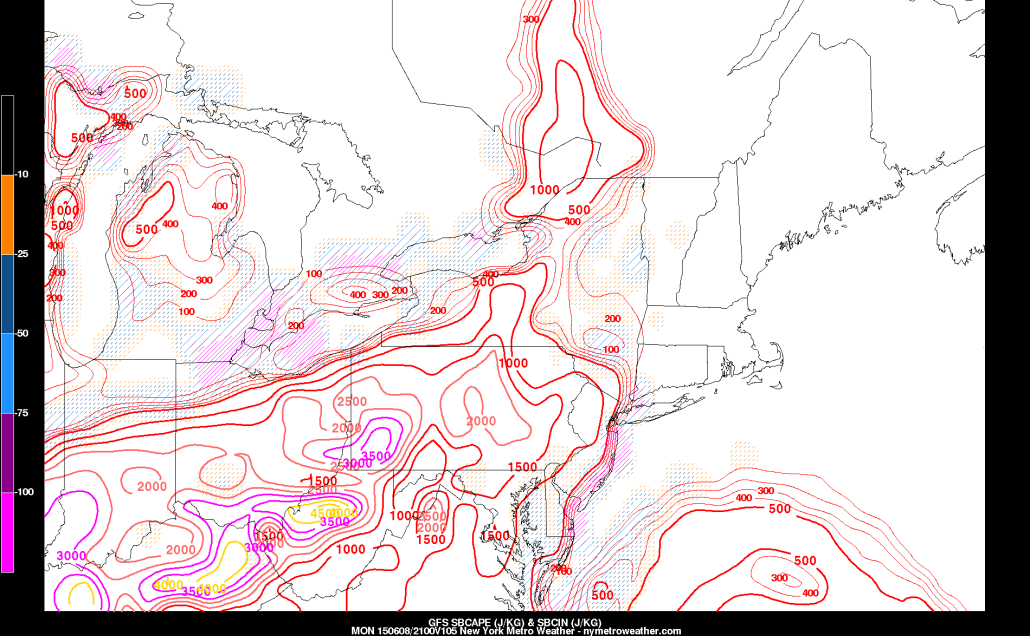
Today’s GFS model valid for Monday afternoon shows plenty of moisture, a decent amount of wind shear, and modest instability. This could lead to some strong and isolated severe thunderstorms.
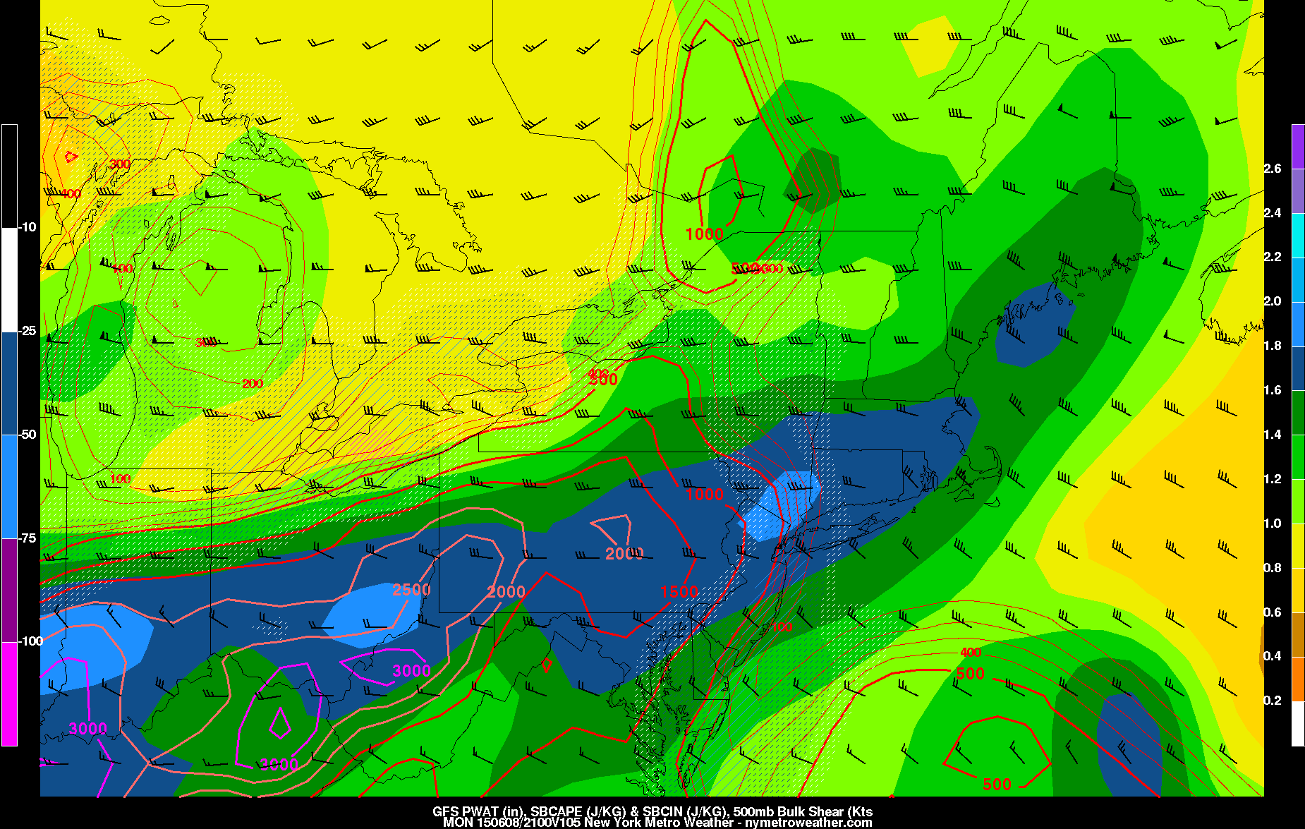
The above image shows that the GFS forecast model is forecasting very high precipitable water values — around 2″ — which means that any thunderstorm could have extremely heavy downpours and flash flooding. The warm front also pushes just far enough northeastward to push up some CAPE values in excess of 1,000 J/KG west of NYC. Some residual high pressure to the north and the marine layer may make the warm front slower to progress through the coast, keeping coastal areas — once again — out of harms way for severe weather.
The wind shear from the surface through 500mb is around 30 knots or so — which is sufficient for some thunderstorm organization, but not necessarily great for severe weather. However, the warm front will help to create very strong wind shear at the lower levels of the atmosphere — both speed and directionally — which could lead to thunderstorms with some rotation. Additionally, with the lift coming from the warm front and the trough diving in, most of the ingredients appear to be there for severe weather.
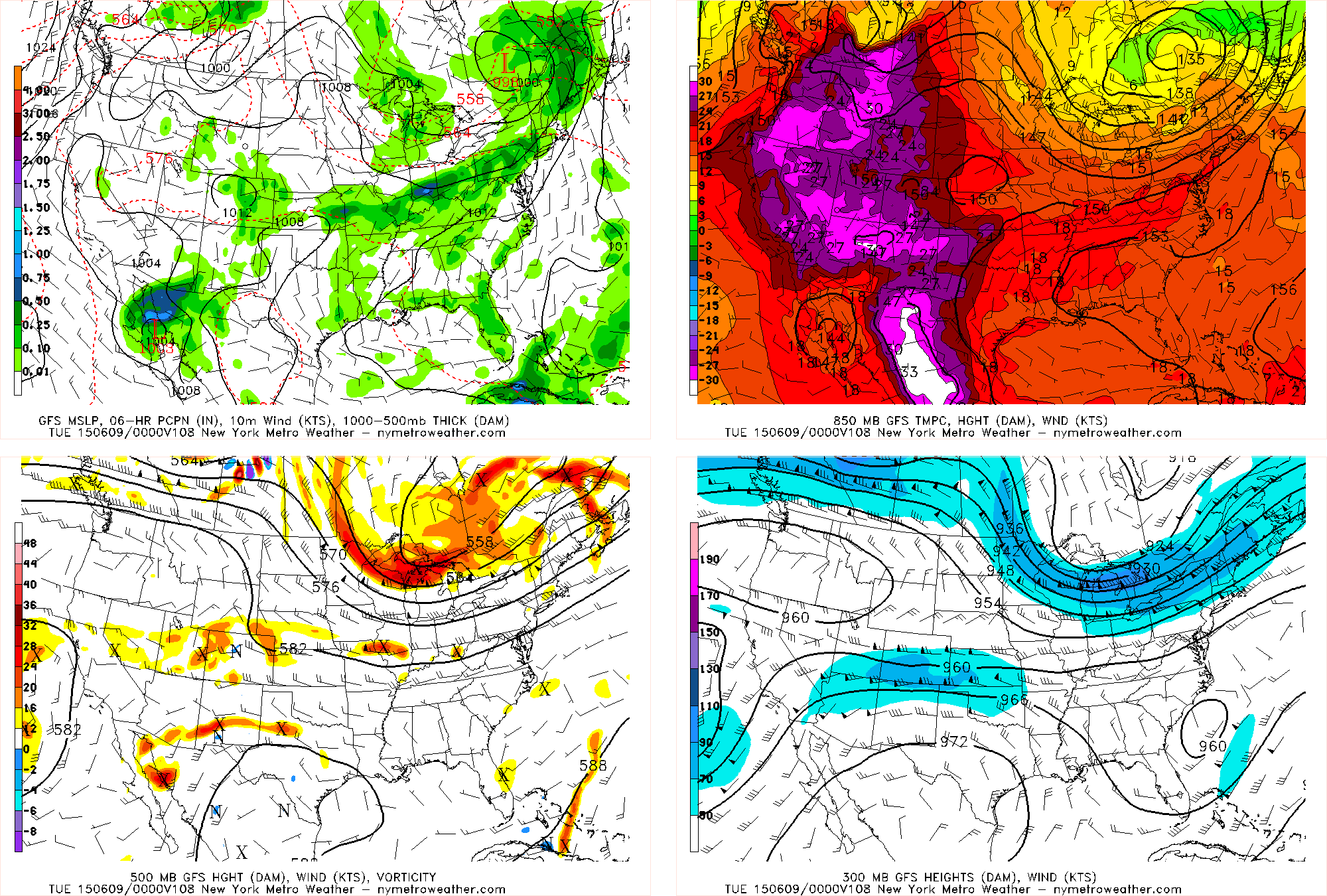
Today’s GFS valid for Monday evening shows the ridge out west and to the south, with the trough diving into the Great Lakes with plenty of energy. However, the best energy appears to be lagging well to our west.
But there are still a few potential caveats.
1) The warm front could still get hung back a bit, causing it to cross the area too late, instead simply giving us a heavy rain threat on Monday night into Tuesday.
2) There may not be enough instability to support the strong wind shear. This could mean that storms that try to form will rotate, but the winds at the low levels are too strong to support the cloud in rising, since the instability in itself may not be enough to help it rise. Ideally, you need a good balance between very high instability and strong wind shear, to support the tall, rotating, severe thunderstorms. The warm front crossing the area earlier and providing a bit more instability would keep the severe weather threat higher.
The first two points could mean that the Philadelphia area is in a better spot for severe weather than our area.
3) The best dynamics and strong mid and upper level winds appear to be lagged a bit to the west, as illustrated in the above image. The strongest vorticity and jet streak at the base of the trough is well in the Great Lakes, which means that our area may not be in the area for the best forcing to maintain severe thunderstorms. Thus, the Ohio Valley could be in a better location for severe weather than our area.
Moving forward to Tuesday, it all depends on the timing of the cold front in association with the trough. If the trough moves quickly, the cold front will blast through the area on Tuesday morning, which could hinder instability and instead create heavy rain with rumbles of thunder. If the front were to slow down, a line of thunderstorms with strong winds could be in store for Tuesday afternoon.
The rotation would not be as strong on Tuesday, due to the warm front being well-removed from the area. But if the front were to slow down a bit, then the potential for stronger forcing would be higher on Tuesday than on Monday, and thus the chance for a line of strong thunderstorms.