Incredible photos capture Typhoon Maysak from space

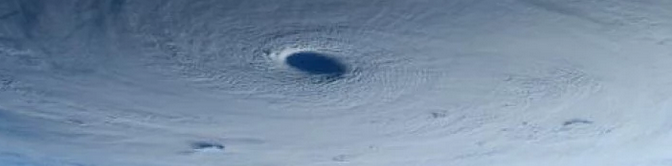
While Super Typhoon Maysak churns in the Pacific, Terry Virts and Samantha Cristoforetti sit in the International Space Station as it orbits above Earth. Yesterday, the American and Italian astronauts sent back some incredible images of the Typhoon and its structure. With winds sustained at 160 miles per hour on Wednesday, the Typhoon was one of the strongest to develop so early in the Western Pacific Ocean. The structure and size of the storm become incredibly impressive in the images they’ve posted.

High resolution cameras have allowed astronauts on the International Space Station to provide us with incredible images over the past few years. The astronauts aboard frequently post night and daytime images of major cities and world geography as seen from the low-orbit space craft. In the images of Maysak, the storms structure becomes apparent. An impressively organized eye and organized cloud tops make it easy to understand the power of the storm below. High resolution cameras even allow to you to see the vorticies within the eye itself.

All images below captured by Terry Virts and Samantha Cristoforetti aboard the ISS. Click here for more information on Typhoon Maysak.

Read more

Brief warmup ahead of late week cold front

After a cold start to the week, with snowflakes flying in New York City and light accumulations across the interior and higher elevations, temperatures will finally rebound during the middle to latter part of this upcoming week. High temperatures on Wednesday will reach into the 50’s, which will feel especially warm after the aforementioned early week weather. As a mid level ridge builds over the Northeast US from Wednesday Night into Thursday, temperatures will be given an additional boost — and may reach over 60 F for highs on Thursday afternoon.

Southerly winds will be the main culprit in bringing the warm air into our area, and so the usual concern will arise: Temperatures won’t be nearly as warm near the coast and on Long Island as they will be from New York City Westward. Yet, the air will be more moist and humid — so it will certainly feel like Spring regardless of where you are.

Read more

Could it actually snow on Saturday?

You can’t really be surprised that snow is once again in the forecast, can you? After a two month period featuring record breaking cold and snow, temperatures soared into the 60’s on Thursday evening. But a cold front swept through the area Thursday Night, ushering in colder than normal air once again. Highs on Friday barely reached into the 40’s. And on Friday Night into Saturday, forecast models are indicating a return of post-frontal precipitation with a chance of, yes, light snow throughout the area and into New England.

As a large mid and upper level system slides from the Ohio Valley to the Northeast US Coast, enough atmospheric energy will force the development of a low pressure system offshore. While the center of low pressure will be hundreds of miles to our east, an inverted trough extending westward from it will be the culprit in our snow chances. Light snow could develop as early as Friday Night and is expected to continue in parts of the area until Sunday morning. But the location and intensity of the snow becomes the main detail we’ll have to iron out.

Read more

Spring Weather: Severe thunderstorms, and the SPC

Each year, as the atmospheric pattern begins to undergo a transition and wavelengths begin to change, the threat for strong to severe thunderstorms becomes a focus of the meteorological community in New Jersey, New York and Connecticut. Spring, in fact, marks the beginning of “Severe Weather” season in our area — which generally has been known to begin on May 1st. There have obviously been severe thunderstorms before May 1st, but in general the most consistent potential for organized severe storms begins in May and ends in August or September.

Interestingly enough, severe thunderstorms feature some terminology and atmospheric interactions which can be very confusing not only to interpret as meteorologists, but to understand on the public level. Knowing the basics of how organized thunderstorm events develop, and how forecasters attempt to predict and quantify their potential, will help to make things a little less confusing when severe weather season comes around this year.

Read more