-2")
Arctic air, storminess, and pattern longevity
Lets face it — there has been a ton of conversation in regards to this colder pattern over the past few weeks. Our team of forecasters has been talking about it for more than a few weeks now –and it is finally arriving this week. A piece of the polar vortex (yes, the one you hear about a lot) will drop southward into Canada and eventually through parts of the Northeast states late this week. This will lead to temperatures dropping well below normal over a large part of the region.
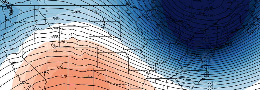
In fact, temperatures may fall 20 to 30 degrees below average over a vast majority of the Northeast from Thursday through Friday, as the heart of the cold swings overhead. See, the cold is being very notably displaced from the arctic and North Pole. We spoke last week about the importance of a ridge of high pressure building north of Alaska. This has disrupted the flow of air near the pole, pushing cold air far south — and towards the Great Lakes and Northeast states.
An active storm track is expected to continue, with disturbances still crashing into the Western US and pushing eastward. But there is more to this than just activity — the progressive nature of the jet stream and lack of blocking means the arctic air won’t stay around very long. “Blocking” refers to unusual ridges of high pressure or ridges in the atmosphere that act to slow down the wave pattern in the atmosphere. Often times, without these blocks, the pattern continues to move along at a very quick pace. This time will be no different — the polar vortex will be lifting our of the Northeast US by the time the next system arrives.
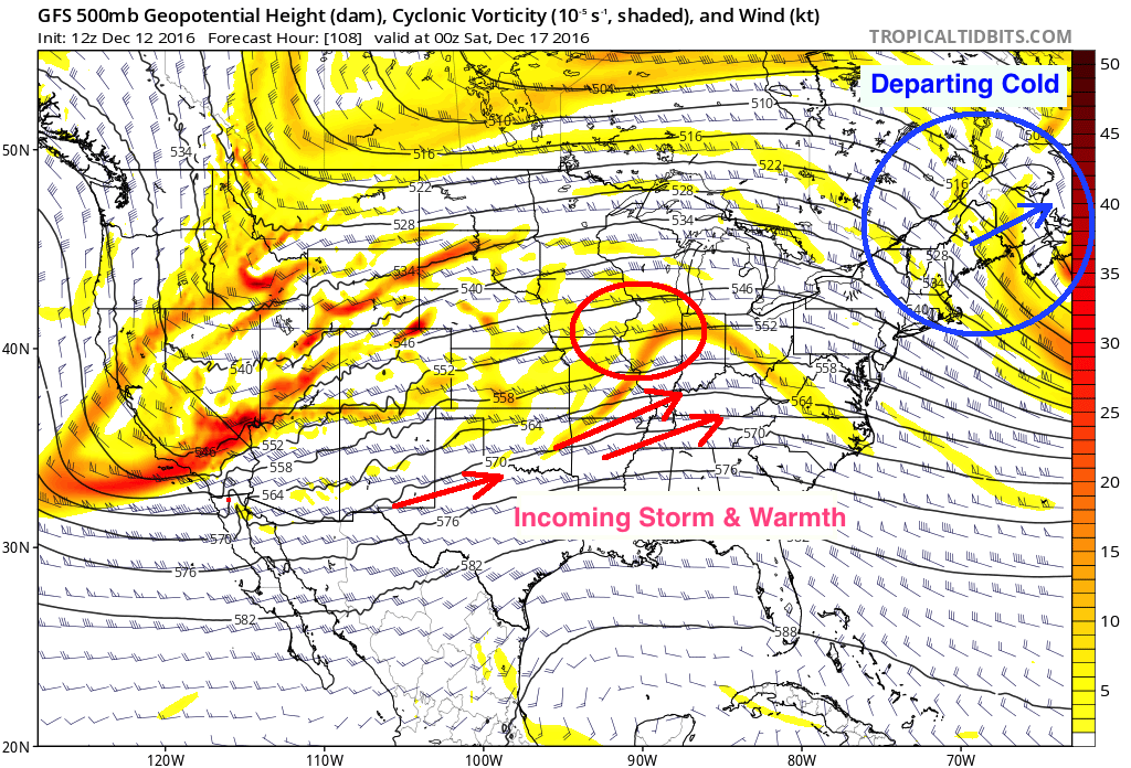
A breakdown of the atmospheric setup shows us what is happening and why. We are looking at 500mb heights (black lines) and energy (colored area). These charts show us the height/wave pattern in the atmosphere and the area where disturbances and energy are tracking. We can see the departing cold air on the far top-right of the screen. But more notably, we can also see the weekend storm system approaching. The system is being driven towards the Northeast by a warm, southwest wind — and it is bringing the warm air with it. This almost ensures that a main characteristic of the system will be warm air – even if precipitation starts as snow.
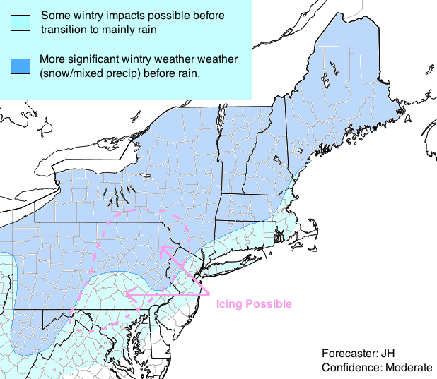
It is not surprising, then, to see models suggesting a changeover to rain throughout a large majority of the region despite the very cold air that had arrived just 24-48 hours earlier. Breaking down the exact depth of the cold air will be critical to the forecast, especially over the interior. Despite this warm air surge, interior areas and New England particularly could still see several hours of wintry precipitation, leading to fairly notable impacts on Saturday. We have included basic overview areas
Beyond the weekend storm system, the pattern looks to undergo significant changes. The same areas which helped to bring cold air south towards the Northeast will regress nearly to the opposite of that — now with more troughing in those areas. What does this mean? Basically, without a propelling force to disrupt cold air from its typical location, it will tend to stay bottled up near the poles and in the arctic. A trough developing over Alaska and into the Northeast Pacific Ocean (also known as a positive Eastern Pacific Oscillation) will often lead to the development of a Southeast Ridge.
This is exactly what is being signaled on ensemble guidance through the end of December. Cold air looks likely to retreat, and as the polar vortex restrengthens in its usual location, the Southeast Ridge will flex its muscles here along the East Coast. This will allow temperatures to moderate as we approach Christmas Week, with an end to below normal temperatures and a return to above average temperatures. While the active storm track looks to continue, warmer temperatures look likely to become established as we head towards the end of the month overall.
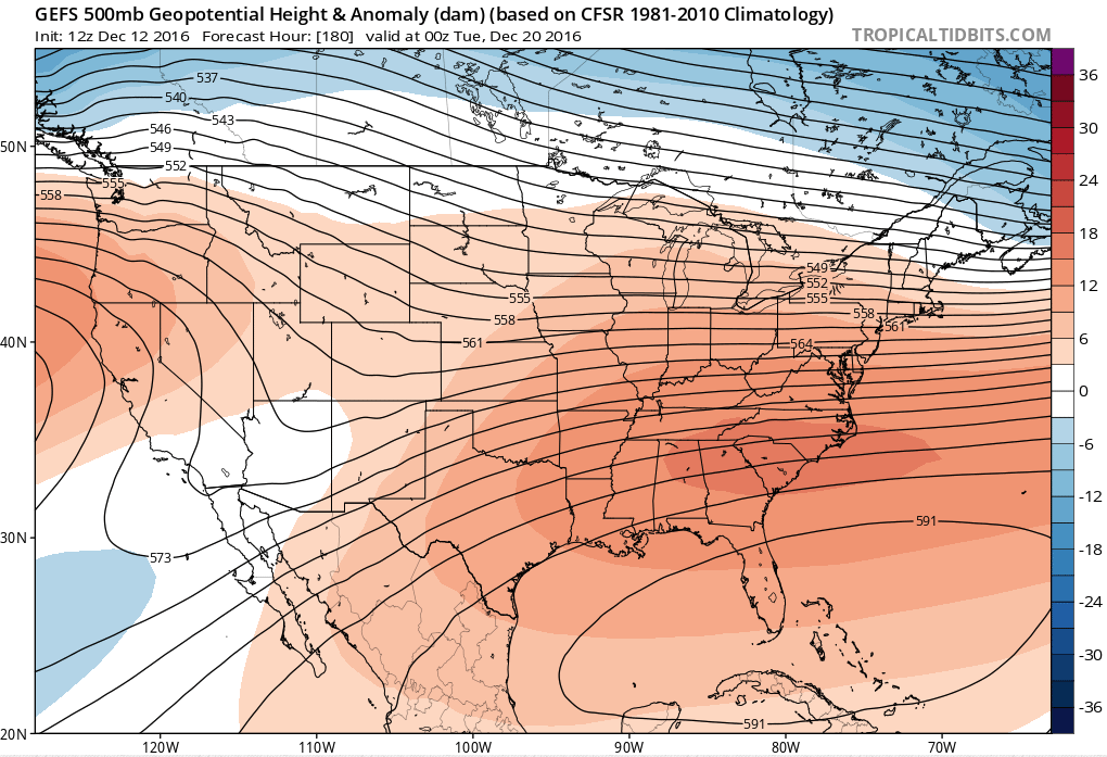
GEFS model showing a southeast ridge developing and strengthening by the end of December
That’s all from us until next week — we hope you’ve enjoyed the read! To gain access to Premium Posts such as this one (daily), plus videos, interactives, discussions, maps, and more, CONTACT US TODAY and become a client at New York Metro Weather LLC. Our team of forecasters works hard 24/7 to tailor forecasts and discussions to individuals and businesses to take the guessing game out of forecasting and bring explanations that help you understand what is happening and why. We hope to hear from you soon!
Trackbacks & Pingbacks
1broaden
Comments are closed.