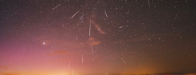
Perseid outburst expected to make 2016’s shower special

The Perseid meteor shower is always a highlight of the astronomical year, frequently bringing one of the most consistent meteor showers to the night sky in late summer. The warm weather and often favorable moon phases mean the Perseid’s are also one of the most comfortable meteor showers to enjoy. 2016 is expected to be even better than usual: An outburst of meteors is forecasted, resulting in nearly double the typical rate of meteors per hour during the showers peak from August 11th to 12th.

The meteor shower occurs each year as Earth passes through the debris tail of Comet Swift-Tuttle, resulting in meteors for several days with a peak of 1-2 days typically in mid-August. Comet Swift-Tuttle is the largest known object to repeatedly pass by Earth, with a nucleus about 16 miles wide. It last passed by in 1992, and won’t pass again until 2126. Our respective orbits, however, mean that Earth passes through the debris trail of the comet every year.

Read more

Sunday Overview: Tropical rains, flooding likely again

Tropical moisture and just enough lift combined to support the development of torrential rains on Saturday, with localized flash flooding reported both in New Jersey and throughout the Mid Atlantic. Much of the same is forecast on Sunday, with a warm front nearing the area during the afternoon. This may be particularly true across Northeastern New Jersey, where a convergence zone will allow for moisture to “pool” along a frontal zone.

This allows for a few things to occur, but most notably, it juxtaposes lift and moisture to develop torrential rains. With plenty of anomalous moisture still available throughout the area, the recipe could be there once again for flash flooding in localized areas. Upwards of 2″ of rainfall in relatively short periods of time could cause problems, especially in flood prone areas.

Read more

Analysis: Heavy rain, storm potential Friday morning

A mid level atmospheric disturbance will approach the area from the southwest later Thursday Night into Friday morning, bringing with it plenty of tropical moisture and lift. As the disturbance shifts toward the Mid Atlantic states and eventually off the coast, a surface low pressure area will develop in the same adjacent areas. This will enhance lift in the atmosphere — allowing heavy rain to develop just to the north of the low pressure area.

Within an airmass characterized by precipitable water values over 2.50″, this lift will support the development of heavy, torrential rains from Thursday Night into Friday. Movement from southwest to northeast of heavy rain, and embedded thunderstorms, is anticipated. Exactly where the heaviest bands fall will depend on a few things; namely convection, and placement of the best mid level lift and vertical velocity.

Read more

Unsettled Weather with Heavy Rainfall Possible on Friday

A prolonged heat wave, which has brought temperatures in the upper 90’s and near 100 over the past several days, will continue through Thursday. But changing weather is on the way thereafter, beginning as early as Thursday Night. A storm system approaching from the southwest will bring more unsettled weather, and the potential for heavy rain. There is some uncertainly with the exact impacts from the system over the region, but the potential exists for heavy rainfall which may cause flooding and local travel impacts on Friday morning.

A shortwave trough will be moving into the region from the Ohio Valley late in the day on Thursday. This will cause an area of low pressure to develop near the Virginia Coast then track northeastward by Thursday night and Friday. Some widely scattered showers and thunderstorms may start developing over parts of the region, well ahead of this system, later Thursday afternoon and early evening. There might enough lift and instability for strong thunderstorms with a surface trough or sea-breeze boundary pushing inland over the region.

Read more