Monday Overview: Pleasant weather today…warming trend for the week

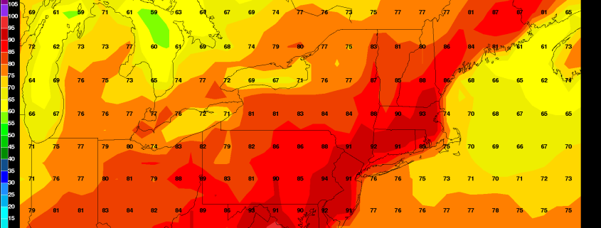
This past weekend was kind of dreary overall with more clouds and showers around. But early this week, is look more beautiful. Some clouds may mix with sunshine at times today. But more sunshine is anticipated today with high pressure over the region. Temperatures will rise into lower 80s over much of region this afternoon with light northerly winds. These temperature are few degrees below average. But it will still feel pleasant overall with low humidity.

This pleasant weather will continue into tonight, with any clouds during the evening hours clearing overnight. Temperatures dropping into the middle to upper 60s over much of the region. Overall this week’s weather looks benign, until Thursday and Friday when some heat and thunderstorms likely return to region. Here are some highlights for this week:

Read more

Saturday Overview: Cooler Today with More Showers/T-storms Possible Later

For those who were sick of the heat, today will be a gift: A cooler, less humid day. You can thank a backdoor cold front that has pushed into Delaware River Valley this morning. Mostly cloudy skies and onshore winds are anticipated for much of the area for the remainder of the day. This will keep temperatures from rising out out of the lower to middle 70s. Low pressure tracking north of region will try to push this front back east as a warm front this afternoon. This could cause skies to clear for sunshine and temperatures to rise into the 80sover Western and Central parts of New Jersey, later this afternoon. However a secondary low will developing south of region this evening, will likely keep this frontal boundary moving through the rest of region today.

Some scattered showers and thunderstorms are possible, with this frontal boundary, mainly during the late afternoon and evening hours. SPC has issued marginal and slight risks for western parts of region today. Stronger shear with an associated upper-level trough, will support more organized convection to develop over Eastern Pennsylvania . However, instability will be lacking over much of the region today. The best chance for strong or severe thunderstorms, is over Western or Central parts of New Jersey. This is where surface-based instability could increase with some clearing possible later this afternoon. While a more stable marine layer, will more likely cause thunderstorms to weaken as they move further east over rest of region. Some heavy rainfall and lightning is still possible. Some other highlights for this weekend:

Read more

Friday Overview: Heat, humidity, more thunderstorms expected

The heat and humidity is back this morning, and it’s expected to stick around through the day. Temperatures will rise from the 70’s this morning into the 90’s once again early this afternoon. The combination of the heat and humidity will push heat index values into the middle 90’s once again throughout the area, despite temperatures remaining a bit cooler (as usual) near the shore.

The main story today will be the development of a seabreeze front, which is part of a larger “backdoor” cold front pushing toward our area from the Northeast. This boundary will serve as a convergence point for moisture, heat, and humidity — as well as atmospheric instability and lift for thunderstorms. An approaching disturbance in the atmosphere is likely to aid in storm development this afternoon and evening, some of which could be strong — especially over New Jersey. Some other highlights through the weekend:

Read more

Thursday Overview: Hot and humid, a few strong storms

Hot and humid weather will continue today, with heat index values expected to again rise into the mid to upper 90’s by the late morning and afternoon hours. The temperatures will again be hot, but the bigger story by this afternoon and evening will be the dew points, which are expected to rise into the 70’s. The combination will lead to heat index values higher than yesterday. The air will feel quite oppressive as well, especially as the afternoon draws on into the evening.

Read more