-2")
Increasing potential for significant snow next week
Four months have gone by since we first began tracking the potential for snow and cold in November. The best atmospheric weather pattern for significant snow chose not to arrive until the middle part of March. Yet, here we are, tracking the potential for a tremendous storm system to impact the Northeast United States early next week. Forecast models have begun to hone in on the development of a strong low pressure system off the coast, with tons of moisture and cold air available.
A few weeks ago, our forecasters were tipped off to this potential by the development of high latitude blocking. This is a critical component to any forecast, especially for cold and snow, and especially in the Northeast United States. See, these high latitude blocks are extremely disruptive to the atmospheric flow. Essentially, ridges of high pressure develop way up in the polar and arctic regions and “Block” the progression of systems through the region. They also dislodge cold air, which normally would be bottled up in the higher latitudes, further south into Canada and sometimes New England.
The combination of this blocking and an active number of disturbances entering the United States often means trouble. The pattern over the next several days will be no different. After one snowstorm this morning in the Northeast, a second disturbance will approach this weekend and miss harmlessly to our south and east. But looming to the northwest are two strong disturbances, dropping south into the Plains and Central US, looking to interact and possibly phase and form a larger and more powerful storm early next week.
Okay — what the heck is going on, and why?
The atmospheric setup which is aiding in the development of the storm system next week is extremely impressive, and equally complex. We know that there is high latitude blocking in place, forcing cold air further south over Canada. But in addition, we have a large ridge developing on the West Coast of the United States. This means that any disturbances coming over the top of this ridge will dive southeastwards on the periphery of it, into the Central United States, and amplify.
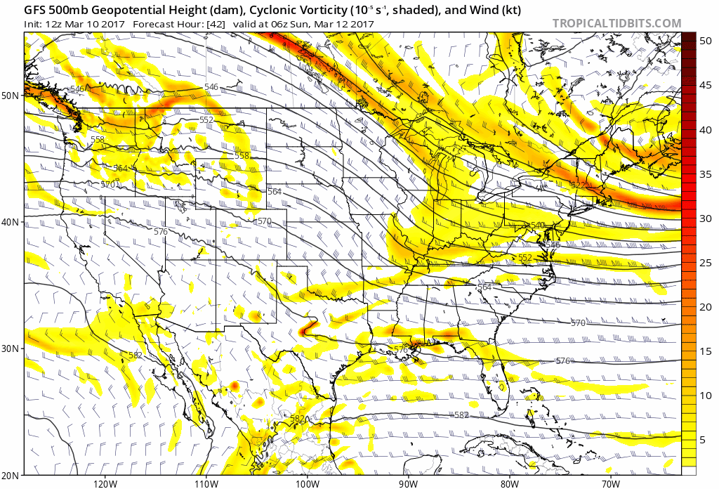
GFS model showing the evolution with two disturbances phasing and producing a large powerful storm in the East.
While one disturbance dives south into the Central United States, another arctic disturbance will move south through the Great Lakes — as a result of the blocking we discussed before. As the two interact, the trough over the Eastern United States will depend. The disturbances interaction will cause the development of a very strong low pressure system off the Eastern US Coast, moving from a position off the Outer Banks of the Carolinas up the East Coast. But exactly how it gets there will be the critical component to the forecast.
What are the complexities with the forecast?
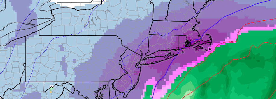
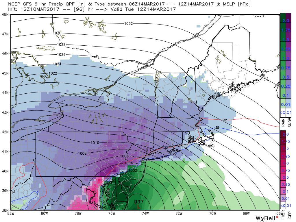
Some forecast models suggest an aggressive phase and interaction between the two disturbances we mentioned. This would cause the low pressure system to develop further west, stronger, and more impactful. Very heavy precipitation would move up the entire east coast from Monday Night into Tuesday, with a strong low pressure system developing offshore and impressive atmospheric dynamics at play. A significant snowfall event would be likely throughout the Northeast, with precipitation likely changing to rain along the coasts and possibly evening the big cities along I-95 (but not before significant snowfall).
A less phased solution, which appears on many forecast models today, could take the storm system from the Outer Banks to a position just southeast of Long Island. This would be the most impactful track, with widespread significant snowfall along the I-95 corridor and surrounding areas of the Northeast US, including the coast and even parts of the interior. Finally, a further southeast track is still possible as well — but remains an outlier solution — and would cause the heaviest precipitation to remain near the coast.
GFS model showing a large, highly impactful storm system — but a track slightly further west bringing rain into parts of NJ.
The uncertainties all stem from the interactions between the two disturbances which we have discussed. Exactly how they interact with each other will determine where the low pressure tracks, how strong it is, and where the heaviest precipitation/snowfall occurs. Over the coming days we will watch carefully and begin to pinpoint exactly where these locations will be.
Okay, enough of this. What do we know right now and why is this a big deal?
What we know right now is different from what we usually know, and that’s what makes it significant: The overall atmospheric pattern ahead of this storm is very favorable for a significant snow event. This is not your typical setup, at all, and due to the high latitude blocking in place the percentage chance of a significant event occurring is much higher than usual.
It’s also important to understand that ensemble agreement is extremely impressive for this range and time frame. Ensembles are essentially “Satellite” models which are run underneath major global weather models. The ensembles are run 30, sometimes 50 times, and each one produces a different solution. Meteorologists take the mean of the ensembles to help smooth out some variance, and also look at outliers to help understand the forecast envelope. In this situation, the tremendous majority of ensemble data is suggesting a widespread, significant snowfall event for the Northeast US. It is important to consider the significance of that as we move forward.
So! Stay tuned over the next day or two as we continue to take in more information. Our team of forecasters is working hard to put together all of the data and use our knowledge of the atmosphere to put out the best forecast and do the best job at explaining it. For detailed information on a very specific basis, with posts like this multiple times per day, sign up for Zone Forecasts today.
Trackbacks & Pingbacks
1gainsay
Comments are closed.