-2")
Blizzard likely Tuesday with widespread significant snowfall
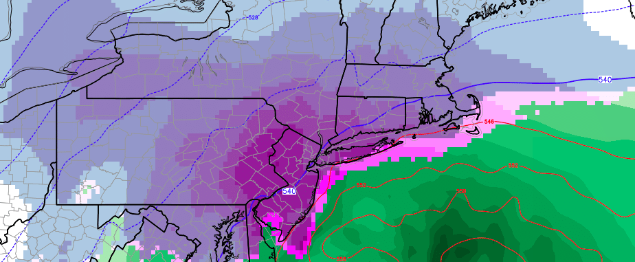
A powerful Nor’Easter is expected to develop off the coast of Mid Atlantic late Monday Night, strengthening and moving to a position southeast of Long Island on Tuesday. Bands of extremely heavy snowfall are expected to rotate inland from the strong storm system, impacting a large majority of the Northeast United States from Washington, DC to Boston — and most areas in between. Snowfall amounts are expected to be significant over a large area.
The storm system is developing as a result of a complex interaction in the mid and upper levels of the atmosphere, and some uncertainty still exists in regards to the exact track of the storm system. However, confidence is higher than normal that the storm system itself will bring significant impacts. We suggest planning ahead and adjusting your schedule as necessary to accommodate for significantly impactful weather on Tuesday. We’ve laid out a breakdown of the storm system below.
Why and how is the storm system developing in the first place?
A few weeks ago, our forecasters were tipped off to the potential for significant snow by the development of high latitude blocking. High latitude blocking is a critical component to any forecast, especially for cold and snow, and especially in the Northeast United States. See, these high latitude blocks are extremely disruptive to the atmospheric flow. Essentially, ridges of high pressure develop way up in the polar and arctic regions and “Block” the progression of systems through the region. They also dislodge cold air, which normally would be bottled up in the higher latitudes, further south into Canada and sometimes New England.
The combination of this blocking and an active number of disturbances entering the United States often means trouble. The pattern over the next few days, as it turns out, will be no different. We know that there is high latitude blocking in place, forcing cold air further south over Canada. But in addition, we have a large ridge developing on the West Coast of the United States. This means that any disturbances coming over the top of this ridge will dive southeastwards on the periphery of it, into the Central United States, and amplify.
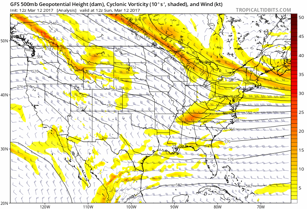
GFS model showing the interaction of two disturbances in the upper levels of the atmosphere from Sunday through Tuesday.
While one disturbance dives south into the Mississippi River Valley, another arctic disturbance will move south through the Great Lakes — as a result of the blocking we discussed before. As the two interact, the trough over the Eastern United States will deepen. The disturbances interaction will cause the development of a very strong low pressure system off the Eastern US Coast, moving from a position off the Outer Banks of the Carolinas towards New England. As this occurs, the system will rapidly strengthen and spread precipitation into the I-95 corridor and surrounding areas.
What are some uncertainties that still exist?
It’s no secret at this point that confidence in the development of this storm system has been higher than normal. Forecast models have provided hints of its development up to two weeks in advance and, by and large, the signal for a significant snowstorm has remained stout for the last 5 days in a row. However, there are still intricate interactions occurring that will be able to tip the forecast in either direction as the storm occurs.
The main uncertainty continues to be the phasing and interaction between the two shortwaves above. Exactly how this occurs will likely determine where the storm tracks, how strong it is, and where the heaviest snow bands set up. Looking into some more intricate details, the banding (which develops as a result of the interactions we mentioned above) will determine who gets the prolific snowfall totals.
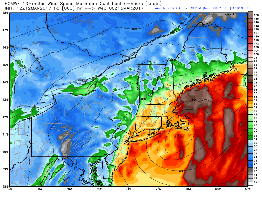
European model showing very strong wind gusts near the coast as the storm passes by.
As the storm system strengthens rapidly, a process known as frontogenesis and deformation banding occurs. As temperature gradients tighten in multiple levels of the atmosphere, lift and upward motion is enhanced in the atmosphere. This allows very heavy precipitation to develop — and incredible snowfall rates occur as a result. Forecast models have suggested these extremely heavy snow bands will traverse through the region Tuesday. Pinpointing their location will be critical over the next 24 hours.
What are you forecasting and what are the recommended preparations?
The best idea, by far, is to prepare for a blizzard with significant impacts. The large majority of the region is expected to experience a severe winter storm. We expect widespread travel impacts — and suggest adjusting your schedule accordingly. School cancellations should be numerous. Travel will be extremely difficult if not impossible from late Monday night through Tuesday.
Winds will be significantly impactful. As the storm passes close to the region, there will be the potential for wind gusts over 50 miles per hour. Damage to property and power outages are not out of the question, and you should have a plan in place in case that does occur.
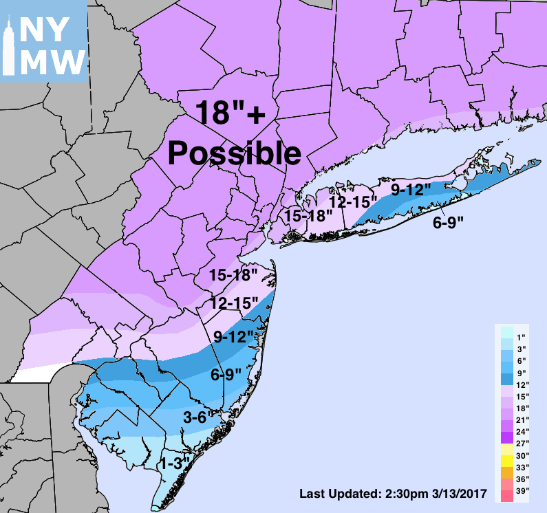
Our first official storm total snowfall forecast is included above. Please note that the main purpose of this map is to delineate the areas which we anticipate will see the heaviest snowfall banding and highest impacts. The map may shift or change over the next 24 hours as new data is available and observations are taken into account.
Stay tuned for further updates and, as always, be sure to contact us with any questions. For more detailed videos, frequent updates, and commercial-based services such as hourly forecasts and snowfall verification, sign up for Premium Products today.