-2")
Significant storm system to impact Northeast states
A well discussed storm system is in the process of developing this Saturday evening and overnight, as a large and anomalous trough digs into the Mississippi River Valley. Meanwhile, Tropical Storm Phillippe continues to move swiftly through the Caribbean, shifting northeastward and eventually on track to interact with the aforementioned trough. While the two disturbances will not completely “phase”, they will interact – and the result will be the development of a powerful storm system by late Sunday.
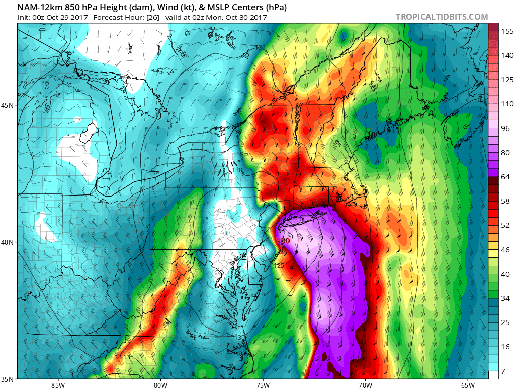
Forecast models are in good agreement that a deep and impressive trough will swing through the Eastern States on Sunday, with tropical moisture rapidly advecting northward near a thermal gradient. As lift increases near the very impressive trough, heavy rain will surge northward along the East Coast. A strong low pressure system will develop rapidly near the Delmarva, eventually tucking inland near New Jersey and Pennsylvania.
Powerful atmospheric dynamics are expected to develop through the Mid Atlantic states and then through New England, namely a strong low level jet with winds in excess of 70 knots. This low level jet stream will surge northward, reaching Long Island and New England by late Sunday evening and bringing with it increased moisture and torrential rains as well as powerful and potentially damaging wind gusts. Strong mid-level vorticity swinging through and a dual jet streak associated with an upper-level trough over the East coast will also enhance heavy rainfall and rapid deepening of this storm system.
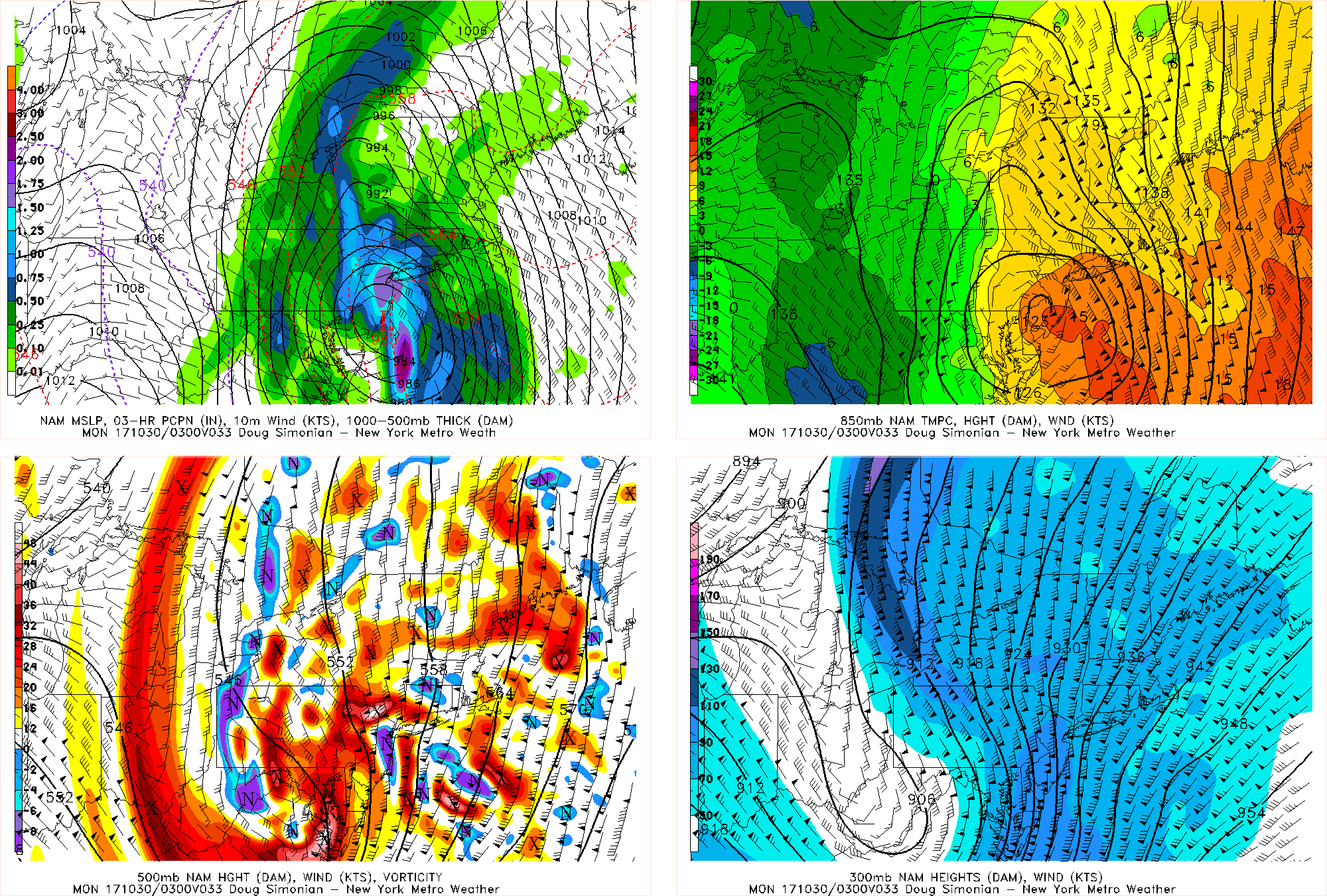
NAM model showing 500mb vorticity and 300 dual jet streak, enhancing a deepening of low pressure and more areas of heavy rainfall over the Northeast, Sunday night
Thus, the National Weather Service has issued various flood watches, high wind watches, and warnings for parts of the Northeast. Rainfall totals between 2″-4″, with locally higher amounts, and wind gusts over 50 mph are becoming increasingly likely. A period of very strong winds are likely parts over Long Island, Coastal CT and other parts of coastal New England, as a 90 knot southeasterly 925mb jet moves through late Sunday afternoon into Sunday night. This will also provide plenty of moisture, lift, and dynamics for rain that will be very heavy and even torrential at times, along with a few isolated rumbles of thunder. Heavy rain could help mix the stronger winds the from jet down to the surface, resulting in a few gusts possibly near hurricane force for these areas. These winds will result in higher surf and some beach erosion along the shores, with wave heights between 10-15 feet. Fortunately, tides are astronomically low, between a full and new moon; but minor to moderate coastal flooding is still possible in some spots.
We also have to watch for more westward shifts with the low pressure track that would result in wind gusts near or over 50 mph for New York City and Northeast New Jersey, and over 60 mph for Long Island. Further inland, winds will likely be weaker, as they will be closer to the low track. The strongest winds will surround the storm on its west and east sides — though certainly be stronger on its east side — rather than closer to its center.
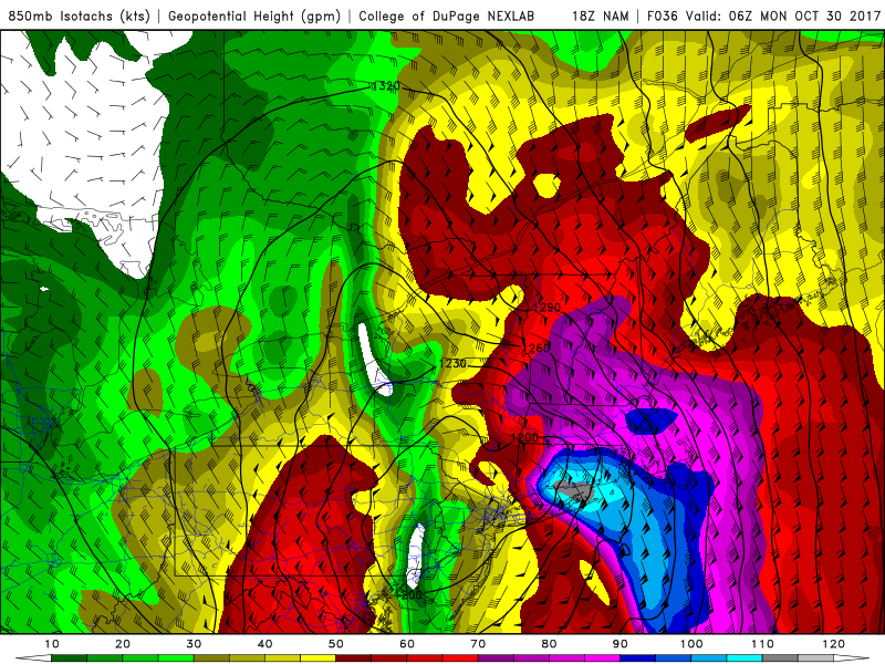
NAM model showing a low-level jet streak with winds over 100 knots at 850mb over Eastern LI and SE CT Sunday night (NEXLAB).
The core of the low-level jet will be somewhat displaced to the east of the storm, where the strongest pressure gradient combines with the very little friction over the Ocean. This jet in particular will be further enhanced because the storm’s warm sector is inherently stronger because of the tropical influence from Philippe that will be advected through the warm Gulf Stream. This further increases the instability and the temperature gradient which help fuel the jet in the first place. Additionally, the storm itself will be undergoing rapid intensification as it’s absorbing this tropical moisture, potentially dropping near 970mb. This further helps to circulate the strong, tropically moist warm sector into the cooler air on the storm’s west side. This is why we are seeing such a ridiculously strong low-level jet being modeled. While the atmosphere will not be incredibly unstable, the extreme moisture and wind shear as well as no stout inversions may be just enough to help bring down some of the incredible low-level jet winds down to the surface in the form of wind gusts. This is why we are so concerned about the potential for wind damage on Long Island.
The European Model shows extremely high wind gusts in excess of 70 mph for all of Long Island, because the low pressure tracks far enough west so that the core of the low-level jet encompasses the whole island. Were the storm to track further east, this low-level jet would also shift further east, sparing most of the region of any damaging winds. The gradient between between the core of the low-level jet and the much more stable center of the storm will be very sharp, so figuring out where exactly this low-level jet tracks will be crucial. It’s conceivable that a 30-mile difference from west to east could mean a maximum wind gust change from 40 mph to 70 mph.
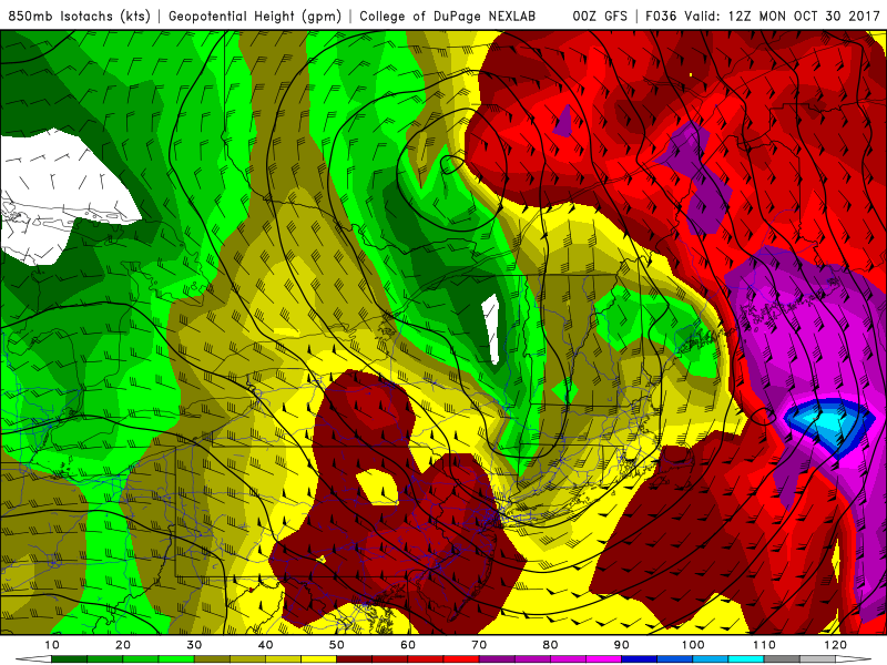
The GFS model showing a 50-60 knot 850mb jet on Monday morning (NEXLAB).
After a lull in the wind during the latter half of the overnight, another period of strong, gusty winds is likely with west-northwest winds behind the storm on Monday morning, as the storm continues to deepen and consolidate while tracking inland into Upstate New York. A tightening pressure gradient will cause an 850mb jet around 50-60 knots to move through on early Monday morning. While this is a weaker jet than the one coming through on Sunday evening, the atmosphere will be more unstable, causing much of these winds at this level to mix down to surface. There some indications from model soundings that a MAUL (Moist Absolutely Unstable Layer) may be present, which is a classic ingredient to transport very strong wind gusts down to the surface. This means Monday morning’s wind gusts will likely be stronger for inland areas than on Sunday night, perhaps exceeding 50 mph.
As far as the rain is concerned, the low-level jet bringing dynamics and plenty of moisture combined with the tropical influence and dual upper level jet will provide plenty of lift for heavy rain. A mini low-level jet will help generate a narrow band of light to moderate rain during the overnight, which could bring anywhere from 0.1″ to 0.5″ of rain to where it hits, though with it being narrow, it may primarily be for Long Island. After perhaps a brief lull, multiple bands of heavy rain will arrive from due south to north on late Sunday morning and early Sunday afternoon, as the stronger low-level jet gets going. Then the heaviest rain will arrive late Sunday afternoon into Sunday evening, with potentially torrential downpours.
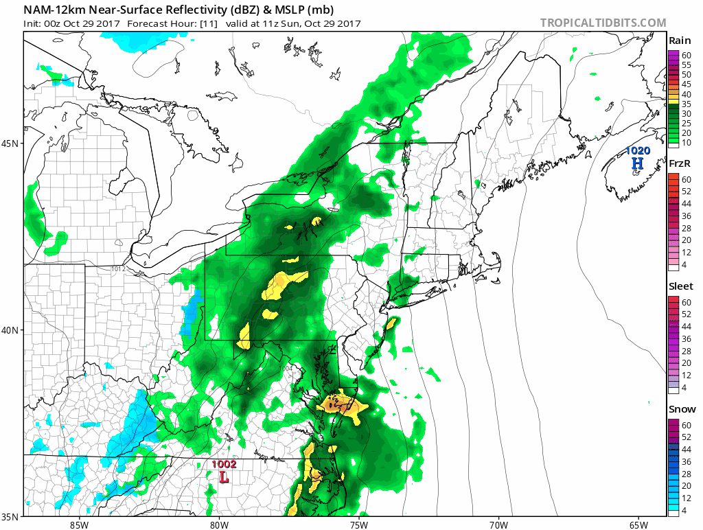
The NAM model showing multiple areas of convergence, with subsidence in between, and thus varying rainfall totals across the area on Sunday afternoon.
It’s difficult to get extremely precise with rainfall bulls eyes and minimums, but we can somewhat attempt this based on the above map. One element we look at for lift and precipitation is surface convergence. Convergence that generates lift can happen in two ways: 1) air parcels colliding in differing directions, forcing an upward lift, somewhat like how tectonic plates force a volcano to rise, and 2) very fast air parcels rapidly decelerating. The bottom left panel shows the surface winds in streamline form. We can see air parcels colliding in Central Pennsylvania, as southeasterly winds combine with northwesterly winds behind the cold front. We can also see an extremely strong temperature gradient in that area (top left image), and the opposing air parcels also drag warm air towards the cold air very efficiently because of that gradient, and vice versa, leading to a lot of frontogenesis.
The other area of convergence is from the offshore low-level jet rapidly weakening as it encounters land friction on the NJ shore. With this offshore jet also having a significant moisture component, this generates a narrow band of very heavy rain in E NJ into parts of NYC, Western Long Island, and SE NY. However, in between those areas in E PA and W NJ, there will be subsidence, and thus less rain and perhaps even a dry patches on Sunday morning and afternoon (this subsidence should wane by the late-afternoon, explained later). Additionally, further east on Long Island in the core of the jet but away from the decelerating convergence, less rain also falls. Depending on the exact track of the storm, these areas of stronger lift and subsidence can also shift, but it goes to show that the heaviest rain will not be uniform.
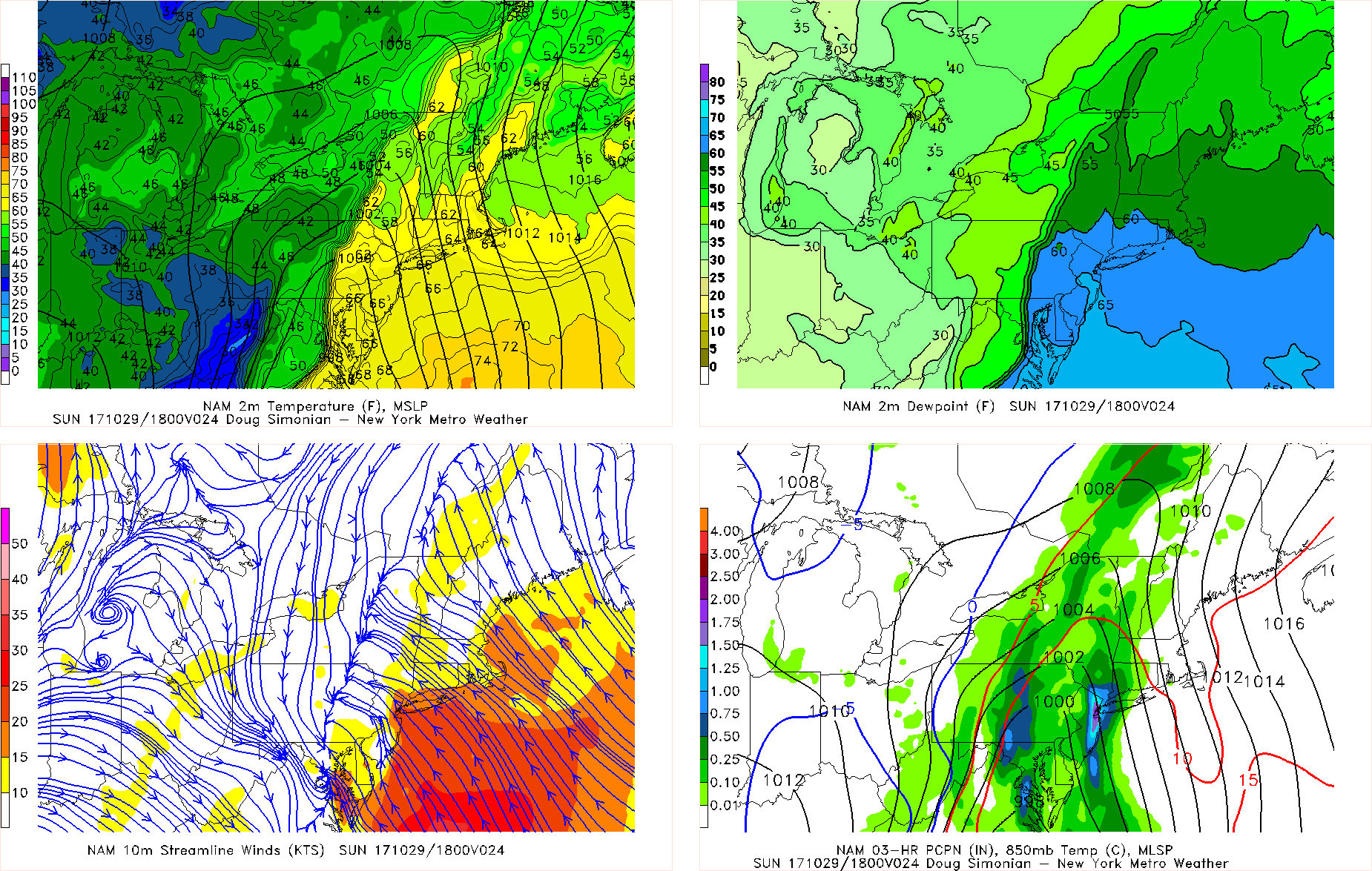
The NAM model showing extreme moisture convergence over the region on Sunday night.
Regardless, once the core of the storm approaches on late Sunday afternoon and evening, the result is an extreme scenario of the aforementioned second way to generate convergence, with the core of the 90-100 knot low-level jet with extreme moisture and even a tropical component rapidly decelerating once it hits land and enters the more stable core of the system. The red contours are moisture convergence, which is off the charts for most of the area, which will help result in torrential downpours. Any earlier subsidence in E PA or W NJ would easily fill in with very heavy rain. But again, notice how the convergence lessens as you head east, and considering the westward trend in the forecast models, that convergence may be even less for areas of Suffolk County. This means that the areas with the heaviest rain may not coincide with the areas that receive the strongest winds. Thus, a good chunk of Suffolk County into Eastern CT may only receive rainfall amounts around 1-2″, while Nassau County through NJ, NYC, most of Upstate NY and PA (besides the potential for reduced amounts in localized areas of E PA and W NJ from subsidence earlier in the day) will receive 2-4″ of rain, with locally higher amounts of around 5″.
A dry slot will arrive for most of the area by around midnight Monday morning, though the west side of the storm in more inland areas may see some wraparound heavy rain bands as the temperature gradient will remain very strong in those areas even once the moisture convergence lessens. A few showers may linger through Monday morning, before things taper off on Monday afternoon.
On Sunday morning, we will have wind gust maps for the area broken down into two time periods: Sunday night and Monday morning. But right now, a good estimate would be that the western half of New Jersey may only see wind gusts between 25-35 mph with Sunday night’s round, the eastern half of New Jersey may see wind gusts between 45-55 mph with that round, NYC may see gusts between 50 – 60 mph, and Long Island may see 60 – 70 mph wind gusts, with gusts locally up to 80 mph in some coastal areas of Suffolk County. For Monday morning’s round, it may be a more uniform 40 – 55 mph, with the highest readings potentially being in the more inland areas that received less wind on Sunday night.
Stay tuned for more updates over the next 12 to 24 hours!
This article was written by Doug Simonian, Miguel Pierre, and John Homenuk.
Trackbacks & Pingbacks
2exemplar
Comments are closed.