-2")
Mild and Dry Conditions Settle In, Signs of Change?
Good Evening!
Today was a nice start to the work week as an area of high pressure moved over the East, which prompted an increase in temperatures and calmer conditions over the entire Northeast. Much of the day was characterized by a mix of sun and clouds as a cool mid level airmass from Canada moved south on the heels of a weak cold front. This cold front is relatively weak and does not have any substantial moisture associated with it, thus any showers or flurries were extremely isolated in nature and did not last long. Otherwise, most of the New York metro area saw highs in the upper 40’s to lower 50’s, with lower to middle 40’s further north and west. These temperatures are just around normal for this time of year, with only a couple stations going slightly above normal.
The rest of the evening should remain quiet and cool as the high pressure remains firmly planted in place over the Tennessee valley. With the recent cold front passage, dewpoints have lowered and winds have also dropped a bit. This will set the stage for some stout radiational cooling to take place across the Northeast despite some warmer air in the mid levels trying to creep in overnight. Lows should be able to drop into the middle 30’s for the immediate New York City area, with upper 20’s and lower 30’s likely for the suburbs. Locations well to the north and west may see more efficient radiational cooling this evening, and could even drop into the upper teens and lower 20’s.
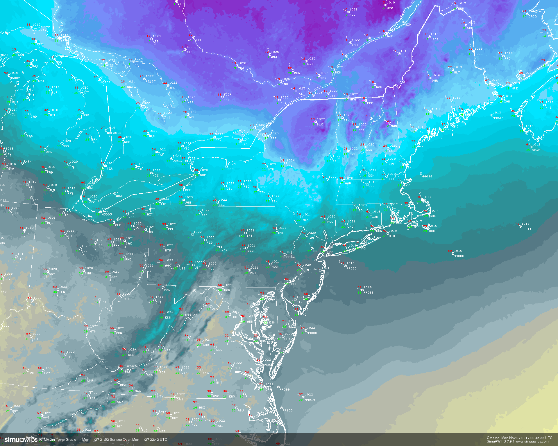
Real Time Mesoanalysis Temperatures for the Northeast this evening showing an impressive gradient over the area. Notice readings in the middle teens over northern New England , with 50’s closer to the coast! (Courtesy of Simuawips.com)
Tuesday Into Thursday
Tuesday will likely start of with clear skies and cool conditions area-wide, as the area of high pressure located to our south begins to move over and east of the region by the morning commute. The center of the high pressure will likely be situated just off the coast through the morning and into the afternoon hours, and this should introduce more southwesterly winds in the mid levels of the atmosphere. These southwesterly winds should be capable of ushering a warmer airmass over the region, but the degree of this warmth should be muted somewhat by return flow from the Atlantic. This should keep highs in the area mild, but not too warm. Expect temperatures to get into the lower to middle 50’s during the afternoon hours tomorrow, with some locations having a shot at middle to upper 50’s near the coast. Calm conditions should last throughout the day, with warm air advection increasing once again by the time we head into the overnight hours. With the high pressure located offshore and warmer mid level temperatures working their way in, expect lows to be warmer tomorrow night with readings likely in the upper 30’s to lower 40’s, with some locations north and west staying in the 30’s.
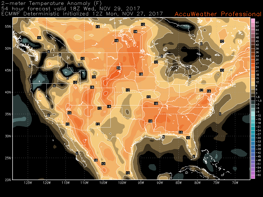
Wednesday looks to be a full-on above normal day as the strong southwesterly flow begins to surge northwards during the day. Mid level dry air will be present tomorrow afternoon, and this will help warmer mid level temperatures to reach the surface and cause highs to rise into the middle to upper 50 across much of the New York Metro area, with some locations closer to the coast possibly getting to the 60 degree mark by the afternoon hours. As the day goes on, another weak cold front looks to push through the area. This front should be another moisture starved front, so any showers will be isolated and weak in nature.
By Thursday, we see the pattern across the United States become rather progressive and zonal in nature, meaning that the jet stream will be flat and west to east oriented. This will allow the high pressure behind the cold front to quickly move offshore, providing more return flow from the south once again. This time there should be more Gulf moisture involved with this flow, and this should only increase as another disturbance works its way east across the country. The system should be located in southern Canada by Thursday evening, with a cold front extending down into Pennsylvania. Light to moderate showers will likely extend along this front as it moves through the Northeast, with only minor rain accumulations expected.
The rain should quickly head offshore by the early morning hours of Friday, with improving conditions thereafter.
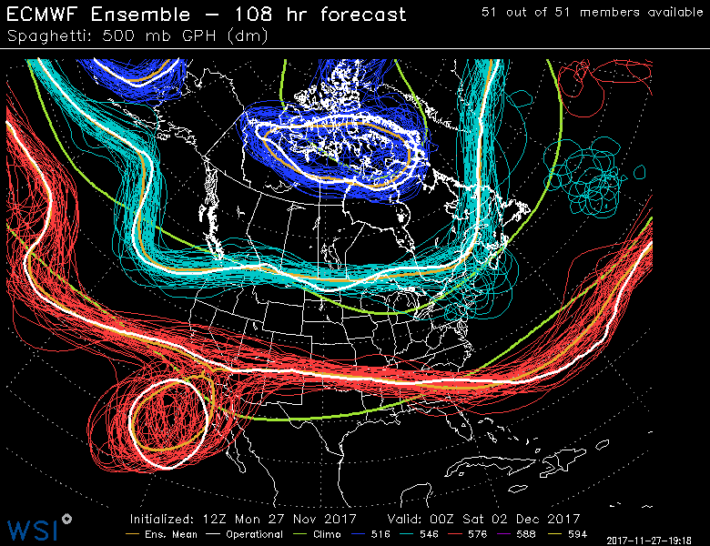
This afternoons ECMWF ensembles showing the rather flat nature to the pattern over the US, leading to rather calm and mild conditions.
Major Long Range Questions
Some of you have likely heard the buzz on social media that this boring weather pattern is likely to change and snap into a colder and potentially stormy one. While any potential pattern changes are a long ways out, we do have to mention that there is a growing consensus among the more reliable long range computer models that pattern across the Globe will shift to one that is much more supportive of at least a brief period of below normal temperatures across much of the country. This period looks to start during the second week of December and could possibly continue into the rest of the month depending on how other larger factors behave. At this time, we think that the models do have a relatively good grasp on the pattern at hand, and other outside factors like the MJO, and Stratosphere support the ideas being put forth by these models. We will continue to monitor this potential change as it moves up in time and will provide updates on any developments when they come up!
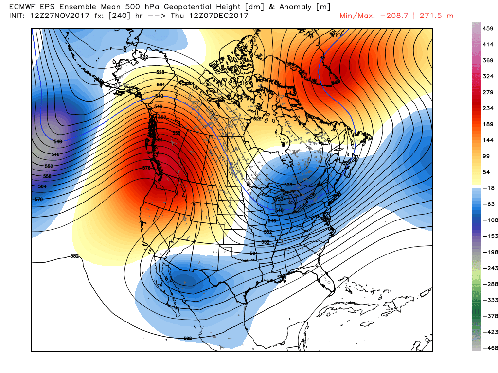
This afternoons ECMWF ensembles showing a major change to a much colder pattern with the potential for some winter weather threat to take shape by the middle of the month.
For more information and posts like this one, make sure you sign up for Premium Forecasts — where multiple detailed articles, videos, and interactives are posted each day. Also, come interact with our staff and many other weather enthusiasts at 33andrain.com!
Have a great night!
Steve Copertino
Trackbacks & Pingbacks
2signatures
Comments are closed.