header

Rain Exits Tonight, Active New Year’s Week Ahead

Good evening!

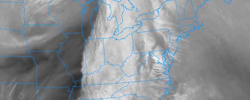
As expected, today has been yet another dreary and rainy Friday for much of the East Coast. In fact, this has been the third Friday in a row that has featured heavy rain and mild temperatures. Unfortunately, that streak looks to continue, but we will have more on that later.

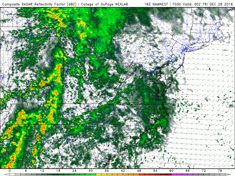
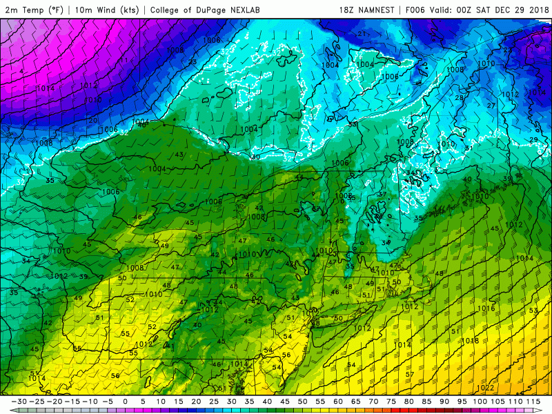
As of 5 pm, most of the left-over heavy rain was located just off the New Jersey coast and gradually moving to the east/northeast. While most of the metro area will begin to see precipitation tapper off from west to east in the next few hours, portions of eastern Long Island will likely see periods of moderate to heavy rain until the early evening hours. Stout southwesterly flow has been over the Mid-Atlantic and Northeast since early this morning, and temperatures have since been able to shoot up into the middle to upper 50’s across much of the area- with even some 60 degree readings showing up over portions of southern New Jersey. Needless to say, these highs are well-above normal for this time of year, with readings coming in anywhere from 18-24 degrees above-normal!

Mild temperatures and the chance for a light shower or two will last well into the overnight hours tonight as the cold front associated with this system lags well off to the west over the Ohio Valley. Lows tonight will be very mild, with temperatures staying in the middle to upper 40’s for much of the area. Temperatures across southern New Jersey could stay well into the 50’s into the early morning hours of Saturday.

In addition to the chance for some leftover showers this evening, low-level moisture will also contribute to some foggy conditions across the region before more windy conditions take over. Please use caution while traveling tonight, as some locations could see locally dense fog.

7-day forecast

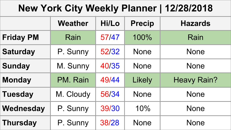
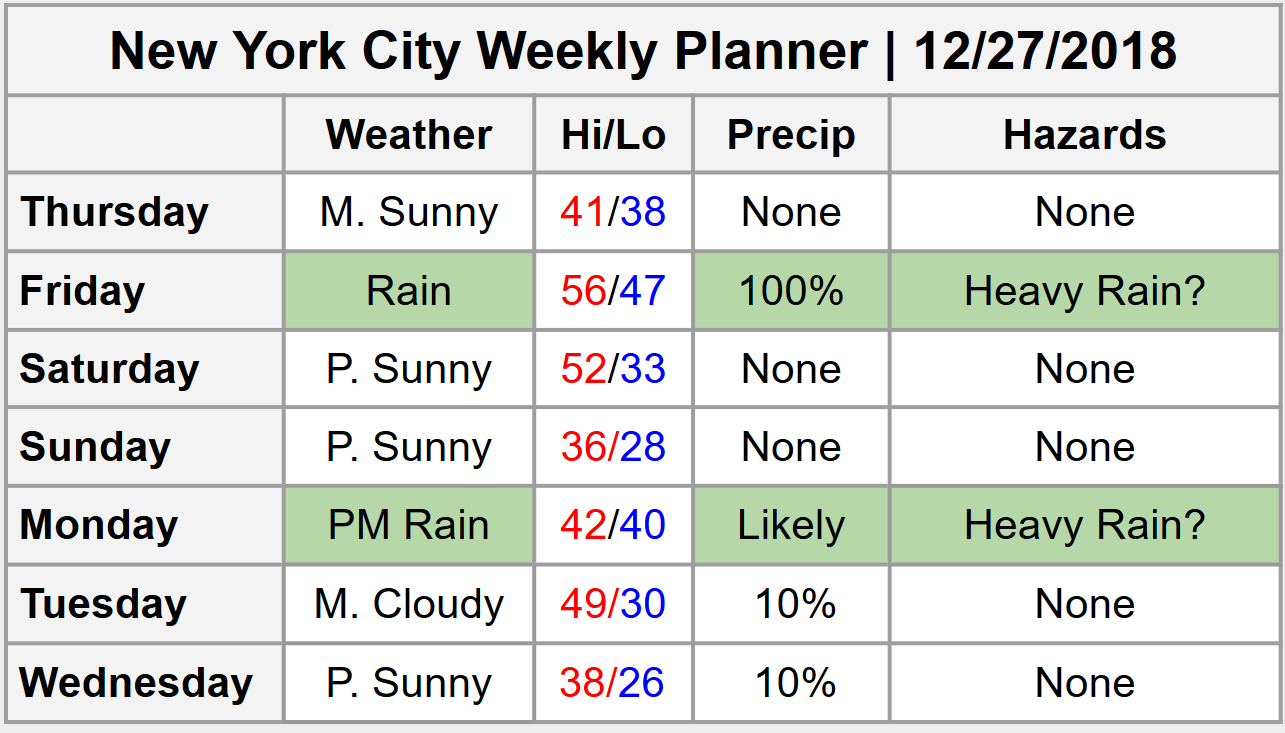
~Updated Weekly Planner~

Cold Front Finally Arrives Saturday, Another Storm Develops Late Sunday

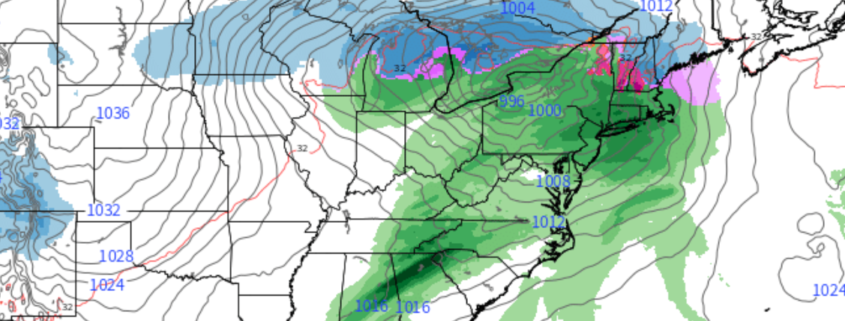
Saturday will likely start off rather mild across much of the Mid-Atlantic and Northeast as a cold front to our west slowly limps towards our area. High temperatures will likely be reached during the early morning hours, with readings likely reaching the middle to upper 40’s–with 50’s possible closer to the coast. Leftover low-level moisture will likely contribute to partly cloudy skies during the days, but should gradually decrease as we head into the late afternoon and evening hours. The much-anticipated cold front will finally move through our area by 3-5 pm, which should feature increasing winds, sharply falling temperatures, and decreasing dewpoints. These gusty winds and decreasing temperatures will last into the evening and overnight hours, with lows getting back down towards seasonable levels. Expect temperatures to bottom out in the middle to upper 20’s, with lower 30’s in and around the city.

Thankfully, Sunday looks to be the “gem” of this forecast period as it will feature mostly sunny skies and seasonable temperatures in the middle 30’s to lower 40’s for the entire forecast area as an area of high pressure build in over the east. Mid-level flow will be increasing from the west, so we cannot rule out a few passing clouds during the day, but the overall forecast for Sunday looks quite pleasant. Unfortunately, our next storm system will be gathering out over the Southern Plains late in the day Sunday night, with showers and thunderstorms likely beginning to increase over the Arklatex region.

NAM 3km Temps

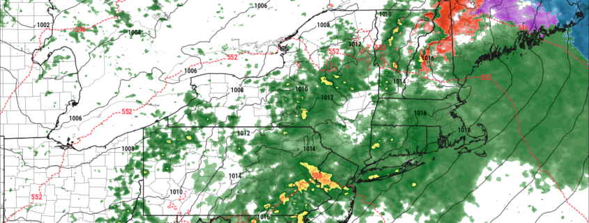
This evenings NAM model showing the progression of the weak cold front set to move through the area on Saturday

Dreary and Dismal New Year’s Eve Likely

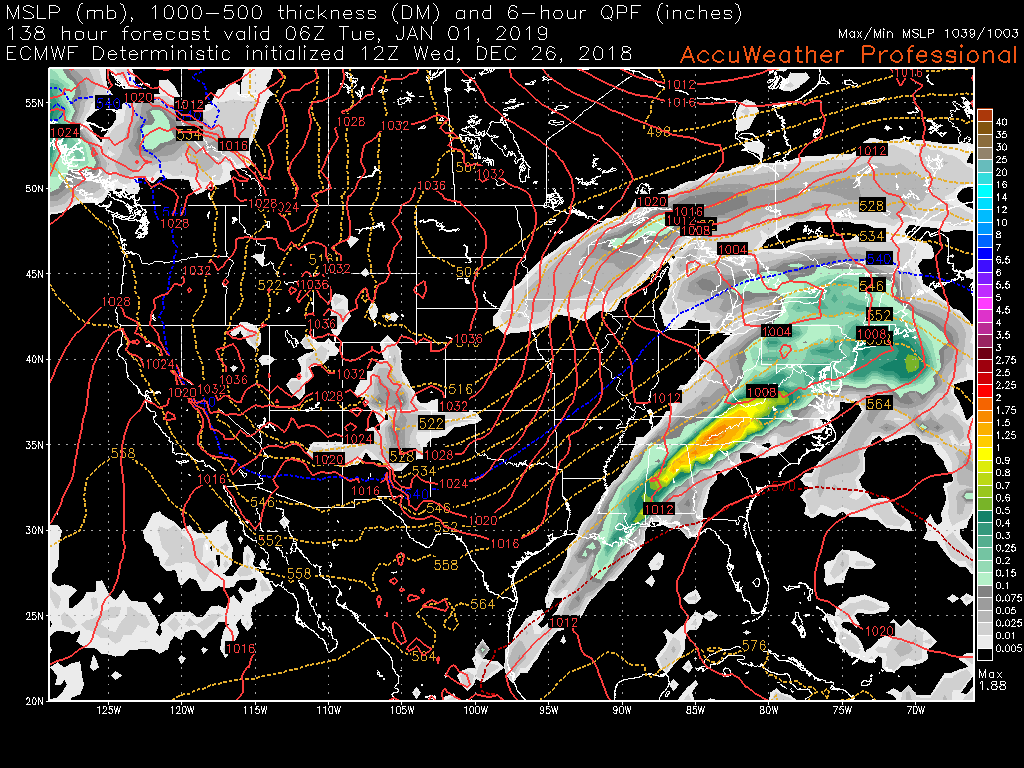
At this time, it is unfortunately looking likely that the system that will develop over the South late Sunday and into Monday will impact the New York City area on New Year’s eve with the potential for yet another chance at heavy rain-a fitting end to one of the wettest years in record. Clouds will gradually increase during the afternoon hours on Monday as yet another strong push of southwesterly flow moves into the region. As the day progresses into the late afternoon and evening hours on Monday, the main surface low will begin to push through the Ohio Valley, with a large area of steady rain overspreading the region by 5-8 pm. Conditions will continue to gradually go downhill as a low-level jet transporting moisture from the Gulf of Mexico will be overhead by this time as well. This will set the stage for heavy rain to potentially move through the NYC area just in time for the New Year’s celebration in Times Square as temperatures begin to rise into the middle to upper 40’s. The rain should gradually begin to tapper off from west to east during the very early morning hours of Tuesday, with mild temperatures holding on throughout the night.

As if things couldn’t get any more bleak, this afternoon’s models have been keying in on yet another disturbance making its way towards our area late next week just in time for (you guessed it!) Friday. If this system were to happen the way the models show, this would be the fourth Friday in a row which featured at least moderate to heavy rain!

Details for this potential system are very hazy at this point in time, but we will continue to monitor it over the coming days!

ECMWF 6-hour Precip

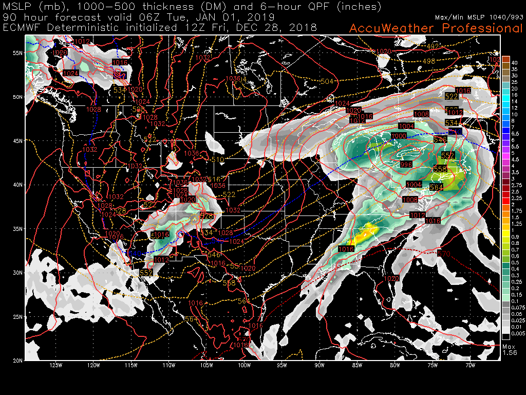
This afternoons ECMWF model showing yet another heavy rain event for New Year’s eve

We hope everyone has an excellent weekend and we will have an update on the upcoming system on Monday! 

Steve Copertino


NYC Area Forecast: Another Rainy Friday

Briefing: Rain expected this morning, with periods of heavy rain through the early afternoon. Localized flooding possible.

If you’re thinking it has rained on Friday a lot recently, you are thinking correctly. It has rained on the past three Fridays, actually, and we’re gunning for four today. A low pressure system moving into the Great Lakes is bringing warm and and plenty of moisture with it, and the result will periods of showers throughout the morning today. These are expected to continue for the majority of the morning hours.

Read more

Fire at ConEd Plant in Astoria Turns NYC’s Night Sky Blue

An explosion at a ConEd plant in Astoria, Queens caused the skies over New York City to turn bright blue on Thursday evening. The ConEd plant is located on 20th Avenue near Lawrence Point, in the Ditmars-Steinway portion of Queens. The bright lights were seen throughout New York City and New Jersey, and were captured by thousands on social media.

Read more

Another rainy end to the week, unsettled pattern extends into 2019

Good morning! Today should start off quite similar to Wednesday, with temps in the upper 20’s and lower 30’s for the morning commute. The aforementioned high pressure system will be moving through southern Canada and portions of New England this morning and into the afternoon hours, which should allow for near-identical conditions as on Wednesday. Temperatures should only be able to rise into the middle to upper 30’s for most of the area, with lower 40s possible for New York City and coastal locations.

While we remain in a relatively cold and dry pattern today a large area of low pressure over the Northern Plains will be dumping heavy snowfall and blizzard conditions in addition to heavy rain and thunderstorms over the Southern Plains. As this system strengthens and heads through the middle of the United States today, the northwesterly flow we’ve had for the past couple of days will shift to a more southwesterly flow. As with the two previous systems that we have seen cut to our west, this means that copious amounts of moisture and warmer temperatures will not be too far behind. The warm front associated with this system does not look to push through the region until after 8-10 pm, meaning any precipitation will likely hold off until later in the night. Light rain showers should be common into the overnight hours with the potential for some light mixed precipitation exclusively for elevated locations well north and west of the NYC area.

~Updated weekly planner~

Any mixed precipitation will quickly change to normal rain very early Friday morning as strong southwesterly flow overspreads the entire Mid-Atlantic and Northeast. Another anonymously moist airmass will be in place just in time for the Friday morning commute, which will likely feature steady rain and winds out of the south. Temperatures on Friday will get rather mild, with highs likely reaching into the lower to middle 50’s for almost the entire forecast area-with a shot at some readings at or around 60 degrees across coastal sections of New Jersey.

Moderate to locally heavy rain will continue throughout the afternoon hours on Friday, with a chance at some localized flooding issues for locations with poor drainage. The rain will gradually tapper off from west to east on Friday evening as the associated cold front lags well off to our west over the Ohio Valley. Temperatures will stay very mild for the overnight hours Friday and into early Saturday morning with lows  in the upper 40’s to middle 50’s (warmer temps will be located to the south and east of the city).

NAM Sim Radar

This evenings NAM model showing the progression of moderate rain developing late Thursday night and lasting through much of the day on Friday

Drier conditions over the weekend and more unsettled for New Years Eve

This weekend should start off quite pleasant as the cold front and associated northwesterly flow lagging behind Fridays storm system finally pushes through on Saturday. This will lead to increasingly sunny skies and falling temperatures throughout much of the day, with temps going from the middle to upper 40’s in the morning, to upper to middle 30’s by the afternoon hours. High pressure will also be building back into the East late in the day on Saturday, which will cause low temperatures across the entire area to drop to seasonable levels. Expect lows in the upper 20’s to lower 30’s for the vast majority of the metro area.

By Sunday we’ll likely be watching a weak/strung-out piece of energy that gets left behind over the Southern Plains from the previous system. While yesterday’s afternoons model guidance severely diverges on the ultimate evolution of this system, there is a low possibility that this system is able to organize somewhat during the early morning/afternoon hours on Sunday over the Ohio Valley and produces a very light area of precipitation over portions of the Mid-Atlantic. Due to the very fast flow that will likely be in place over the Northeast and the lack of blocking to allow this system to slow down and significantly organize, this system has a very low ceiling for its potential impacts. In fact, the latest guidance overnight and this morning, has this system much weaker and staying to the south, for these reasons. So we have taken precipitation out of the forecast for Sunday.

Things begin to get more unsettled as we move into New Years eve and New Years day. Wednesday afternoon’s European model showed a large trough digging into the Western half of the country, which would cause another area of low pressure to pass off to our west and likely produce more rain and mild temperatures to close out 2018. Some of model guidance did show this system getting suppressed to our south, which would have increased the chances of seeing some more frozen precipitation. But most models this morning are now showing this system tracking to well to northwest as like the European model. The main point to take away here is that this time period seems increasingly likely to feature unsettled conditions with more rain likely arriving New Years Eve afternoon and night. This system will begin moving away with some clouds and perhaps some spotty showers left behind on New Year’s Day.

ECMWF 6-hour precip/temps

This afternoons ECMWF model showing the potential for yet another rainstorm to close out 2018

We’ll continue to monitor both systems over the coming days and we will have an update out by Friday! 

Have a great night!

Steve Copertino