-2")
More Volatile Pattern with Significant Storm Threats Into Next Week
Happy Wednesday! High pressure will be off the Northern-Mid-Atlantic coast with more light onshore winds today. Sunshine this morning will be fading behind more high clouds this afternoon, as mid-level warm air advection increases. Temperatures are expected to be a little cooler this afternoon with highs in the upper 30s to lower 40s. These temperatures closer to normal for this of time year.
Mostly cloudy skies are expected for tonight and Thursday, as mid-level warm-air advection increases, ahead of approaching warm front. Temperatures will actually hold steady this evening the slow rise into into the mid-upper 40s by Thursday morning. Highs on Thursday afternoon will be in the upper 40s to lower 50s. On top of the remaining snow pack, moisture levels or dewpoints will be increasing underneath inversion, leading to some areas of patchy fog and drizzle.
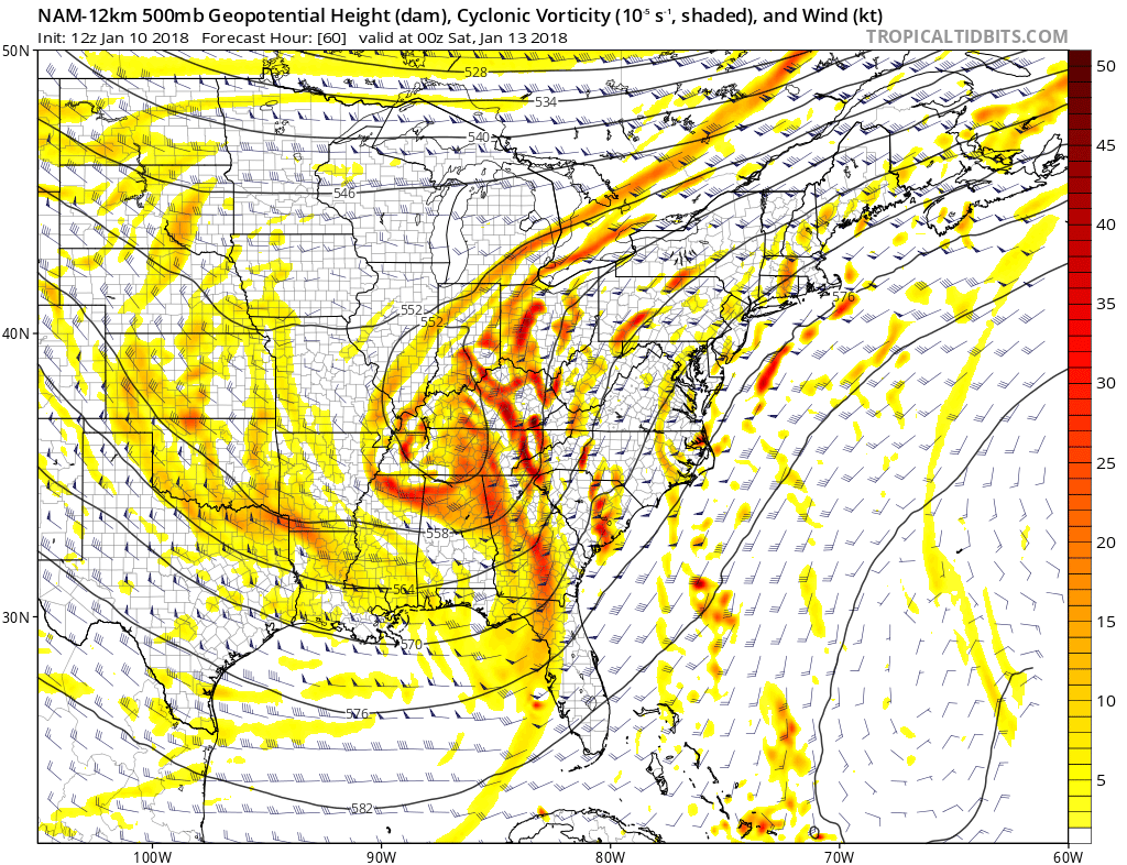
A stronger storm system will begin impact the Northeast and Mid-Atlantic late Thursday night into Friday and Saturday. Shortwave energy along large trough will be amplifying quickly over the Tennessee and Ohio Valleys, and in the right-entrance region of strong upper-level jet streak. Strong ridging will be building over the Western Atlantic and also force baroclinic zone to remain just inland. This will lead to a low to intensify and track near the Southern Appalachians on Friday and then track into New England on Saturday. While the models may continue to vary with their exact track and intensity of this low, most of the coastal plain, including the I-95 corridor from Boston to DC will be warmer side of this storm. In fact, temperatures may rise into the upper 50s or lower 60s in some locations by Friday night or Saturday morning.
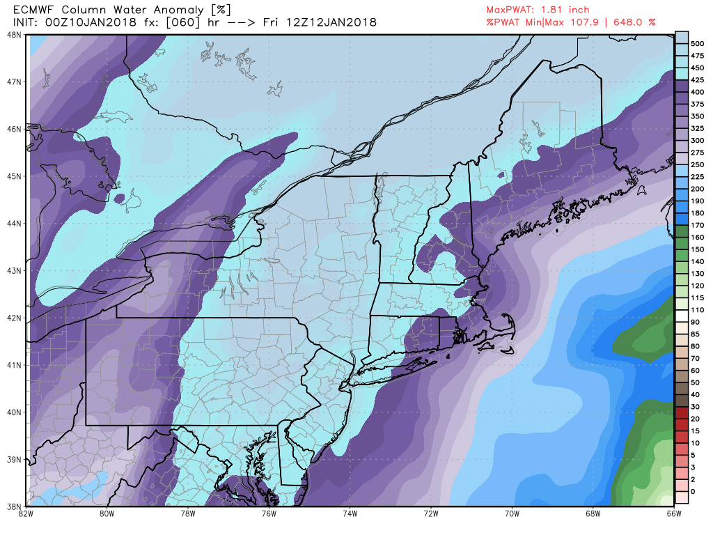
ECMWF model showing precipitable water values 400% above normal by Friday morning, support very heavy rainfall over parts of Northeast and Mid-Atlantic region
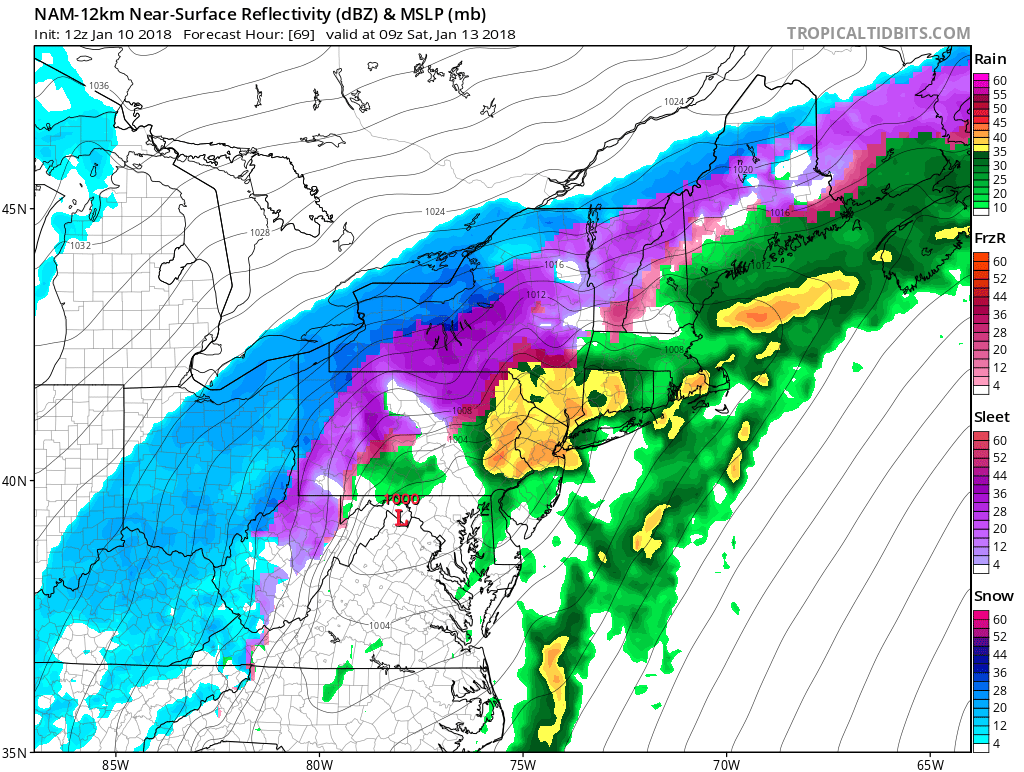
A period of rain is likely as a weak warm front and mid-level disturbance moves through late Thursday night and Friday morning. Then more rainfall arrives by Friday night into Saturday morning, with a stronger warm front moving northward with the low. Models are showing a strong southerly low-level jet with plume of subtropical moisture feeding into storm. Precipitate water values around 1.50 to 2.00″ are well above normal for this time of year. Therefore some of this rain will likely be heavy at times. A few isolated thunderstorms can’t be ruled again, with the warmer, unstable airmass. Rainfall totals of 1″ to 2″ are likely and some locally heavier totals are possible. The warmer temperatures, heavy rainfall and remaining snow pack that melts may lead some some minor roadway flood and along small rivers and streams. Some gusty winds near 40mph with strong low-level jet are possible along the coast.
Farther to the north and west of track large arctic high pressure nosing into Southeast Canada will allow for more cold-air to wrapping around this low as begins to consolidate. Thus more snow, sleet and freezing rain is possible the Interior parts of the Northeast. Some western and northern areas of New York State, Pennsylvania and New England may see some significant snow and ice accumulations by the time this winds down later Saturday afternoon. This could result more hazardous weather conditions, for anyone in these areas. It’s also not of the question that rain ends Saturday afternoon as light wintry mix or some snow showers down to the I-95 corridor and coastal areas as well. But no snow or ice accumulations of consequence are likely.
Then behind this storm, much colder, drier air will rush into the Northeast Saturday night and Sunday with some gusty winds likely. If you thought there will be a torch coming for next week, that won’t be the case yet. Instead a strong ridge build over the West Coast again leading to deeper, larger trough over Eastern US. This will support more arctic cold air over the Northeast and Mid-Atlantic again through the middle of next week. We are still monitoring additional shortwave energy rounding the base of the trough. Overnight run of the GFS model last night showed this energy phasing into closed low over the Northern Mid-Atlantic region. This resulted in a stronger area of low pressure developing along the Mid-Atlantic coast and producing more significant snowfall for parts of Northeast.
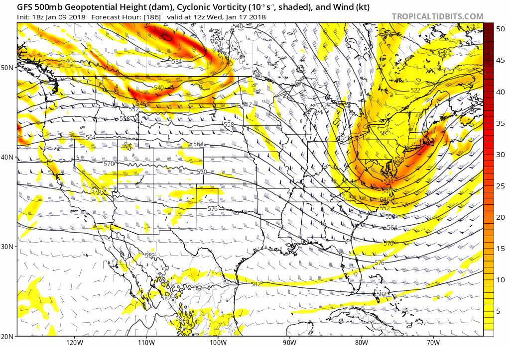
0z and 6z GFS models runs with 500mb heights and vorticity .The 6z run shows a more progressive solution than 0z run, where Pacific energy moves into Midwest collapsing he PNA ridge. Thus doesn’t allow for more trough amplification and shortwave phasing into a closed low over the Northern Mid-Atlantic region.
However, the latest run as of 6z early this morning has now backed of this, with a more progressive solution. The European and Canadian models are also more progressive with this wave low pressure and the most ensembles don’t support a stronger storm as now. So right now, this significant storm has very low probability of occurring next week, especially also considering the lack of high-latitude blocking over the Atlantic side. But we will continue to monitor how models handle ridging out west and mid-level vorticity hanging back with this trough. If the ridge remains strong while moving the over the Northern Rockies, then currently shown on the model and ensemble guidance, this will allow for the energy to phases, and winter storm chances here for the Northeast to increase. Stay tuned for more updates through this upcoming weekend!
Trackbacks & Pingbacks
2interim
Comments are closed.