-2")
Monday AM Briefing: Light Snow for Parts of the Northeast Tonight & Tuesday
Good morning! After a pretty mild weekend with more clouds and some rainfall on Sunday, much colder air begins returning for a few days this week. We also continue to watch a storm system for tonight and tomorrow. However, the latest model data and observation continue to point to a nuisance event for most areas at best.
First during the day today, plenty of mid-high level clouds will be around as low pressure near the Southeast US coast begins to organize and move northeastward. Best chance for some sunshine will during the late morning and early afternoon hours. Temperatures will still remain several degrees above normal. But it will feel chiller than compared over weekend. High temperatures will be in the lower to middle 40s.
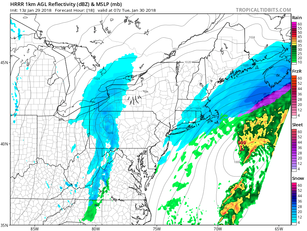
Then a fast moving mid-upper trough will cause this low to track well offshore, later tonight. This will keep the majority of the storm’s precipitation away from the Northeast and Mid-Atlantic region. But a mid-level shortwave and upper-level jet will be enhancing light to moderate precipitation on northwest fringe of this system. Surface temperatures will also be falling into the upper 20s to lower 30s with northeast winds. So some light snow is still possible later tonight into early Tuesday morning, mainly for coastal areas.
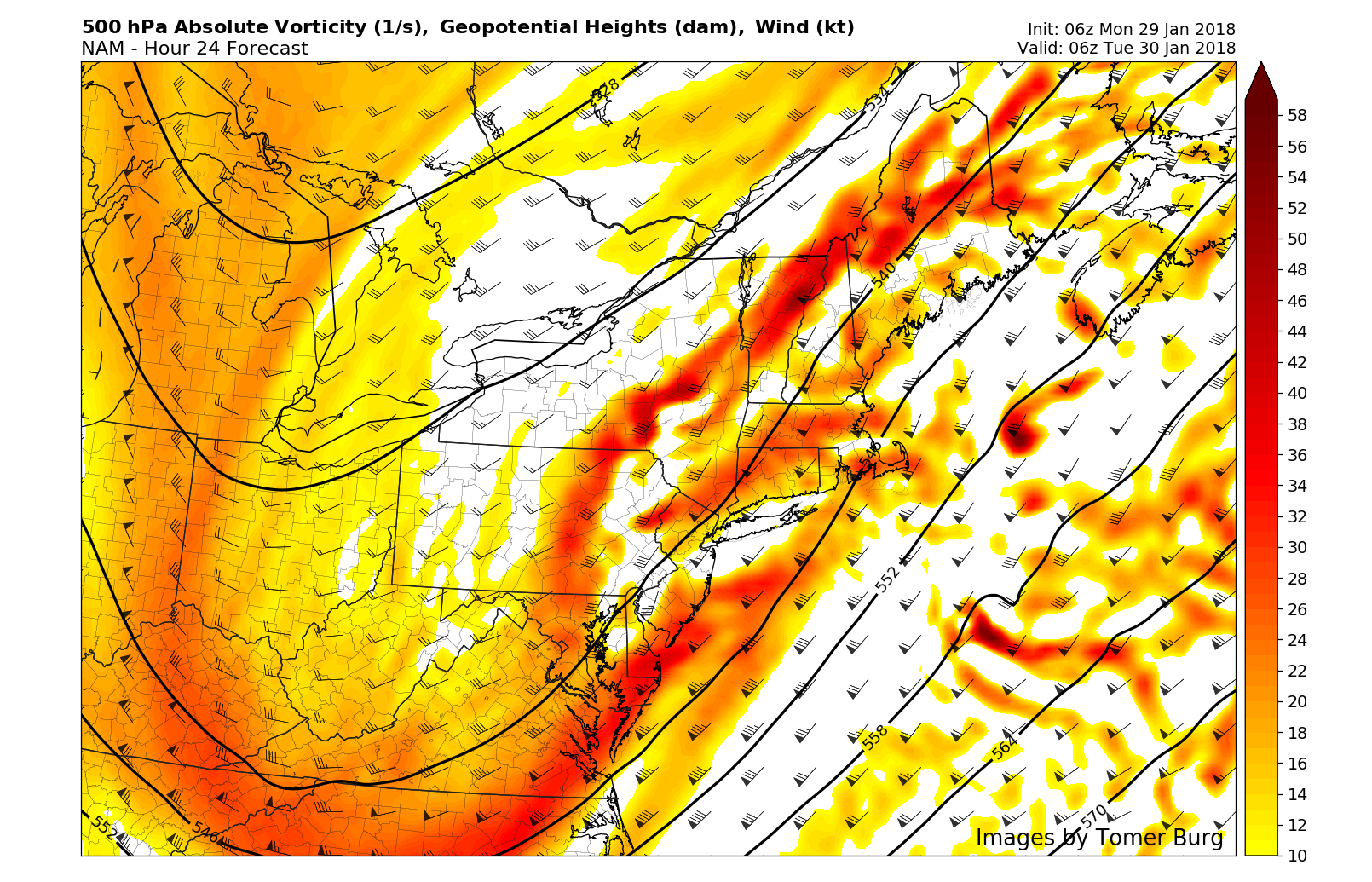
NAM model showing robust shortwave energy moving through Northeast with the upper-level trough late tonight.
Currently we anticipate no more than a trace to 1” of snowfall for most areas along and northwest of I-95 corridor. Over parts of Long Island, Southern Connecticut and along the New Jersey shore, there is better chance for some areas to receive between 1″ to 2 snow. Further east over Cape Cod and Islands, some bands of moderate snow could lead to a few inches more. However, there is some uncertainty on how far light snow will expand inland and if any heavier frontogenetic banding will occur. We should have better handle on accumulations, as new data comes in later today.
An inverted/norlun trough will also likely trigger some snow showers during late morning and afternoon hours on Tuesday. But this is expected to be mainly over Central and Eastern parts of New York State and Pennsylvania and perhaps into Western parts of New Jersey and Delaware. Some instability with steep mid-level lapse rates may even support some snow squalls with briefly moderate to heavy snow and reduced visibilities, resulting in some travel delays. Overall coating to 2” of snow will be possible with these snow showers or squalls. High temperatures on Tuesday will be in the mid-upper 30s.
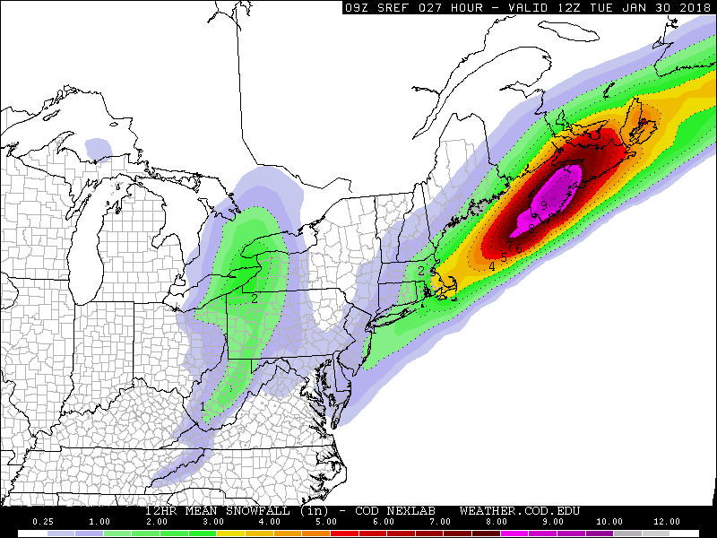
SREF mean snowfall totals through through 7am Tuesday morning over the Northeast
High pressure will support more sunshine but very cold weather again with highs in the lower to middle 30s for Wednesday. Which is just slightly below normal for late January. Then temperatures will quickly moderate into the mid-upper 40s on Thursday, with more southwest flow, ahead of a strong cold front and upper-level trough approaching from the west. More clouds and rain showers with this cold front may arrive in the Northeast by afternoon or evening hours on Thursday.
Then a period of snow or some snow showers are possible, as some cold air rushes in behind this front later Thursday night into Friday morning. Some light snow accumulations are still possible. But latest models have backed off a wave of low pressure developing along this front that would enhance more significant snowfall over the parts of Northeast and Mid-Atlantic. Instead high pressure builds with more seasonable cold and dry weather later Friday and Saturday.
Stay tuned for another update this afternoon or evening on the light snow threat for tonight and the forecast for the rest of week into the weekend.
Trackbacks & Pingbacks
2topography
Comments are closed.