-2")
Snowstorm increasingly likely in the Northeast this weekend
Good morning and Happy Friday! As many of us in the Northeast, and especially the Northern Mid Atlantic, make our way to work without a heavy jacket for the first time in what seems like months, the atmosphere is already undergoing a significant transition. Warm, humid air is entrenched in the region right now and a disturbance passed by overnight leading to heavy rain (and severe thunderstorms in parts of Pennsylvania, where it is believed a tornado touched down in Uniontown last night). A frontal boundary approaches and slides towards the coast later this evening.
Lurking back to the west is another disturbance which will emanate from the Pacific and track across the United States, ending in the Ohio Valley and Northeast states late Saturday into Sunday. The frontal boundary will have sunk southward towards the Mid-Atlantic Coast, allowing cold air to filter back in. And when the disturbance approaches this front, the temperature gradient will promote the development of low pressure. Increasing lift will lead to the expansion of precipitation – likely in the form as snow for many areas.
The low pressure will develop off the coast late Saturday Night with snow spreading northward, from the Washington DC Area towards Philadelphia and then eventually New York City. There are several uncertainties that still remain:
Precipitation Type
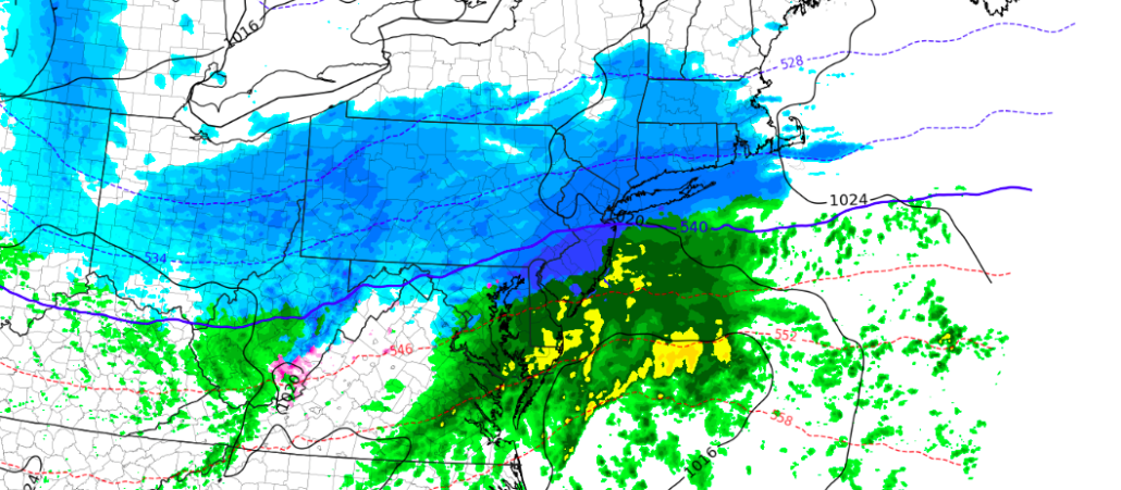
Precipitation type remains a significant concern and uncertainty (what else is new), and this is especially true to the south and east of the major cities (i.e, Long Island, New Jersey Shore, etc). Here, warmer air will remain entrenched at the surface – and the lack of a true cold air source or high pressure will make it difficult for snow to fall for a long period of time.
Here’s an important thing to remember: In order to get snow of significance in the coastal Northeast states, a cold surface high pressure is critical. With the warmer ocean waters lingering to the east and south, keeping cold air in place is a huge part of the forecast. This storm, synoptically, is not “Classic” for snow along the coastal plain by any means, as winds turn southeasterly during the storm and begin to draw in some of that warmer, maritime air. As a result, we anticipate that precipitation will flip to rain along the coast before the more steady snow begins and starts accumulating. The big cities and areas to the northwest, however, will fall along the gradient.
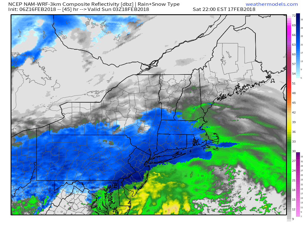
NAM model showing heavy snow throughout the Northeast early Sunday.
The gradient near the big cities will allow for the cities themselves and many areas just to the north and west of them to remain snowfall. If sufficient dynamics are present, the snow rates could actually be enhanced in these areas just to the northwest of the rain/snow line (what’s that classic line: “you have to taste the taint”). As a result, this is where we anticipate the heavier snow totals to be.
Atmospheric Dynamics
Heavily involved in any forecast for snow is the presence and evolution of atmospheric dynamics. This is the straw that stirs the drink, so to speak; what is going on in the atmosphere that is going to cause snow? Where will it be heaviest and why? In this particular storm system, there are a few conflicting signals to pay attention to.
Firstly, the synoptic setup in the mid levels of the atmosphere is not classic for snow in the Northeast States, especially the Northern Mid Atlantic. The best vorticity in the atmosphere’s mid levels tracks to the north and west and the surface low is spawned by energy coming in from the Ohio Valley.
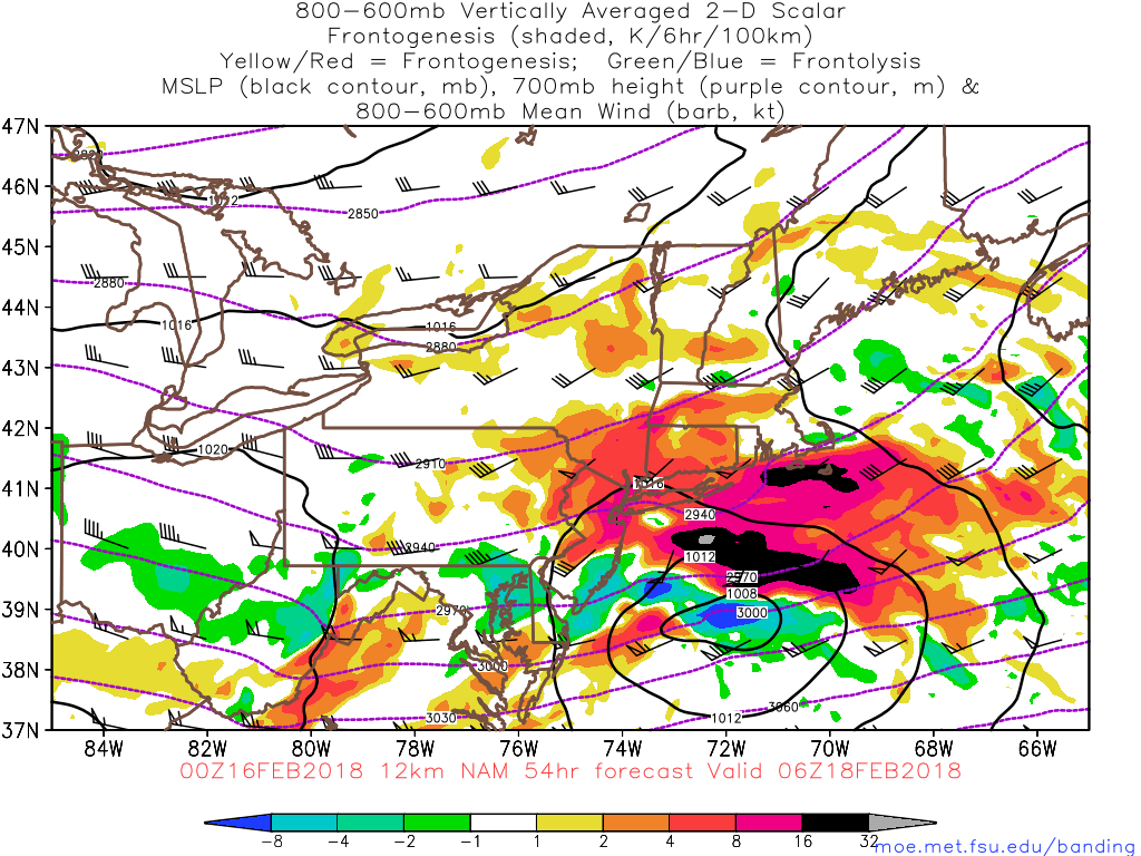
NAM model depicting frontogenesis, areas of enhanced lift, that can lead to heavy bands of snow. Reds, pinks and blacks depict the best lift.
With that being said, forecast models depict a very favorable and strengthening 250hPa (upper level) jet streak over New England and Southeast Canada. This is a major factor in allowing for precipitation to expand and properly vent – while opening up room for bands of heavier snow. A strengthening low level jet is also expected to aid in the development of increased moisture, which will allow the atmosphere to produce better low level dynamics and, as a result, heavier snow as well.
It is not surprising, then, to see models like the NAM producing bands of heavy snow as the storm system evolves. We currently feel the NAM is a bit too aggressive with this banding, but likely has the correct idea with how the system will evolve dynamically. Exactly how this occurs will be critical, especially for areas along the temperature gradient. Heavy snowfall and precipitation rates can cause dynamic cooling – essentially, the heavy rate of precipitation cools the air around it – and can flip rain over to heavier snow. We’ll be watching closely
Accumulations
The final piece of the puzzle is taking the time to put all of this together and discuss accumulations. Leaning towards the slightly more dynamic solutions, but away from the likely overdone heavy bands of snow, we can put together some ideas as to how the system will evolve. As we mentioned, we anticipate snow will break out from Saturday Night across the Mid-Atlantic and spread northwards into New England through early Sunday morning. Precipitation will likely change to rain to the Southeast of the big cities, especially near the coast, as warmer air becomes involved.
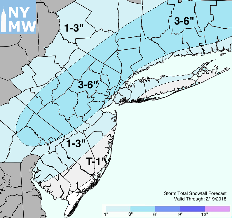
Storm Total Snowfall Forecast through this weekend.
Near the big cities, snow will fall and will be heavy at times. Accumulations may be limited, especially at the beginning, by warmer ground temperatures and surface temperatures near freezing as the snow falls. But eventually, the precipitation rate will take over and accumulations should occur – obviously on colder and grassy surfaces first. The snow will continue for several hours before wrapping up Sunday morning, obviously with New England the last to see flakes in the air.
Our forecast snowfall accumulation map takes into account all of the above factors, including ground/surface temperatures, precipitation type, dynamics, and some weighting of forecast model guidance. We’ll update this as we go along in the next 24 hours or so.
Have a great Friday!
Trackbacks & Pingbacks
2buckler
Comments are closed.