-2")
Wednesday Briefing: Major Nor’easter Impacts Friday & Saturday
Happy Wednesday! A major nor’easter will likely bring a myriad of moderate to significant impacts over much of the Northeast US on Friday and Saturday. For now, partly sunny skies and mild temperatures will continue this evening, with temperatures holding around 50 degrees. For tonight, skies will become mostly cloudy, as some high clouds will begin arriving from the west, keeping temperatures from dropping out of the 40s; but it will remain dry.
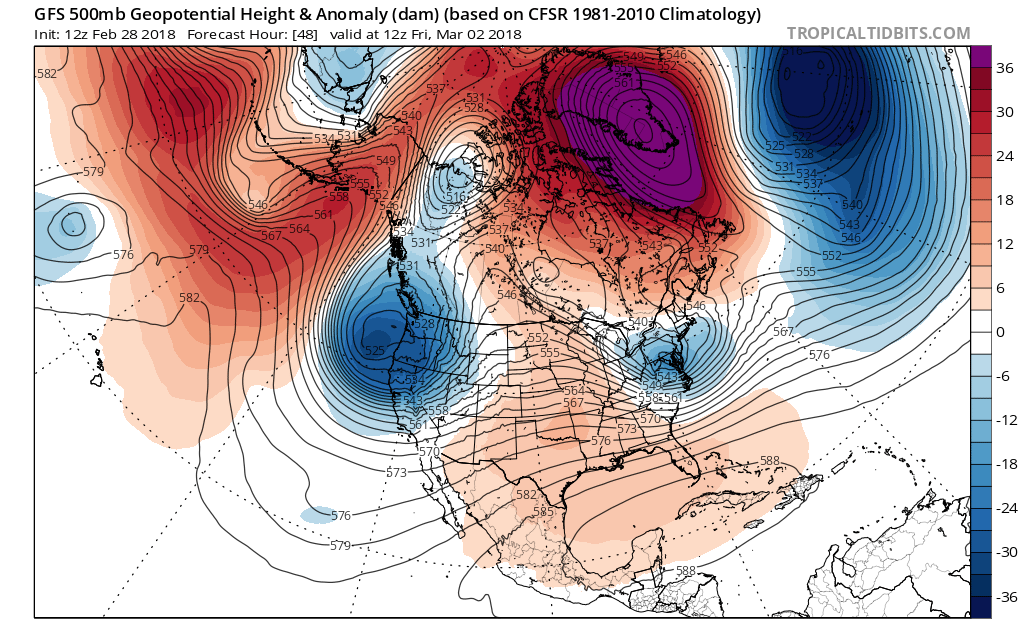
Then a large storm system will begin taking shape on Thursday. This is due to an upper-level trough amplifying, as ridging develops over the Central US as very strong, anomalous blocking moves into Greenland. The models show northern and southern stream energy interacting with each other along this trough. But there are run to run differences on how much phasing will actually occur. This is affecting how this storm ultimately evolves and impacts portions of the Northeast and Mid-Atlantic regions. Therefore, confidence is lower and uncertainty higher with some wintry and coastal impacts from this storm.
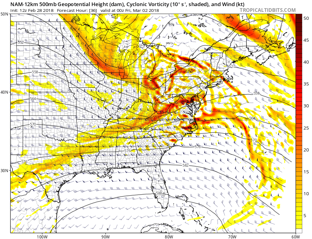
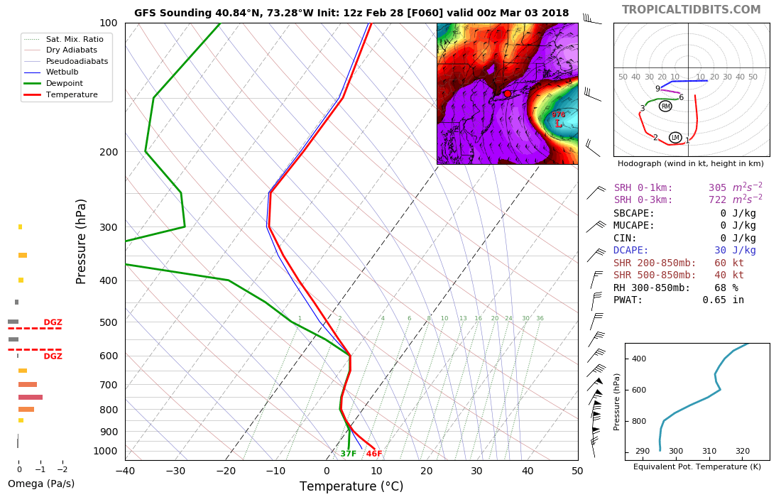
Northern stream shortwave energy over the Great Lakes phasing with shortwave energy over the Mid-Atlantic region, into a deep closed mid-level low just off the coast by Friday evening
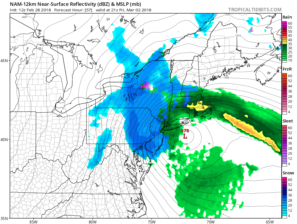
Surface low pressure will be tracking eastward over the Ohio Valley, with a warm front and a large area of precipitation extending further east. Initially, the airmass will be warm enough for rain over much of the Northeast as this storm approaches late Thursday afternoon and night. A strengthening easterly low-level jet with abundant sub-tropical moisture from the Atlantic will lead to rain — possibly heavy at times — later Thursday night into Friday morning. Rainfall totals could be over 1.00″ in spots. This along with the soil already near saturated after some recent rainfall will lead to some localized flooding, especially in poor drainage or low-lying areas.
However, the primary low will weaken, as a secondary low will be forming just south of Long Island or New England on Friday. This secondary will intensify rapidly in response to the aforementioned shortwave phasing. Cold-air advection and dynamics will increase, causing rain to gradually mix with and then change to snow in parts of the Northeast on Friday. A cold-conveyor belt with some banding is likely to develop over the Interior areas first. Strong frontogenesis appears likely and will support more dynamic cooling with moderate to heavy snowfall over the highest elevations, including the Poconos and Catskills. Some significant snowfall (6-12”+) is most likely to occur in these locations.
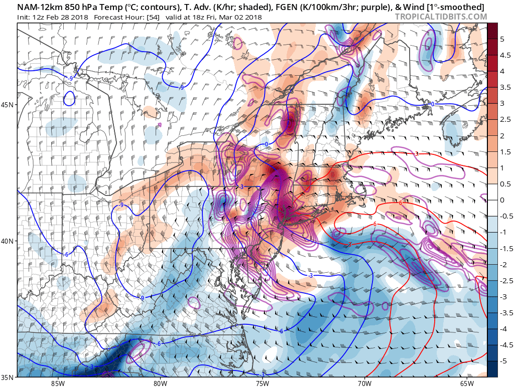
NAM showing strong dynamics (850mb frontogenesis with thermal advection) for moderate to heavy bands of snowfall, especially for inland areas on Friday
Then we have to monitor how far south and east this band moves later on Friday morning through Friday night. Some of the higher elevations over Northern New Jersey, the lower Hudson Valley and Connecticut, could see some moderate to heavy wet snow by Friday afternoon and night. Thus a significant snowfall 6″+ is not out of the question for these areas. Boundary level temperatures will be too warm for snow initially, especially for the I-95 corridor and coastal areas, until winds switch to a more north-northwesterly direction later Friday afternoon.
At this time, some light to possibly moderate snowfall accumulations seems mostly likely for parts of the New York City and Philadelphia Metro areas. But roads are likely remain mostly wet or slushy with marginal surface temperatures. Over much of Long Island and other coastal areas, more marine influence and mid-level dry air very close to the low will reduce the potential for any substantial snow accumulations. We should have more details on snowfall accumulations in parts of the Northeast by Thursday.
However, the latest model trends have delayed the initial phase between the northern and southern streams, which means the flow becomes less amplified, and thus not as warm. Afterward, they have then become more aggressive with a secondary area of stronger northern stream phasing, which brings more colder air into the storm, and also more dynamics. The phasing timing itself so that it occurs closer to our coast means the storm can mature, peak in intensity, and thus stall right off the coast, rather than further away from our area. If this is the new trend, then more snow would have to be added to the forecast, as this idea could result in several inches or more of snow even down to the coast via pivoting, stalling heavy snow bands.
Another significant aspect of this will be the threat for strong winds and tidal flooding near the coast. Current models indicate the most damaging winds and coastal flooding may over the New England coast, with a strong easterly low-level jet on Friday. But blocking over Greenland will force this storm to track south and then southeast from New England into the Western Atlantic during the weekend. A strong pressure gradient between a 1030mb+ high pressure over Southeast Canada and this storm still lurking offshore, may lead to some stronger north-northeast winds Friday night into Saturday.
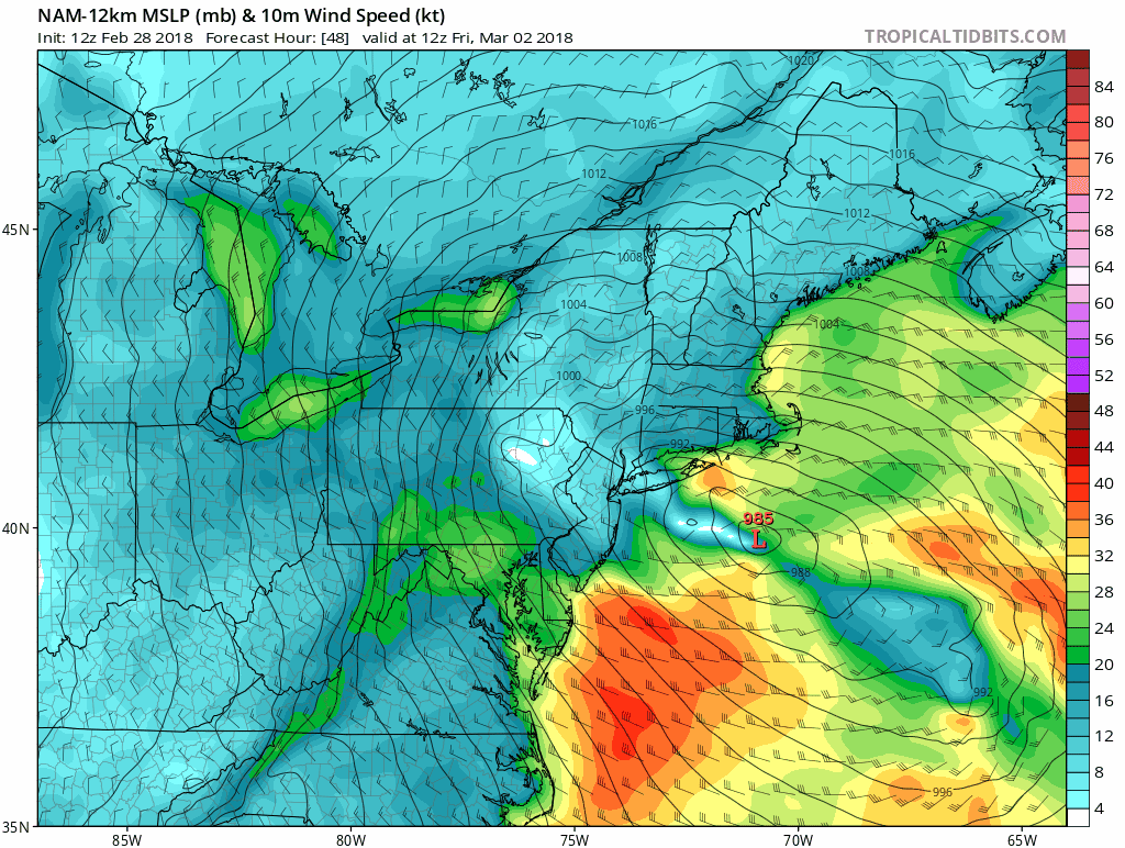
NAM model showing strong sustained winds along the coastal areas, resulting in some significant flooding during the high tides through Friday and Saturday
Model soundings also indicate steep lapse rates or instability, allowing for some stronger winds aloft to mix down. Thus more locally, winds gusts between 45 to 60mph are possible on Friday and Saturday. Some minor to moderate coastal flooding is likely during the high tides through at least Saturday. This is due to strong onshore winds and higher tides with the full moon. There is a chance of some locally moderate to major flooding, as water continues to pile up in some back bays along the south-facing shores of Long Island.
All precipitation should begin to wind down on Saturday, as the storm begins to undergo occlusion as it moves further out into Atlantic. More sunshine is expected by Sunday with temperatures rising into the mid-upper 40s. Temperatures will stay several degrees above normal with a strong ridge over Northeast. But another coastal storm with perhaps more significant wintry precipitation is lurking for the middle to later part of next week, as the Greenland block begins retrograde, erode and more ridging amplifies over the Western US.
Stay tuned over the next few days for more updates on the Nor’easter for Friday, and the potential coastal storm next week!
Trackbacks & Pingbacks
3retailer
Comments are closed.