-2")
Significant winter storm set to affect the Northeast on Wednesday
A powerful storm system is expected to evolve over the next few days in the Northeast states – the second in just under a week – as a strong disturbance drives southeastward from the Great Lakes and forces a powerful coastal low to develop offshore. Forecast models have trended stronger, deeper, and slower with the track of the storm, and as a result the impacts of the system are expected to be significant.
Impacts are expected to begin across the Mid Atlantic and Northeast states as early as tonight, with snow spreading northward along a frontal boundary as moisture begins to surge northward as well. But the main event will come on Wednesday morning, as impressive atmospheric dynamics reach the coast and touch off the rapid development of a low pressure system. This will send bands of very heavy snow inland through NJ, NY, PA, and CT, with significant snowfall accumulations and widespread travel impacts.
The main question with the system now has become the placement of heavy snowfall bands and the potential for precipitation-type changes as the storm develops. Recent models have tucked the storm closer to the coast, resulting in warmer air changing precipitation to rain and mixed precipitation across parts of NJ and Long Island – while the enhanced dynamics being closer to the coast enhance snowfall inland. Here’s how we expect the system to play out across the Northeast states, with a slightly more detailed focus on the NYC Metro Area:
Tonight
Snow develops slowly from south to north across the Mid Atlantic and Northeast, specifically in parts of New Jersey, Eastern Pennsylvania, NYC and Long Island. It may start as rain in some areas, but will gradually change to snow – and should slowly accumulate. This precipitation is actually associated with a frontal zone and increased moisture, the main storm will still be lingering to the south.
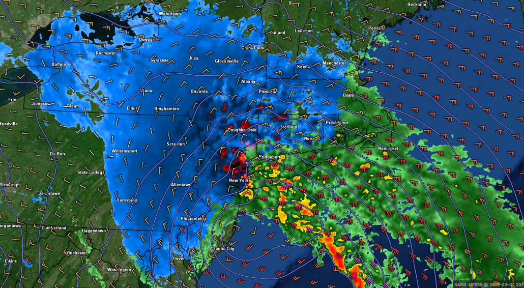
Tuesday’s 18z 3km NAM mode shows a batch of moderate snow moving through the region at 4:00am Wednesday morning (Tomer Burg)
Regardless, by daybreak, many areas will already have seen accumulating snow of significance, making travel difficult during the early morning and early commuting hours.
Wednesday Morning:
Conditions will rapidly deteriorate in the morning hours as the low pressure system offshore strengthens and tracks near the NJ Coast. Bands of heavy snow are expected to push inland – with intense snowfall occurring within them. Low visibility is expected with difficult travel conditions area-wide. The heavy snow will gradually push further Northwest into areas such as Northern NJ, Eastern and Southeastern PA, and Southeast New York State as well. Snow accumulations are expected to be significant during this time.
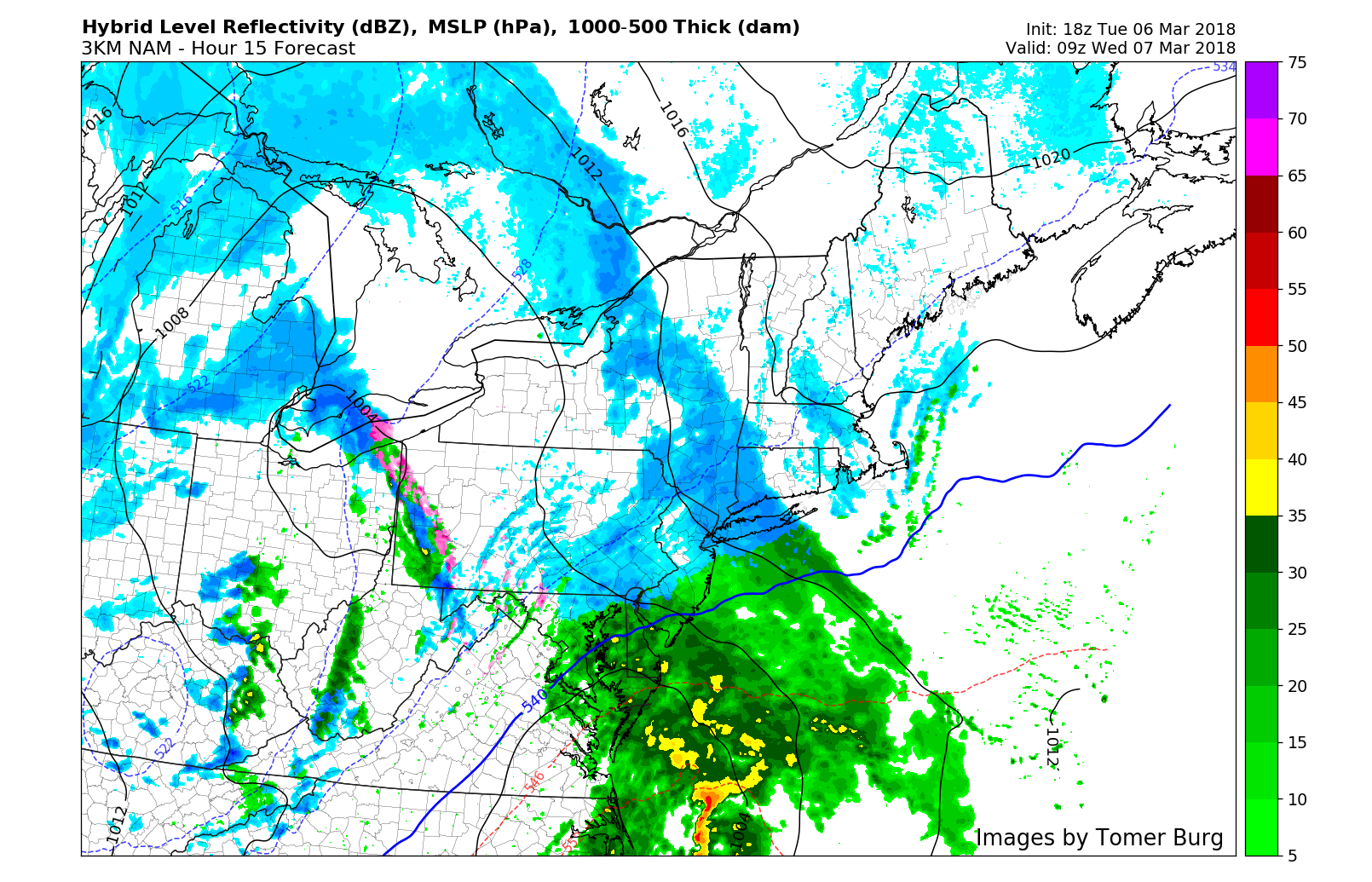
Tuesday’s 18z 3km NAM model valid for noon on Wednesday shows the very heavy band of snow in E PA and NW NJ, but mixed precipitation types closer to NYC and the coast.
Later in the morning, the snowfall will continue to grow more intense as atmospheric dynamics increase. This will be particularly true across Northern NJ, Eastern and Northeastern PA, and Southeast NY as well as CT. Meanwhile, the intense dynamics associated with the storm system are expected to bring mixed precipitation and possibly even a dry slot to areas such as Long Island and Southern New Jersey.
Wednesday Afternoon
Snow will continue to fall with significant accumulations across Northeastern PA, Northern NJ, much of Southeast NY, CT and New England. Snow rates are expected to be quite high in bands, which could produce whiteout conditions and extremely difficult if not impossible travel. These conditions are most likely to occur inland and away from the coast and I-95 corridor, but may also affect those regions at times as well.

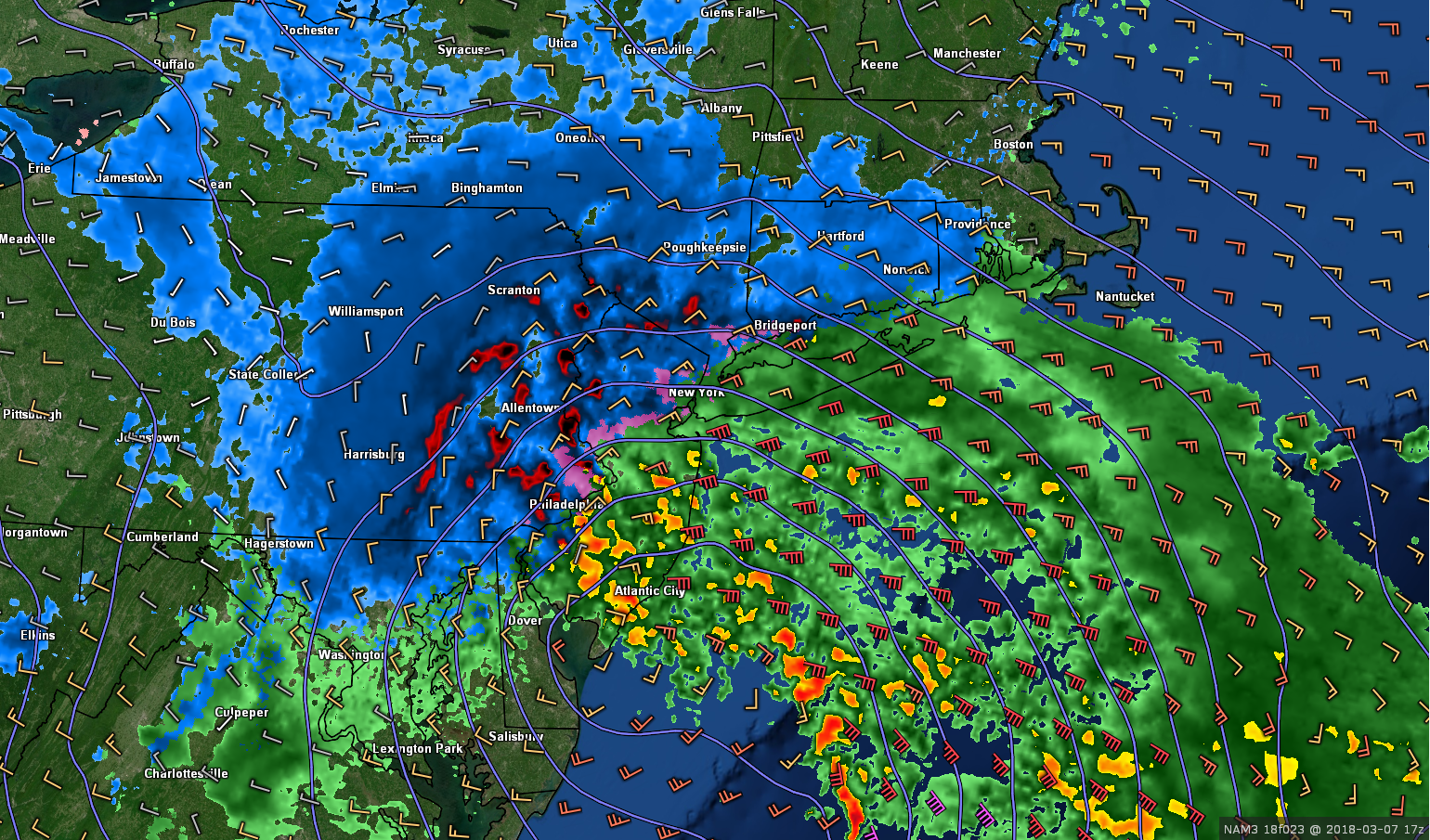
Tuesday’s 18z 3km NAM model valid for 3:00pm on Wednesday shows a dynamically driven area of precipitation allowing NYC to change over to heavy snow, while areas further west keep the classic banding. The immediate coast still has mixed precipitation.
On Long Island, in Southern/Coastal Connecticut and along the New Jersey Shore, precipitation is expected to become mixed or change to rain for periods of time during this time frame, with the additional potential for a dry slot, or an area of drier air aloft that reduces precipitation intensity or ends it entirely. Snow is expected to continue inland and away from the coastal plain as this occurs (this will result in lower snowfall totals in Southern/Eastern areas).
Wednesday Evening
The storm begins to track to the South and East of Long Island during this time. Additional bands of heavy snow are likely to rotate and “curl” inland towards the low pressure (known technically as the development of a cold conveyor belt” and this will bring additional bands of heavy snow to places like Northern NJ, Southeast NY, NYC and CT. Winds will also pick up during this time frame as the pressure gradient increases.
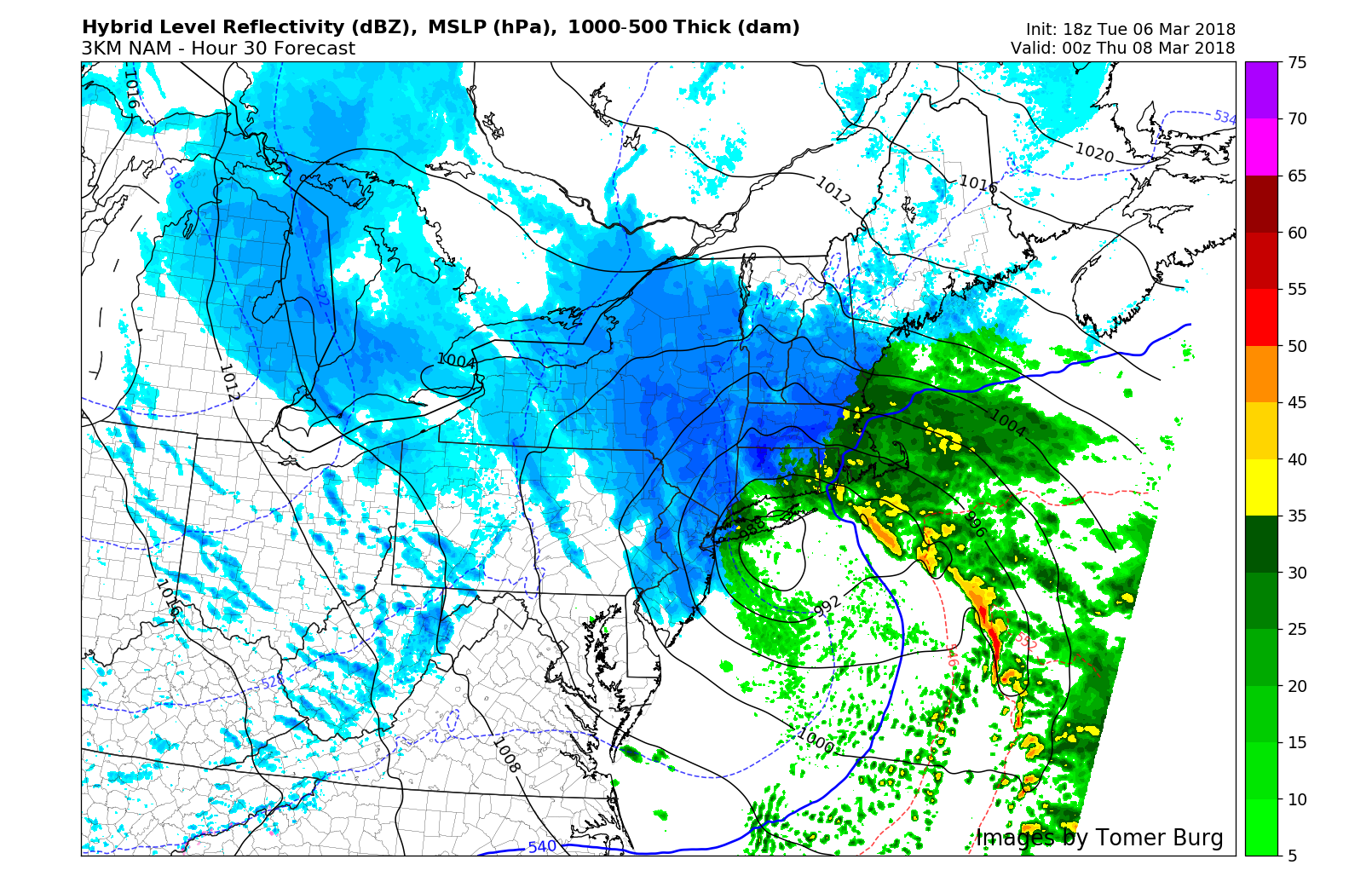
Tuesday’s 18z 3km NAM model valid for 7:00pm on Wednesday evening shows a “wraparound” band of snow pivoting across the area, even changing some coastal areas back over to snow (Tomer Burg).
Finally, during the mid to late evening hours, the system is expected to track northeastwards towards New England. As the system wraps up in the NYC and Long Island area, bands of snow will begin propagating towards New England and areas such as New Hampshire and Maine.
Uncertainties and Thoughts
The track of the system, as is most often the case, remains the main uncertainty. Forecast models have bounced back and forth between a west or east track with the storm – and in a relatively small envelope. In other words, tiny variations in the track of the system impact the overall evolution. These changes could impact where the gradient between snow/mixed precipitation sets up, how impactful a dry slot is, and where the heaviest bands are located. With that said, we are comfortable with our forecast moving forward – and will continue to monitor the latest data over the next several hours.
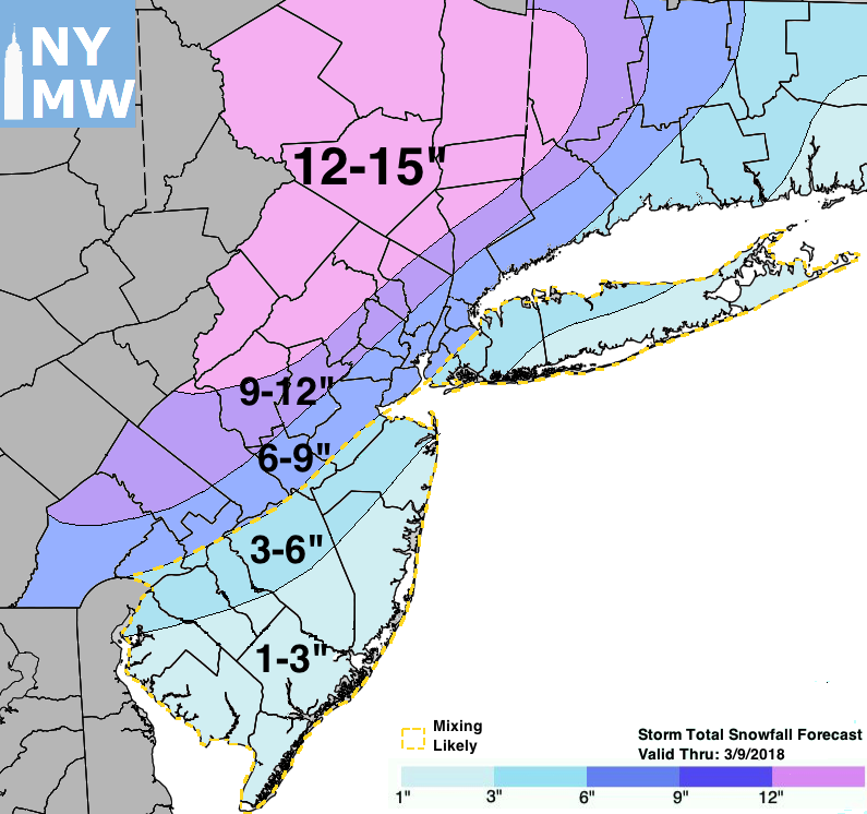
Storm Total Snowfall Forecast through March 9th, 2018.
Trackbacks & Pingbacks
2speakers
Comments are closed.