-2")
NYC Area Forecast: Calm weekend, another Nor’Easter Monday
[soundcloud url=”https://api.soundcloud.com/tracks/411620175″ params=”color=#d0e3ef&auto_play=false&hide_related=false&show_comments=true&show_user=true&show_reposts=false&show_teaser=true” width=”100%” height=”166″ iframe=”true” /]
Cloudy, cold and wintry weather has been the theme so far on this Saturday, and if you didn’t know it, you’d probably not guess that we were already through the first 10 days of March and well on our way to Spring. Instead, we’re sitting in a much colder than normal pattern, and this is expected to continue for the next several days. After two significant Nor’Easters, the development of a third looms on Monday.
Let’s get to the next few days first. Clouds this morning will break for sun as the day goes on (although this has been a bit delayed already). Temperatures are expected to rise into the mid 40’s in the city and a few degrees colder everywhere else, which is fairly typical for this time of year. The better of the two weekend days is expected to be Sunday, as dry high pressure keeps skies mostly sunny. This time of year, you’ll notice that even on “cold” days the sun feels warm – and you’re right, as the sun angle is changing toward warmer season.
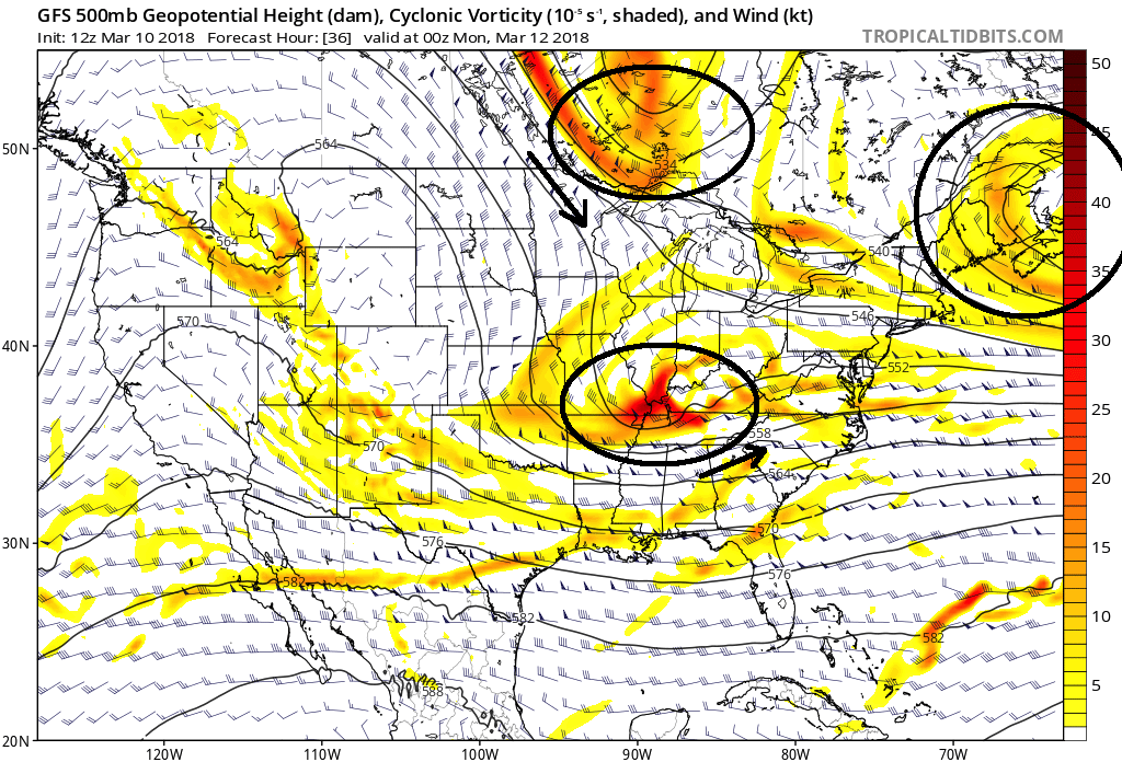
The three highlighted disturbances that are affecting the forecast of the potential Nor’Easter on Monday.
What’s going on with this potential storm on Monday?
This is what you’re here to read. Multiple disturbances in the atmosphere will interact and, together, aid in the development of a significant Nor’Easter on Monday. That much we know. There are three main disturbances at play. First, a disturbance that drives down into the Tennessee Valley this weekend. This one will situate itself towards the Southeast Coast by Sunday. Second, a large upper level low pressure spinning over the Northwest Atlantic. And third, a polar disturbance that surges south through the Great Lakes to “phase” with the initial disturbance over the Tennessee Valley.
Exactly how these disturbances interact, most importantly the polar disturbance and the Tennessee Valley disturbance, will impact the result in terms of sensible weather. Making matters worse is that forecast model guidance has struggled with the development, placement and timing of these important features, especially the Polar disturbance since it is emerging from a sparse data region. On the above graphic, we detailed the movement of the disturbances with arrows – so you can imagine how critical the track of the Polar disturbance will be.
A further west and aggressive track, and it will phase faster, leading to a more powerful storm that tracks close to the coast. This solution has popped up on a few weather models, but generally has remained the outlier (in other words, it’s possible, but not likely). If it takes a track further east and/or a little bit slower, the two disturbances will phase, but do so later, and the storm will have time to “slip” out to sea, with the most significant impacts either over Eastern New England or the open Atlantic Ocean.
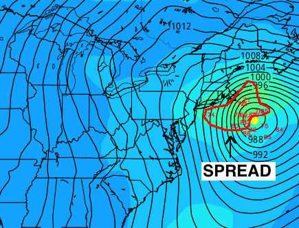
GFS Ensemble members with a highlighted spread to the west of the average track.
Most ensemble guidance as of the time of this post currently agrees that the seaward option is most likely. The ECMWF EPS and GFS Ensembles are heavily weighted offshore, with the cyclone development occurring several hundred miles east of Long Island and tracking well to the Southeast of Cape Cod. However, there are a few important things to note.
Firstly, there is a clear “spread” to the west when analyzing the ensemble mean (Average). This tells us that there is a notable group of ensemble members leaning closer to the coast with their tracks. You can see this highlighted in the graphic above — there are several members leaning to the left (or west/northwest) when compared to the average. In addition, the trend (or change in simulation over time for the same forecast time period) has been more amplified on several models, including the GFS and ECMWF.
This all suggests that we keep a very close eye on models through today. Despite the consensus for the storm to mostly miss the NYC Area to the east/southeast, the ensembles and overall trends suggest that we should not dismiss the possibility of more significant impacts just yet.
So, what is your forecast as of now?
With these trends and intricate interactions in mind, our forecast features lower confidence than normal moving forward. However, our forecast still carries the idea that the powerful Nor’Easter, while it develops, will mostly skirt to the east/southeast of the NYC region. The heaviest impacts appear more probable in Eastern New England and potentially Central and Eastern Long Island, while areas back to the west could see fringe or skirting impacts. We are not comfortable issuing a snowfall forecast yet, but stay tuned through tonight for the latest developments.
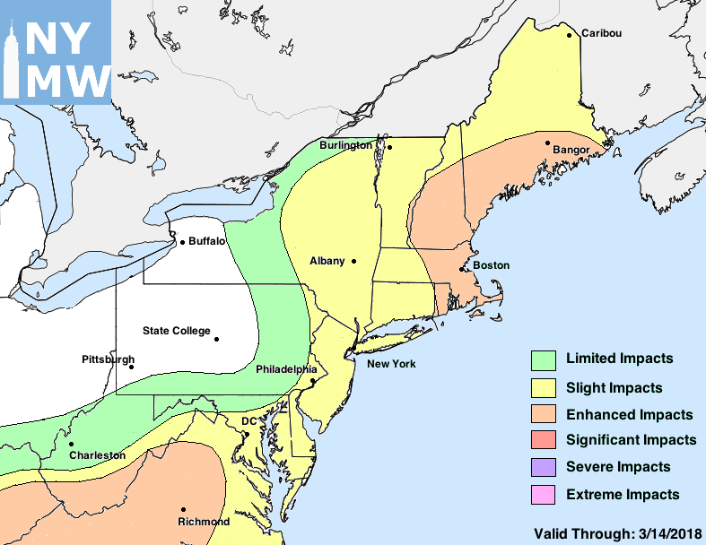
Our map below details our anticipated storm impact. Slight impacts are reserved for things such as slick roads, windy conditions, or light snow. Moderate impacts generally are meant to describe some travel delays, snow accumulation, or impactful/unusual conditions. Significant impacts are reserved for significant snowfall accumulations and/or widespread or unusual weather that will heavily impact day to day activities. This is a beta version of a simplified impact map. It is not meant to be used for operational forecasting decisions.
Trackbacks & Pingbacks
2arrives
Comments are closed.