-2")
Nor’Easter set to impact the area today, worst east of NYC
[soundcloud url=”https://api.soundcloud.com/tracks/412811202″ params=”color=#d0e3ef&auto_play=false&hide_related=false&show_comments=true&show_user=true&show_reposts=false&show_teaser=true” width=”100%” height=”166″ iframe=”true” /]
Quick Links: Northeast US Impact Map | Snowfall Forecast Map
Another significant Nor’Easter is set to impact the Northeast states on Tuesday – this time with the worst of the storm passing well east of NYC and impacting Eastern New England.
The third Nor’Easter in as many weeks (well, technically just over two weeks) is set to impact the Northeast states on Tuesday, bringing widespread impacts from just east of New York City into Long Island and all of New England. This storm’s formation was well underway this morning and it is expected to continue to strengthen through Tuesday morning and afternoon across the Northeast States.
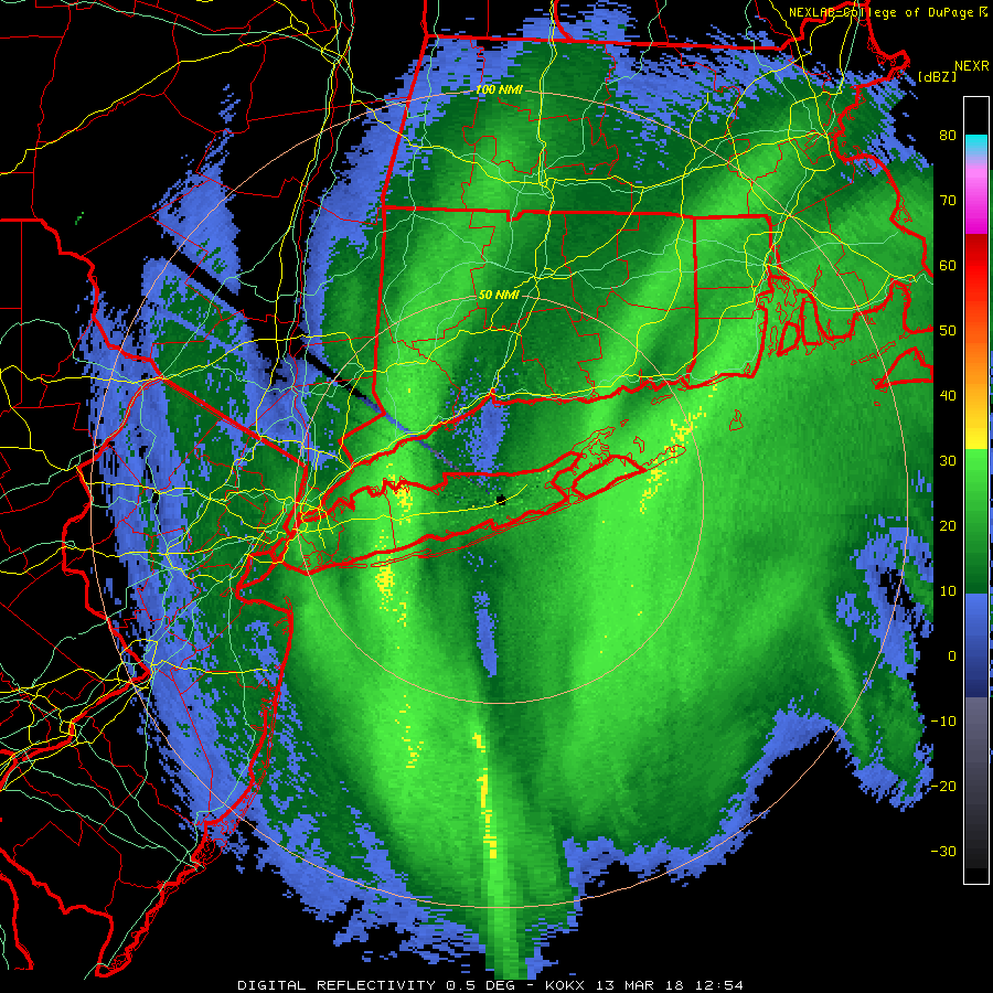
9:00am Tuesday Update: Heaviest banding has shifted east into parts of Long Island and Connecticut, where 700mb frontogenesis has increased over past few hours, with the storm tracking well offshore, as was previously anticipated. Current radar shows actually shows two frontogenetic bands of snow with some subsidence in between over Central Suffolk county and central parts of Connecticut. But these bands will likely merge before finally shifting east by early this afternoon.
Heavy snowfall rates of 1″ to 2″ per hour and perhaps even higher with reduced visibilities may for hazardous driving over next few hours. Snowfall totals over parts of Long Island and CT have been 2″ to 5″. These totals will likely double later this morning, especially over Suffolk County and New London County in CT. Although roads may not receive as much accumulation with surface temperatures between 32 to 34 F.
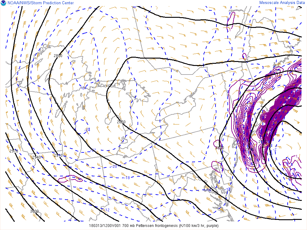
Current SPC mesoscale analysis , showing strong 700mb frontogenesis over Long Island and Connecticut.
Elsewhere, over most of New Jersey and the Lower Hudson Valley and Eastern PA snow appears to be winding down. A small moderate band has build back over NYC and extending into the ocean. This should shift east during the next hour. Snow will taper off to snow showers everywhere by around noon. Snowfall totals will likely wind up between 2″ to 5″. Although many paved surfaces, including roads, especially in NYC will likely receive less accumulation, with temperatures now in the mid 30s.
-Miguel Pierre
7:00am Tuesday Update: Snow is spreading throughout New Jersey and New York this morning, with light accumulations in many suburbs. Snow is much less likely to stick in New York City proper with warmer ground and pavement temperatures. This light snow will continue for the next few hours before beginning to pull back toward the east, with heavier bands developing towards Long Island and Connecticut.
The difference between this storm system and the past few will largely be the area it will impact. It otherwise parallels the other two storms very closely; it is powerful, rapidly intensifying, extremely dynamic, and will bring a myriad of impacts to the area it affects. The area most strongly affected with this one, however, will be Eastern New England and Long Island, where heavy snowfall and strong winds are likely.
Forecast models are struggling to pin down the areas where the heaviest banding will set up. In this storms case, banding is most easily delineated by locating areas of “Frontogenesis” or temperature gradients in the atmosphere that lead to enhanced lift for precipitation to form. We shorten this as “Fgen” in the meteorological world (big words are cumbersome to type, yes there was pun intended there). In the graphic below, you’ll see an illustration of where forecast models are depicting the best fgen bands to be.
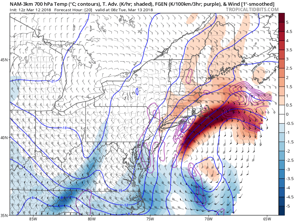
Loop showing frontogenesis banding on Tuesday via the NAM model.
Within these bands, moderate to heavy snowfall is expected, as strong lift in the atmosphere promotes heavy precipitation. But outside of them, sinking air is often observed, with much lighter precipitation rate. It’s these bands that can be the make or break in a meteorologists forecast – and forecast models are jumping around with exactly where they will set up. Our gut has pushed a bit east, and we have adjusted our forecast accordingly, with the best bands over Eastern Long Island and Eastern New England.
Here’s how we expect the storm to shake down:
This morning
As the storm system develops, the low pressure center will still be located over the Mid Atlantic coast. However, moisture associated with the developing storm will slide northward along a frontal boundary, enhanced by an upper level jet streak. Fancy talk for the fact that snow will begin across parts of NJ and LI, possibly even in NYC. It is expected to be relatively light in nature. With that being said, cold temperatures overnight could lead to light accumulations on area roadways. This will be especially true over Eastern NJ and Long Island overnight.
Tuesday Morning
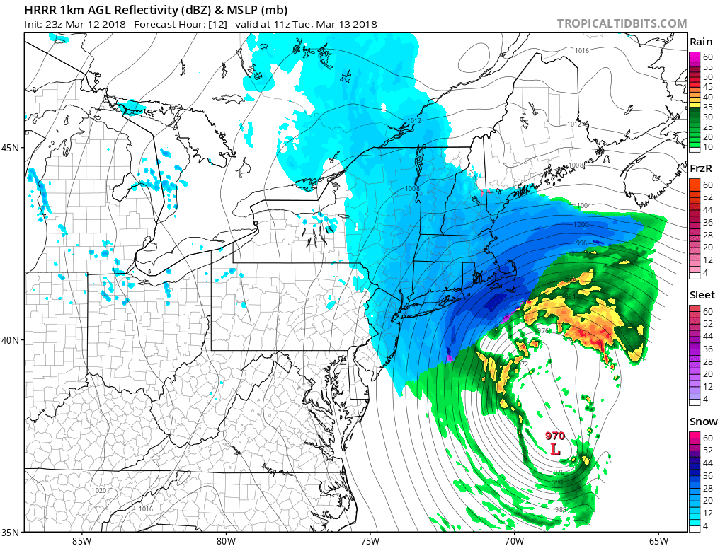
HRRR model showing snow in the Northeast on Tuesday morning, with the heaviest snow clearly over Eastern New England.
Bands of snow will remain quite light over New York City and New Jersey. The focus during this time period will begin to turn toward Central and Eastern Long Island, where bands of moderate to occasionally heavy snow will fall. These bands will shift northward into Connecticut and spread through Southern New England as well. Areas further west, like New York City and New Jersey, will see light snow, but any accumulations will remain negligible.
We recommend leaving extra time for travel on Tuesday morning regardless of your location, but especially if you live on Long Island or in Central and Eastern Connecticut and Southern New England. If you live in Eastern New England, just don’t travel on Tuesday at all.
Tuesday Evening
Precipitation will begin wrapping up from west to east, with any snow over NJ and NYC ending. Long Island will see the back edge of banding from the storm system continuing into the evening hours on Tuesday. Meanwhile, the system will hit its stride in New England, with very heavy snow bands pivoting through Eastern Connecticut, Rhode Island, Massachusetts, New Hampshire and Coastal Maine. Strong winds and waves will lead to a myriad of impacts in those areas, including (obviously) wind damage and the potential for coastal flooding. The system itself will slow, but linger into Tuesday Night in those areas before wrapping up and exiting by Wednesday morning.
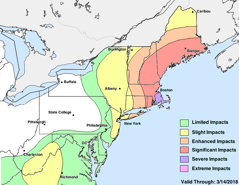
Our Final Impact Map for the upcoming storm system.
Accumulations and Impacts
Our accumulation and impact map is included below. We hedged towards a further west solution, but not one that includes any significant impacts for NYC proper. Impacts will be much less once one travels west of there into NJ. Central and Eastern Long Island are likely to receive a borderline-plowable snowfall, while areas in Connecticut and Southern New England are in for a significant winter storm.
The storms maximum impact will come in Southeast Massachusetts, where heavy wet snow and strong wind gusts will combine to lead to “Severe” impacts, which we characterize as severely impactful and/or unusual weather that will cause a significant disruption to daily life including widespread travel impacts and the potential for property damage. Our snowfall forecast for the local NYC area is included below as well.
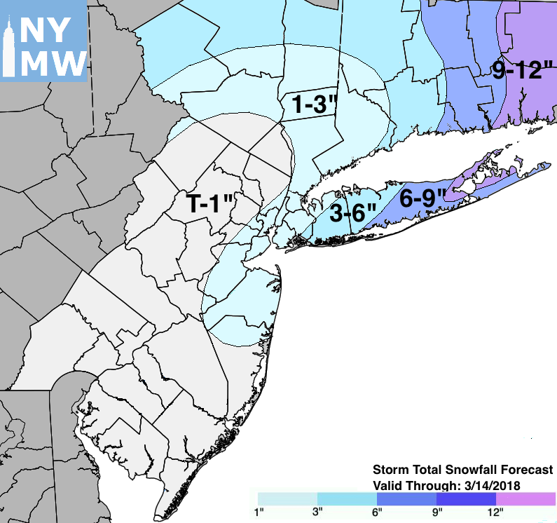
Our Storm Total Snowfall Forecast through Wednesday.
Trackbacks & Pingbacks
3undermine
Comments are closed.