-2")
Weekend Update: Watching another potential snowstorm next week
Good morning! We’ve updated our running weekend post to chat further about the weather over the next few days. Calm and pleasant conditions are in place this morning, with temperatures very cold and anomalously cold for this time of year. It will remain cold throughout the day, and through the remainder of the weekend. We’re carefully watching the potential for another significant winter storm during the middle part of next week, but the plot has thickened as model guidance is now not as keen on the storms development.
Cool and Dry Weekend Ahead
Saturday looks to start off rather clear and cold across much of the Northeast as the northwesterly flow remains intact. An area of mid level energy will quickly pass to the north and east during the day, possibly allowing for some high level clouds to move over the area during the afternoon hours, but the vast majority of tomorrow should be quite sunny. As we move into the afternoon hours, a decaying piece of mid level energy will pass to the south of the Northeast, leaving much of the area dry. This shortwave will only be capable of dragging a surface cold front through the area as we move later in the day, leaving cold and breezy conditions in its wake. Saturday night will be quite cold, as the surface cold front clears the east. Surface temperatures tomorrow night will drop well into the 20’s once again, with some locations to the north and west of the NYC area possibly seeing lows in the teens!
Sunday will be another very cold morning, but should begin to gradually warm up throughout the day as ridging to our west begins to strengthen. Conditions should stay clear and cool throughout the day, with temperatures likely making it into the lower 40’s for the immediate NYC metro area. Some readings in the middle to upper 40’s are likely to the south over portions of southern New Jersey towards the afternoon hours. Lows will be cold once again Sunday night as cold air creeps back into the Northeast, with readings likely hovering at or just above freezing for most of the NYC metro.
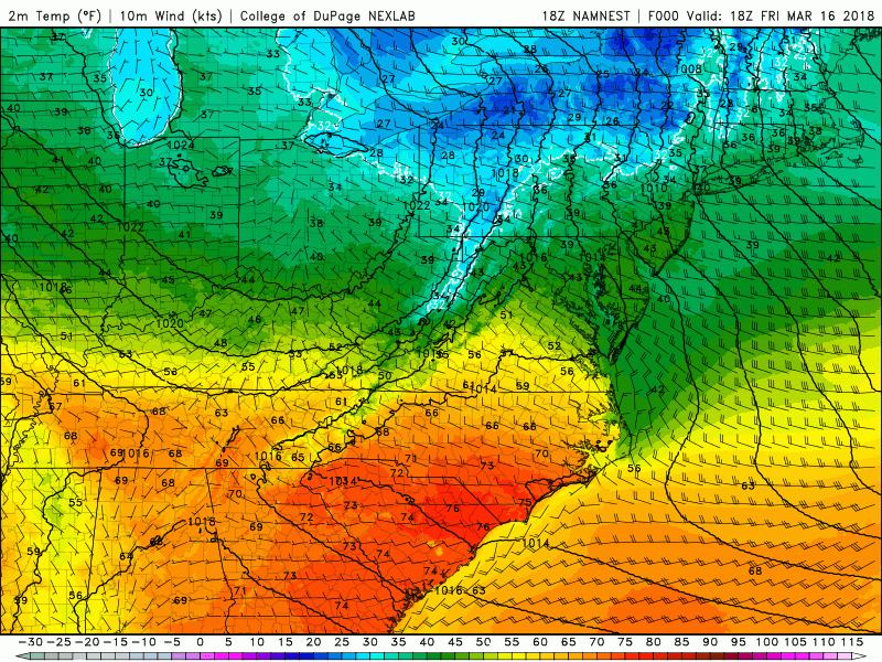
This afternoons high resolution NAM model showing the evolution of colder temperatures this weekend over the Northeast
Watching Next Weeks Potential Snowstorm
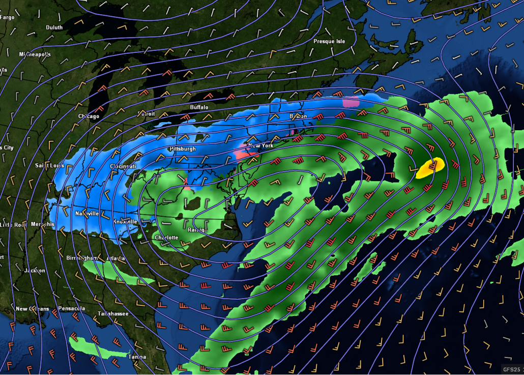
After a series of impressive cyclones along the East during the first half of March, it appears likely that there will be another system to impact the Mid Atlantic/Northeast again starting on Tuesday. This system starts off as a closed upper level system over the Plains that heads east during the Saturday/Sunday time period. Precipitation will likely break out across most of the South on Monday, with the threat of some severe weather likely over the Tennessee Valley due to a strong amount of moisture flowing north out of the Gulf of Mexico while the low is over Arkansas. What’s keeping this low from simply cutting into the Great Lakes is a strong mid level block to the north of the system, forcing it on a easterly trajectory initially. Uncertainty grows substantially on Monday with the overall evolution of this system, as it continues to move east/northeast underneath the block. This afternoons computer model guidance has shown a wide variety of solutions, with some models hinting at a snowstorm for the NYC area, and others showing virtually nothing. At this time, it is still too early to make any definitive calls about this system, but a blend of all of the available guidance reveals that there is the potential for this upper level system to track over the Tennessee valley and produce a secondary surface low pressure system off of the Mid Atlantic coast by Tuesday morning. Where this low pressure tracks will be highly dependent on the strength of the parent upper level system as well as the strength of the blocking (confluence) to the north.
If the system is weak and the confluence is too strong, then the secondary low pressure system will likely just drift east off the coast and provide very minimal impacts for the NYC area. This is a solution that the European model and many of its ensembles have shown this afternoon. However, if the parent system is organized and the blocking to the north isn’t too strong, then its possible we could see the secondary low develop close to the coast and provide some more substantial impacts, like this afternoons GFS model advertises. It also looks like this system will likely come in two parts-the first part is whats called “overrunning precipitation”, which is from the parent low pressure system as it decays. The next part would be from the developing secondary/coastal low, if it does develop close enough to the coast.
Overall, the threat for a snowstorm is there during for early next week, but there a quite a few uncertainties that need to be hammered out over the next couple of days. For now, a blend of models appears to the best way to go, and keeping in mind the aforementioned key items (strength of parent system and blocking to the north)
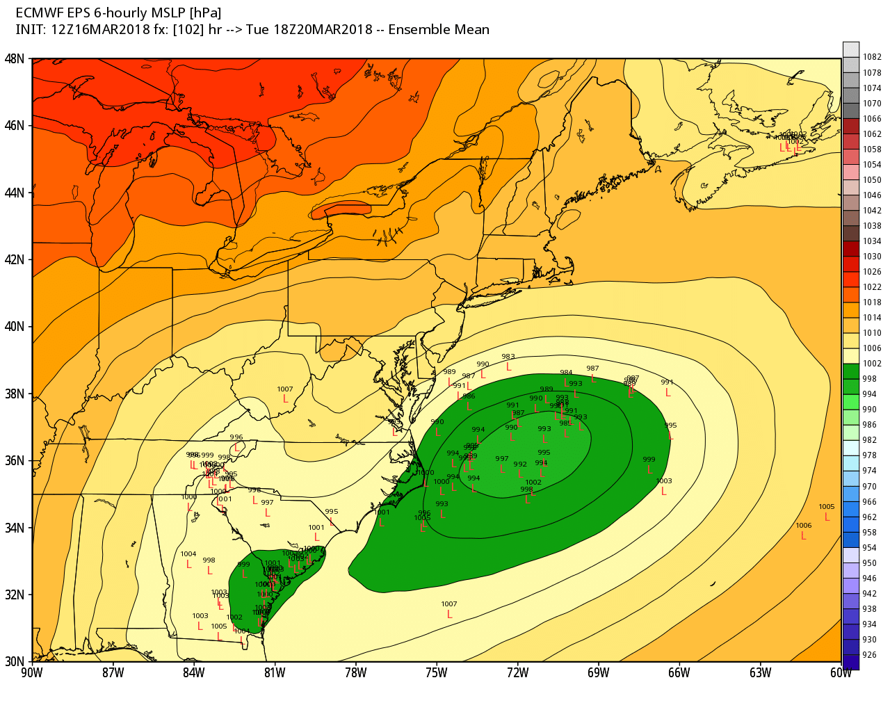
This afternoons European ensembles showing a considerable amount of spread among its members
Have a great weekend!
Steve Copertino
Trackbacks & Pingbacks
3attempting
Comments are closed.