-2")
Unsettled Weather into Saturday, Snowstorm Threat Decreases
Good morning! It’s been very active since the first week of March, with high-latitude blocking and anomalously cold air resulting in late season snowstorms for the Northeast states. April 2018 will wind up being one of the snowiest for many of the local climatology sites. However, it appears that we might be getting a break (finally) with the next few storm systems this weekend and early next week developing over the Eastern US.
First for today, a low pressure area tracking over the Great Lakes will cause a warm front to move through this afternoon. Some lift from mid-level warm-air advection ahead of the front, has caused light precipitation to form over the local region this morning. Temperatures rising into the upper 30s to lower 40s with southeast winds have supported mostly rain over New York City, Long Island, Southern NJ and other coastal areas – while temperatures still in the lower to middle 30s in areas further inland has supported light snow. But as temperatures continue to rise, snow will likely mix with or change to some rain before ending by early this afternoon. Overall we are not expecting precipitation to be anymore than a nuisance for parts of the region, as most roads should remain wet and temperatures continue to rise.
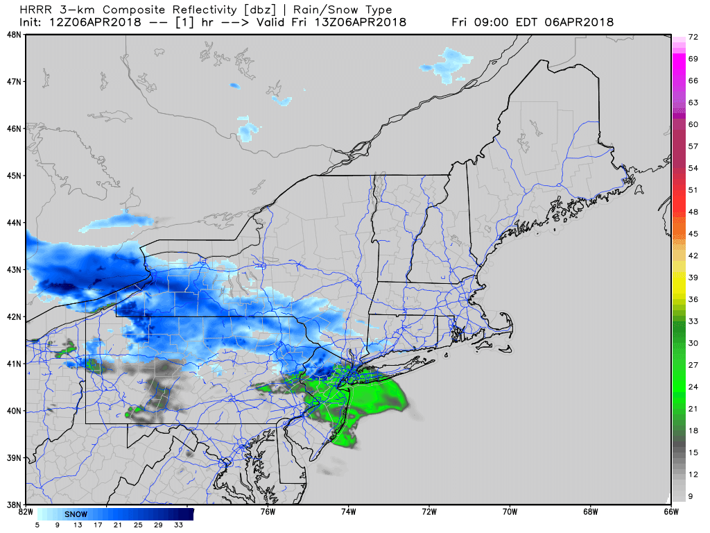
HRRR model showing snow and rain moving north of the region this afternoon, then more showers arriving tonight with a cold front
Winds will become more southwesterly this afternoon, as the warm front lifts northward. These winds will help temperatures to rise into at least the lower to middle 50s. But if clouds also break for some sunshine, temperatures will rise into the upper 50s to lower 60s, especially over Southeast Pennsylvania and Southern New Jersey, where the warm front is likely to move through earlier.
A cold front will slowly come through the region early tonight. A strengthening upper-level jet streak will enhance showery activity along and just behind this cold front. As it turns colder, rain showers may change to snow showers late tonight or early Saturday morning, especially over the Interior. But little or no accumulations are expected with temperatures still likely above freezing.
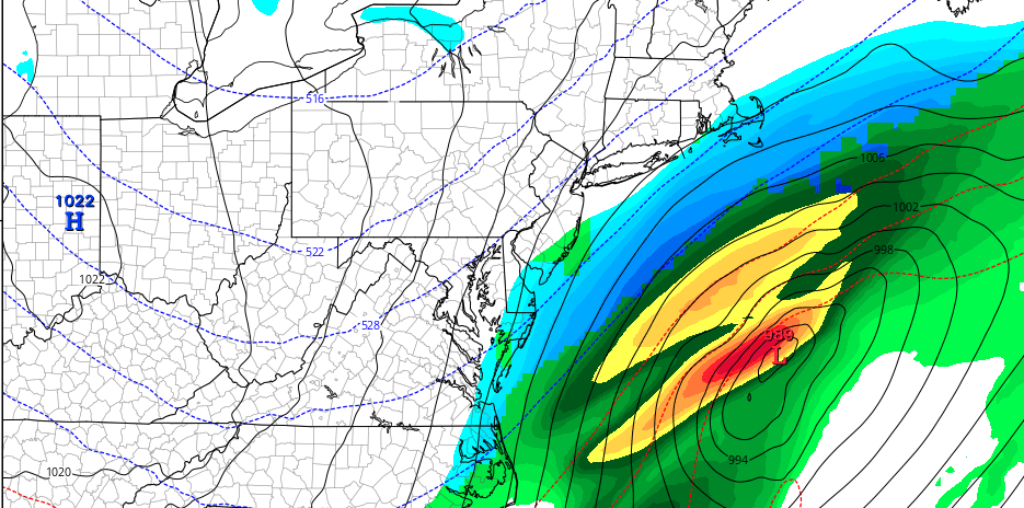
Earlier this week, the model and ensemble guidance indicated a wave of low pressure developing along the cold front would track further north, giving the tri-state region moderate or significant snowfall, as some colder air returns this weekend. This was largely dependent on more interaction or phasing between northern and southern stream energy along an upper-level trough. Instead, guidance now indicates the energy will remain more separated, as the flow will be more progressive with a faster pacific jet. Therefore, the chances for another late season snowstorm have decreased significantly for this weekend in the local region.
Any rain or snow showers will taper off during the morning hours on Saturday, as the cold front pushes further south. Clouds may actually break for some sunshine during the midday hours, especially northwest of New York City. Temperatures will be below normal again with highs in the mid-upper 40s. Then mostly cloudy skies are expected early Saturday night as low pressure to the south begins moving northeast out into the Atlantic. The outer fringes of the storm may still brush coastal areas with some light snowfall, but any impacts or hazards are expected to be minimal. Skies will clear late Saturday night with temperatures dropping into the lower to middle 30s over the region.
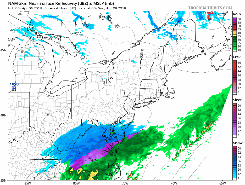
3km NAM showing this weekend storm skirting coastal areas with some light snowfall
High pressure from the Great Lakes builds into the Northeast providing mostly sunny skies on Sunday. High temperatures will be in the upper 40s to lower 50s, which is still below normal for this of year. Then another storm system will impact the region with light precipitation for parts of the region on Monday and Tuesday. A primary low will be tracking and weakening over the Ohio Valley, while a secondary low develops near the Mid-Atlantic coast. But colder air will be lacking and it appears the storm overall will consolidate too late for any significant precipitation.
Overall, the pattern is becoming more progressive with high-latitude blocking relaxing and a pacific jet extension over next two weeks. This means that it will be more difficult for storms systems and colder air to come together for more snowfall in the region- – as it should be for April. In fact, the latest ensemble guidance is indicating stronger ridging over the Eastern US with perhaps some warmer than normal temperatures by next weekend.
But don’t put away the coats, jackets or sweaters yet! There may still some volatility with the pattern moving forward later this month. Some of the latest ECMWF ensembles and weeklies are indicating high-latitude blocking may actually reload the week after, causing below normal temperatures to return to the Northeast US. More updates to come over the next several days!
Trackbacks & Pingbacks
2husbandry
Comments are closed.