-2")

Backdoor cold front season is here, what’s the deal?
Note: This post has been edited from its original version and refreshed for Spring 2018.
Each spring we emerge from a long cold winter with aspirations of 70 degree temperatures, a cool breeze and plenty of sun. It rarely works out that way. Whether it be an upper level low, a stalled cold front, or a back door frontal boundary, there are plenty of meteorological events to blame for a cold and damp spring in the Northeast states. The fact of the matter is, the Northeast is a difficult place to be during a transition season. The changing and morphing wavelengths of the mid and upper level ridges and troughs mean the potential for cutoff lows, and the colder ocean waters(this time of year especially) will wreak havoc on any warmup.
This weekend, we will once again revisit the science behind a back door cold front. A significant low pressure system is developing through the Central United States today, with the severe weather likely from the Plains into the Mississippi Valley and Southeast states. Meteorology tells us that a warm front should be surging north from the Mid Atlantic states into New England as this low pressure moves towards the Great Lakes, with southerly winds ramping up warm air south of the front. But forecast models suggest the front will only progress so far before it begins a dramatic retreat back south. Why? The answer lies in the setup both aloft and at the surface, and it leads to the development of a backdoor front which will push the warm air back to our south late Saturday into Sunday.
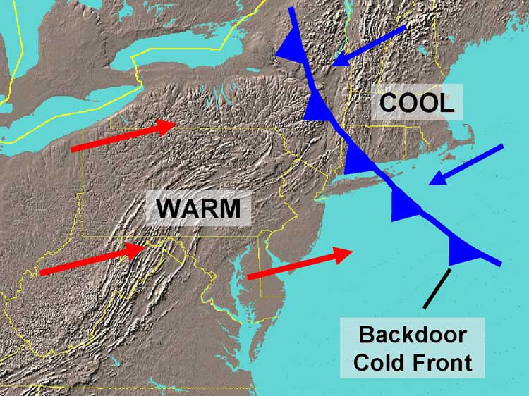
An illustration of a backdoor cold front, showing the colder marine air moving southwest from New England.
A glance at the atmospheric setup today shows us part of the reason why the frontal boundary will move southward this weekend. With a significant shortwave and disturbance in the mid levels over the Central US , the mid level heights out ahead of it begin to rise. In essence, a developing mid level ridge. In most cases, as discussed above, this would be the first sign of warmer weather to come for our area — in the warm sector ahead of a cold front. But upon further inspection, it’s not hard to see the mid level trough which is hanging around to the north of Northern New England. This compresses the mid level ridge axis which is developing ahead of the Central US storm system, and keeps colder air to our north.
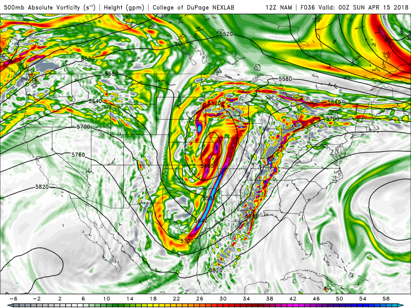
The NAM model showing a large trough over Central Plains and ridge over the Eastern US. Another trough north of Northern New England, compresses the ridge, thus allowing high pressure to nose into Central New England with onshore winds.
At the surface, a high pressure system develops on the periphery of the mid level ridge. But with the troughing to our north over New England, the high pressure noses its way down into Central New England. The flow around this high pressure turns the wind direction east/northeasterly — and that is bad news for everybody. The cold, marine air over New England and essentially from the Gulf of Maine to the Northwest Atlantic then has the ability to surge southward into the Northern Mid Atlantic states. Meanwhile, the warm front strengthens over the Mid-Atlantic but cannot make a push northward due to the compressed surface and mid level flow to its north.
We can see this exact feature on today’s forecast models. The backdoor front comes roaring back southward on Saturday evening, even after an initial warmup, and the northeasterly flow brings drizzle, damp air, and temperatures in the upper 30’s and lower 40’s back into New England and the Northern Mid Atlantic. The unusually cold airmass to our north is making things even worse than they normally would be.
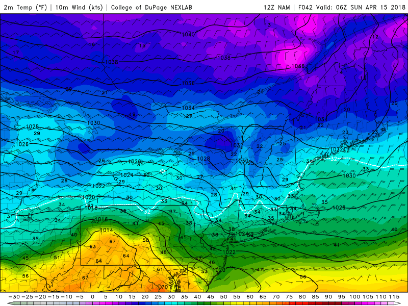
The NAM model showing much colder temperatures over the region Saturday night with the backdoor cold front to the south
As the season draws on, the warm air tends to gain traction — and the colder ocean waters will have less of an influence as they inevitably warm up as well. Plenty of times later this spring and into the summer, the Mid Atlantic and Northeast will benefit from changing wavelengths and troughs which are forced much farther north, therefore leading to thermal boundaries moving north as well. This often keeps the backdoor cold fronts over far northern New England, while most areas are able to sit under the warm sun.
For now, we’ll have to deal with the raw and cool conditions knowing that warm air is just a few hundred miles to our south. It’s a painful tease in the Springtime dance towards Summer.
Trackbacks & Pingbacks
3actuality
Comments are closed.