-2")
Cool & Unsettled Early Week, Summer-Like Warmth Mid-Late Week
Happy Sunday! On Saturday afternoon and night, a cold front associated with an upper-level low came through the region with some showers and thunderstorms in the local region. This cold front has since moved well offshore with some clearing today. But some cooler and unsettled weather is likely, for the next couple days, as the upper-level low and begins to cut-off and slow down over the Northeast. Then a major warm up with more summer-like temperatures is still expected during the middle to later part of this week. We discuss more details for the forecast for this coming up!
For the rest of this Sunday afternoon, clouds will continue to mix with more sunshine at times. Some instability under the cut-off low could cause some widely scattered showers could pop up later this afternoon, especially over parts of the Hudson Valley and New England. But very little rainfall is likely, with lift and moisture very limited. High temperatures will be in the mid-upper 50s over most of the region. Any showers will taper off early this evening, with loss of instability from daytime heating. Skies will be clear to partly cloudy for most of tonight with low temperatures in the upper 30s to lower 40s across the region.
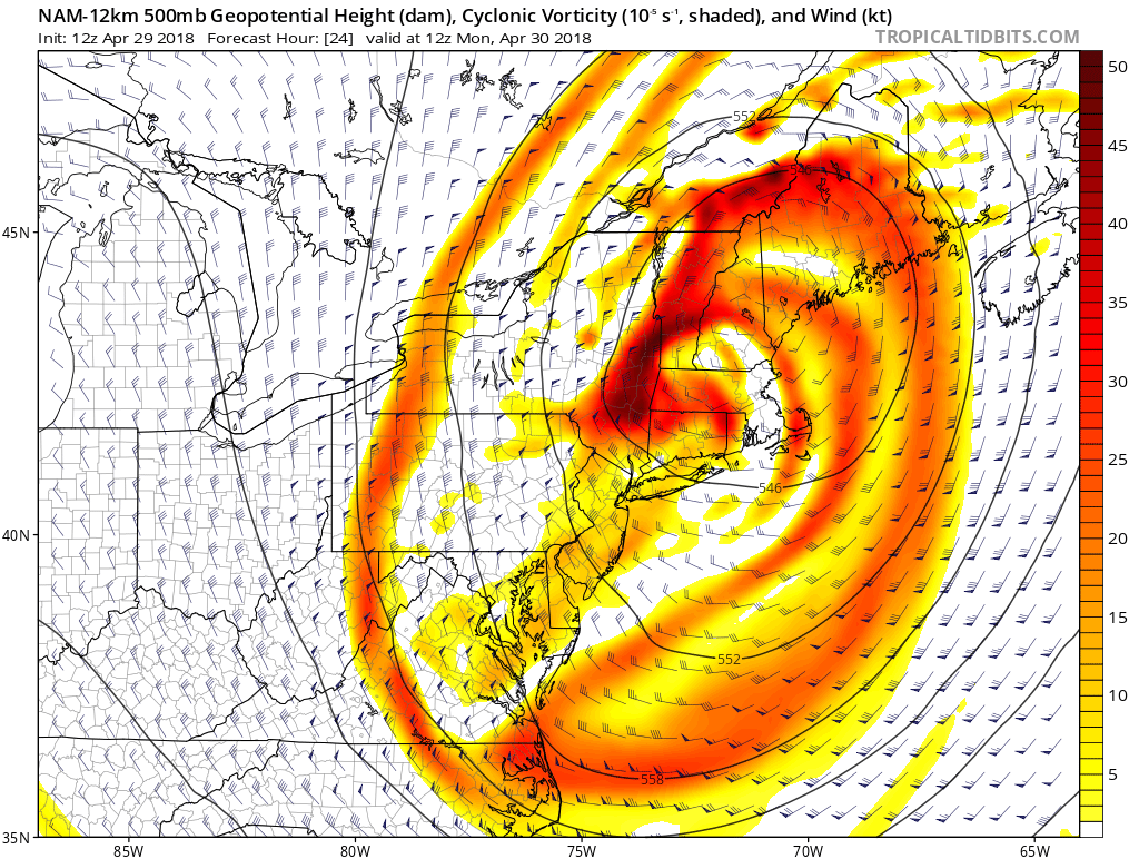
NAM model showing cut-off low over the Northeast early Monday morning.
On Monday, some strong shortwave energy will be swinging southward on backside of this cut-off low. This will likely result in a little more cloudiness and showers during the day, over parts of the region. This may keep high temperatures only in the lower to middle 50s, especially over Northern New Jersey, and Connecticut. While other areas further south and west, such as Eastern Pennsylvania and Central to Southern New Jersey may get more sunshine, to help temperatures warm up into the upper 50s to lower 60s. Further north, over the Lower Hudson Valley and parts of New England, the airmass may actually be cold enough to support some wet snow showers, early in the day.
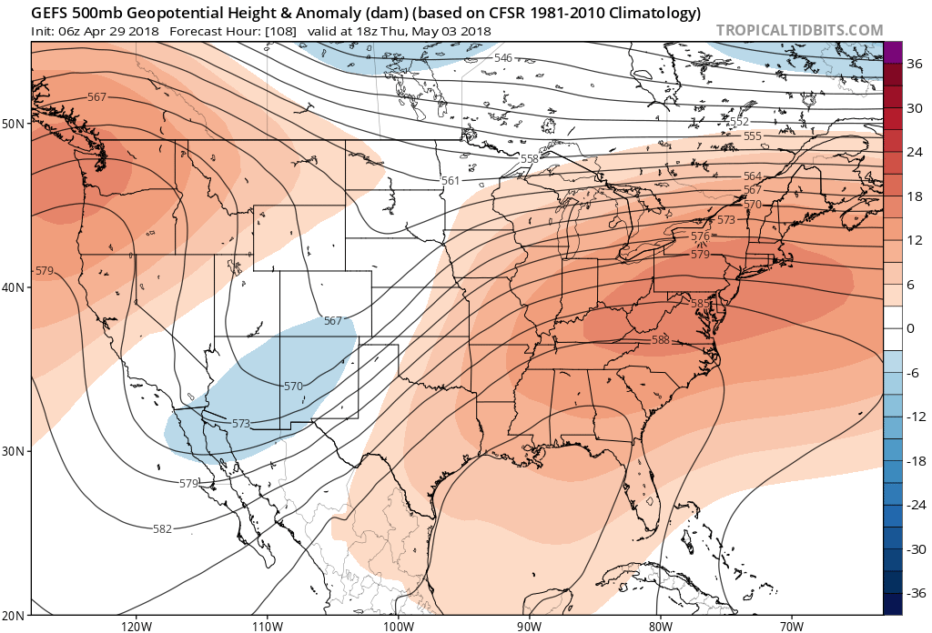
Then a deep trough moving out the Western US will begin causing a strong ridge to build further east over most of Eastern US, for the rest of this week. This will force the cut-off low to move further east into the Atlantic. Then a Bermuda high with a southwest winds will finally usher in a much warmer airmass into the Northeast. Temperatures will start warming up on nto the 70s, on Tuesday with more sunshine, during the day. During Wednesday, Thursday, and Friday temperatures will be in the 80s over much of the region.. Some spots may even approach 90 degrees by Friday. Closer to shore, sea-breezes will likely keep temperatures a little cooler. But still it will feel like early summer around here and humidity won’t be high.
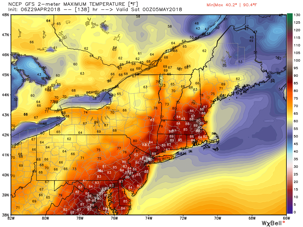
GFS model showing temperatures in the upper 80s to near 90 along parts of the I-95 corridor from Washington DC to Boston by Friday
A couple of disturbances will be moving along the northern periphery of the ridge, during the midweek period. But any shower or thunderstorm chances will be very limited until the end of the week or during next weekend, when another strong cold front will begin approaching from the west. Some warmer than normal temperatures may still continue into the weekend, before the cold front arrives. But another cooler airmass will likely arrive in the the Northeast by the following week, as the upper-level trough associated with the cold front, breaks down the ridge over the Eastern US. Temperatures may fall back to near or just below seasonable levels, behind the front.
Overall we anticipate some volatile weather to continue over next few weeks. This is due to the MJO propagating through phases 8/1/2, resulting in more tropical forcing with some ridging returning over the Western United States and Canada. However, if the MJO continues to propagate into phases 3/4/5, we may see more riding return during the later half of May, Some of analogs for used in our summer forecast preview issued, including May 1962, supported more ridging with warmer temperatures during the last two weeks of May as well. Stay tuned for more details on the long-range pattern for May.
Trackbacks & Pingbacks
1contiguous
Comments are closed.