-2")
Weekend Outlook: Heat Builds in the Northeast
For seven straight weekends now, we have discussed the possibility of showers, cooler than normal weather, and unsettled conditions. This weekend will finally buck the trend. Warmer, benign weather with plenty of sunshine is expected for the entire weekend in the Northeast states as high pressure settles in. As time goes on, temperatures will increase thanks to a building mid-level ridge.
On Saturday, temperatures will begin warming up with highs in the mid-upper 80s. By Sunday, high temperatures are expected to reach 90 degrees or higher, as southwest winds usher in increasingly warm and humid air. The heat will likely peak on Monday, as 850mb temperatures between 20°C to 22°C expand to encompass much of New England. There is potential for high temperatures in the mid to upper 90s and Heat Index values near or over 100°F in the urban corridor.
In fact, the National Weather Service is suggesting the potential for record breaking heat. High temperature forecasts on Monday are in the mid to upper 90s, which in many locations would top the prior record temperatures (largely in the lower 90s for the date). The potential for an official heat wave (3 days with temperatures of 90 F or higher) does exist, but uncertainty remains in regards to the timing of a cold front shifting southward on Tuesday.
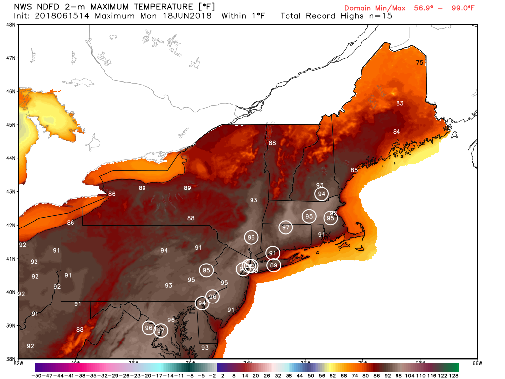
National Weather Service forecasting some record highs over the urban corridor in the Northeast on Monday
This heat will come as a shock to the system after several weeks of near normal or below normal temperatures. Just this week, temperatures remained largely below normal for this time of year. The large ridges in the mid levels of the atmosphere, which often feature the biggest heat, have struggled to move into the Northeast states so far this summer, a pattern we suggested would occur when we issued our Summer Forecast.
Still, this first ridge expansion into our region isn’t expected to be the last. There should be numerous “brief” bursts of heat over the next few weeks as this ridge, mostly centered in the Central United States, pulses up and down. In between, temperatures will likely cool off quite a bit – resulting in a “roller coaster” type feel to the weather pattern.
With these fluctuating ridges will also come the opportunity for some thunderstorms. As such, we are monitoring the potential for just that from later Monday into Tuesday. While no official designated risk area has been issued yet by the Storm Prediction Center, it appears probable that the aforementioned cold front will sink south near the region during that time frame. Thunderstorms appear distinctly possible on Monday, particularly in New England, and again on Tuesday as the front sinks south toward the Mid-Atlantic. While timing and kinematics (shear and forcing) will be crucial for significant or widespread severe weather, it appears instability will likely be sufficient for at least few thunderstorms to become strong or severe.
We’ll have more on the ebbs and flows of the pattern in the coming days.
Trackbacks & Pingbacks
1reactions
Comments are closed.