-2")
NYC Area Forecast: Some Unsettled Weather This Weekend
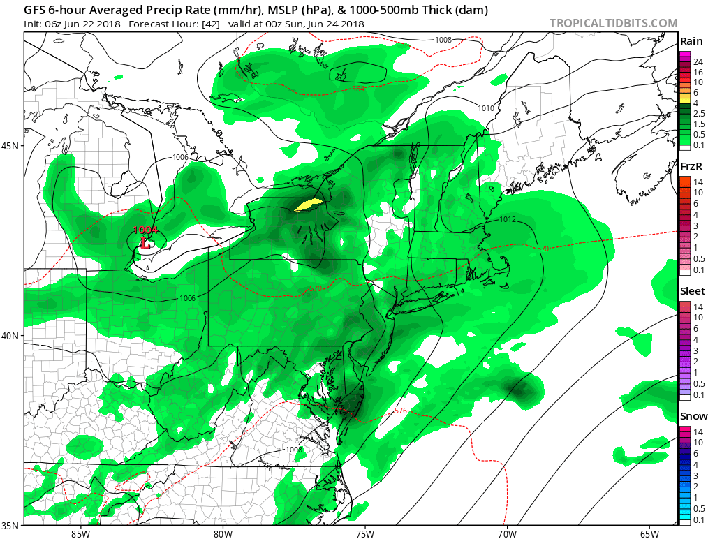
Good morning! A closed upper-level low over the Midwest will track through the Ohio River Valley and Great Lakes region through this weekend. This low will open up and weaken into a broader trough as it runs into additional confluence over the Northeast US. As a result, we aren’t expecting a washout with widespread or heavy rainfall for either day of the weekend. But this storm system will certainly cause some unsettled weather at times, especially for Saturday.
Friday and the Weekend
For today, clouds and sunshine will be variable throughout the day, as a warm front begins moving slowly northward over the Mid-Atlantic region. More cloud cover will tend to be just south and west of NYC metro. While more sunshine wins out over the Hudson Valley and Connecticut with stronger high pressure to the northeast. But onshore easterly winds, will also support a maritime airmass over the region. Thus high temperatures will likely be in the mid-upper 70s, over much the region, which is just slightly below average for this time of year.
Some scattered showers, may begin arriving this afternoon or this evening, especially over parts of Eastern PA and New Jersey. But with high pressure slow to depart over Northern New England today, will more likely cause many of these showers to fall apart before reaching NYC metro and other areas further north and east. Thus any rainfall through this evening, is expected to be on the lighter side.
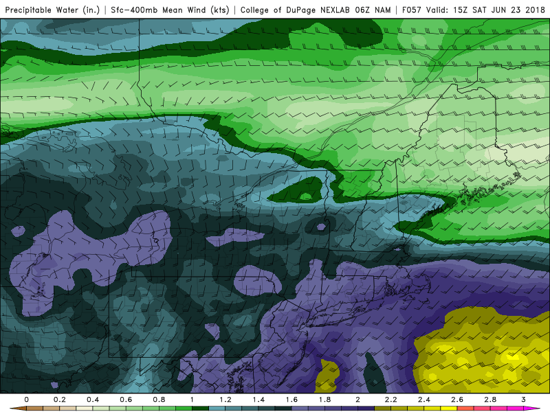
But later tonight and Saturday morning, as high pressure moves off the New England coast and the warm front continues lifting slowly northward, isentropic lift and elevated instability will be increasing. Thus more scattered showers and thunderstorms with some heavy downpours, are more likely be over parts of the region. Sub-tropical moisture streaming along this front with precipitable water values around 1.50″ and higher may support some locally heavy rainfall totals.
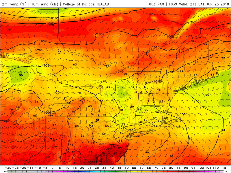
NAM model showing a wide range of temperatures from to north to south over the Northern Mid-Atlantic region, with a warm front stalling out over Central NJ, late Saturday afternoon.
There will likely be lull in the rainfall, during the late morning or early to mid afternoon hours on Saturday, as the best lift and instability shifts further north of the region. But weak of wave of low pressure will develop along the warm front and act to keep this front south of NYC metro with clouds and onshore winds remaining in place into the afternoon and evening hours. As a result, a wide range of temperatures between 60s to 80s is now likely north to south across the region on Saturday.
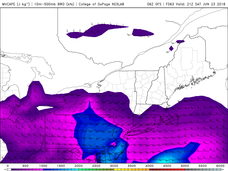
We will also have to monitor potential for some isolated strong to severe thunderstorms in the warm sector, particularly over parts of the Mid-Atlantic region, later Saturday afternoon and evening. Although weak mid-level lapse rates may mitigate this threat, shortwave energy associated with the storm will interact with at least some moderate levels of instability and shear. Overall Saturday is not looking pretty.
However by Sunday morning, the warm front should finally lift northward through the entire region. This will cause skies to clear for some sunshien during the midday hours, with increasing southwest flow. Temperatures are likely to rise into the mid-upper 80s, with humidity increasing as well. Overall, Sunday may turn out to be decent for most outdoor activities. But a cold front associated with another shortwave trough coming out the Great Lakes, will be approaching later in the day. With some instability building, be prepared for a possibly a few more scattered showers and thunderstorms during the late afternoon or evening hours.
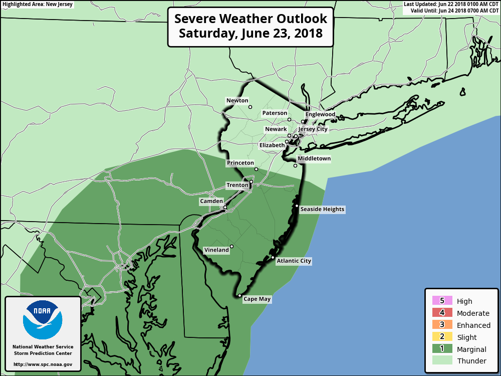
The Storm Prediction Center’s latest outlook with a marginal risk of some isolated strong and severe thunderstorms over the Mid-Atlantic coastal region Saturday afternoon and evening.
Next Week and Beyond
The aforementioned cold front will be through later Sunday night. Behind it, Canadian high pressure is now expected to build into the Northeast, providing more pleasant, sunny weather with cooler and less humid conditions to start the work week. High temperatures will be closer to average, in the upper 70s to lower 80s.
Then as high pressure slides of the Mid-Atlantic region, more return southerly flow will allow for warmer and more humid conditions to return on Wednesday and Thursday. High temperatures may reach the mid-upper 80s. Another shortwave trough with a weak cold front may trigger some scattered showers and thunderstorms by Thursday afternoon and evening. But much cooler air is not likely return, as this trough will likely lift out the Northeast by next weekend.
In fact, it is looking increasingly likely late next week that more troughiness over the Western US will result in the expansion of ridging over the Central and Eastern US. This will support heat and humidity to returning to the Ohio River Valley and the Northeast US at the end of this month and or during the first week of July. This is also supported by model and ensemble guidance forecasts for the MJO to propagate into the phases 2/3 during this time frame. More updates come to soon!
Trackbacks & Pingbacks
3quarrelsome
Comments are closed.