-2")
Behind the intricacies of the incoming heat wave
It is not often that we can confidently state “A heat wave is coming” so many days in advance, yet here we are.
A heat wave is coming.
Granted, it hasn’t been easy pinning down the details of this pattern. But forecast model guidance has largely pointed most meteorologists in the right direction when it comes to this upcoming bout of heat. A combination of tropical forcing signals and the wave pattern in the North Pacific Ocean helped tip the hand of the hemispheric evolution, one that signified the development of an anomalous ridge along the East Coast.
That ridge will, in fact, form as this work week goes on. It will come as a big change, especially when one takes the time to analyze the weather pattern currently in place, one that has featured cooler and wetter than normal conditions from the Ohio Valley to the Northeast and everywhere in between. Nevertheless, the changes are underway, and you’ll start to notice them as the week goes on.
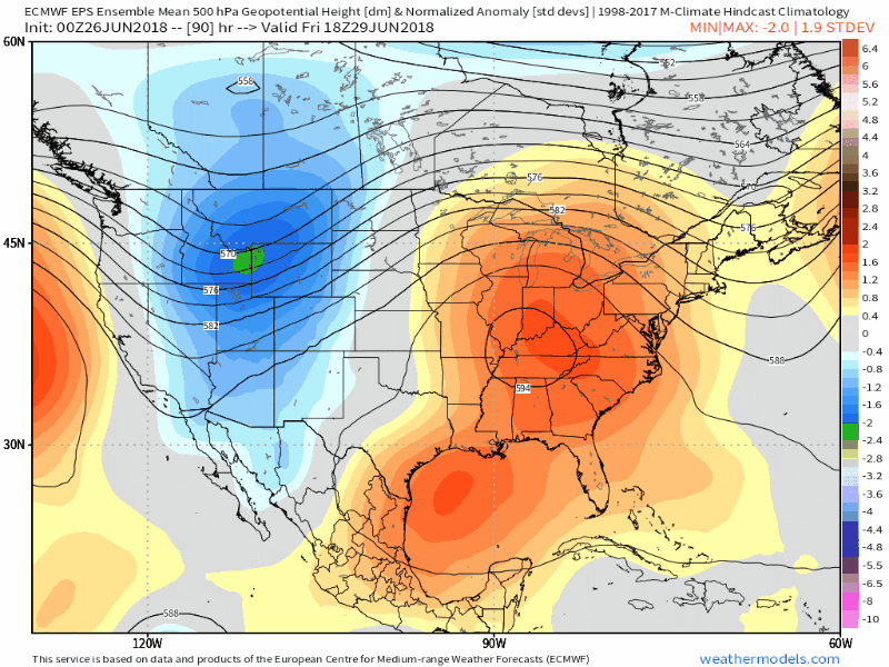
Rising heights in the mid and upper levels of the atmosphere will occur in tandem with an increasingly noteworthy southwesterly flow at the surface. In short, the advection of hot air from the Central/Southwestern USA will begin to occur. Temperatures will respond during the latter part of the week, with high temperatures in the Ohio Valley and Northeast States rising into the 90’s quite quickly.
As many of us know, however, there’s often more to these patterns than what meets the eye. This potential heat wave will be no different. We know there’s a heat wave on the way in the Northeast states, but how exactly will it behave? Heat waves are, in some ways, subsets of a larger weather pattern. They have, and are often remembered by, their own characteristics and behaviors.
Think of the heat wave in July of 2011 as an example. That was one of the first times I can ever remember feeling dry, desert air advecting into the Northeast states. West/northwest winds advected in 850mb temperatures of 25 C. The temperature skyrocketed over 103F in many locations with very low dew points and nary a cloud in the sky. A rare event for many of the Northeast states that lie directly next to a huge ocean.
As it stands now, this heat wave currently looks to be quite different from the famous dry heat of 2011 (2010 had a dry heat wave as well). In fact, forecast model guidance may already be tipping its hand that this heat wave will be nearly the opposite – characterized by heat-mitigating sea breezes. The secret to how heat waves behave and are characterized often lies in the details of the low level wind pattern.
We know that a large ridge is building overhead at 500mb – the middle of the atmosphere. But the low level atmospheric flow offers a much more complicated evolution. Forecast model guidance suggests the highest pressures and most anomalous mid level heights will actually surge to the north and west of the Northeast states. This will actually allow the low level flow to swing and “curl” around the highest pressures, resulting in a heightened chance of an easterly component to the wind. Instead of being directly within the west or northwest flow advection region of the wind, much of the Northeast could be in a more “modified” area.
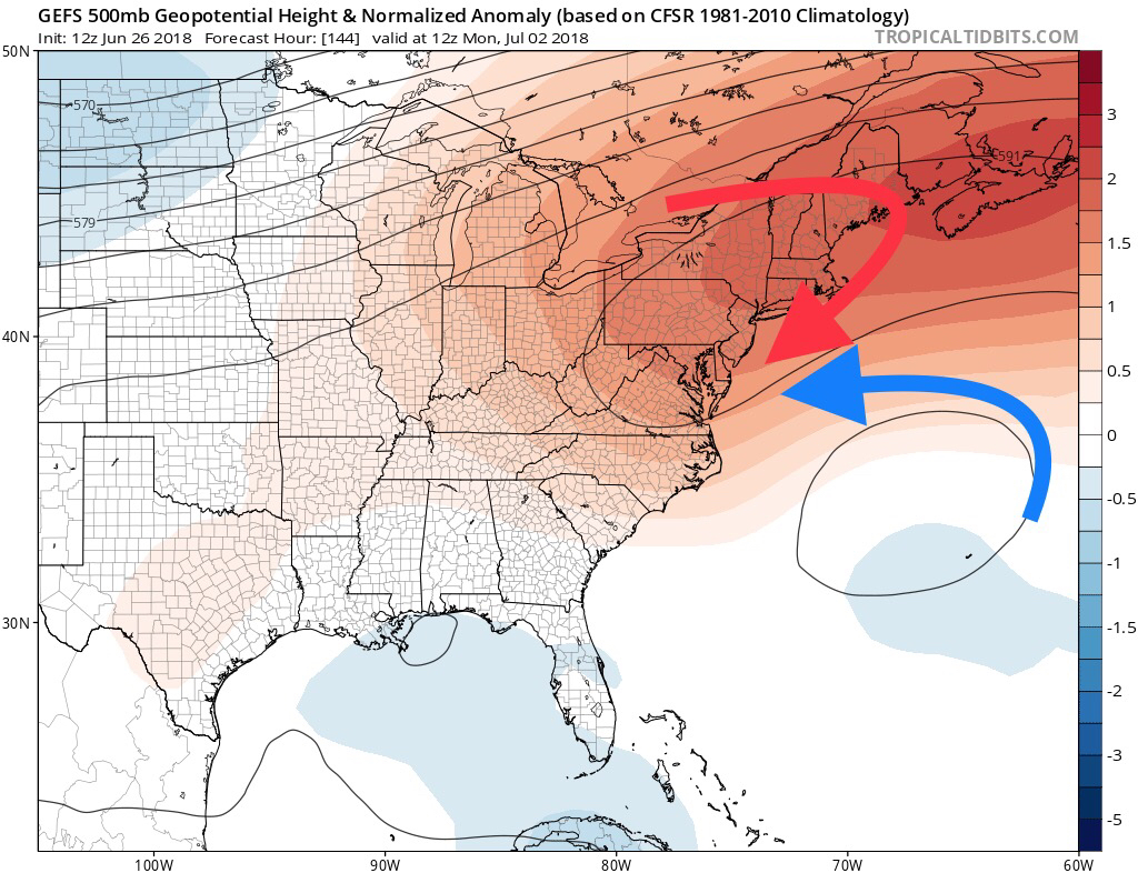
Adding even more intrigue is the potential for a weak area of lower pressures associated with some tropical moisture over the Western Atlantic, off the Mid-Atlantic coast. NHC has suggested a minimal chance of tropical development here, but that really isn’t what’s important. Tropical development or not, it appears possible that an area of disturbed weather will form here. This will further adjust the low level wind flow – now swinging counter clockwise around an area of relatively lower pressures.
The combination of the two factors above could lead to a light east/northeasterly wind component in the low levels of the atmosphere, despite a very anomalous ridge over the Northeast states aloft. This opens the door for cooler, marine influence along the coast and strong seabreezes pushing inland during the afternoon hours, dropping temperatures back to more reasonable levels and increasing dew points.
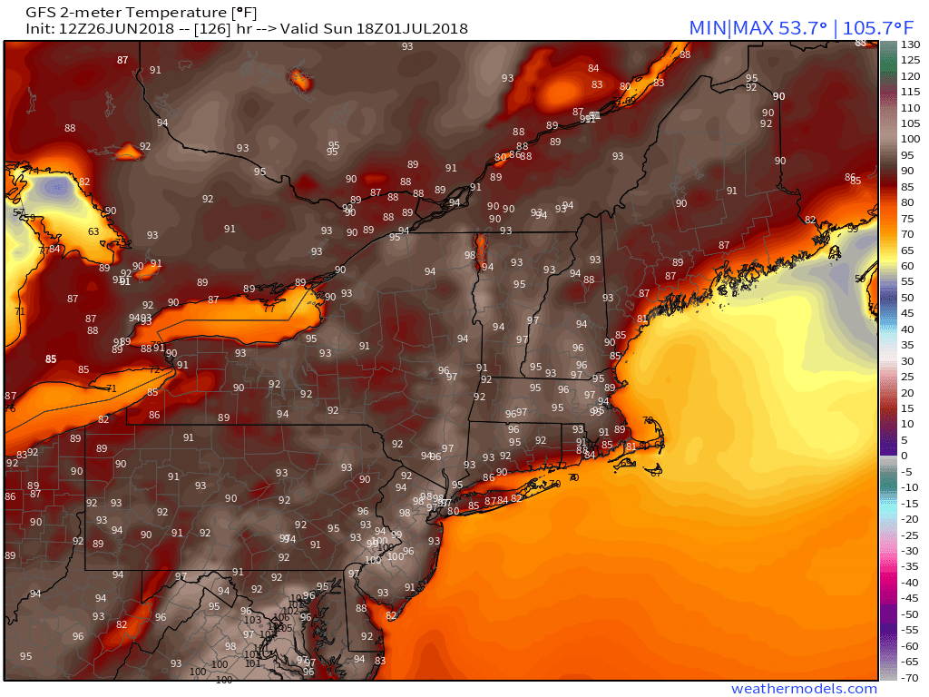
So we digress for a moment. A heat wave is still expected. Temperatures are still going to be very hot – well into the 90’s – in many areas of the Northeast, particularly in parts of the urban corridor when they may approach 100 F at times. But this specific heat wave’s defining characteristic may very well end up being the seabreezes it allows to form which will bring sweet, sweet relief during the sweltering hot afternoons.
Trackbacks & Pingbacks
2stating
Comments are closed.