-2")
Weekend Outlook: Warming Trend & Scattered T-Storms in the Northeast
Happy Friday! Overall a pretty decent summer weekend is on the way for outdoor plans, with just a little more heat and humidity. But there may some isolated or scattered showers and thunderstorm by Saturday night or Sunday, that you may take cover for briefly.
First for today, mostly sunny skies are expected, as high pressure remains in control. But it will begin shifting offshore, winds become more south-southeast. This will allow areas just inland to reach the middle to upper 80s, while areas near the coast remain a little cooler. A beautiful warm evening is on tap, then partly cloudy skies are expected overnight, as a warm front with some showers passes well to north of the region. Lows overnight will be in the upper 50s over the Interior to upper 60s or around 70 over urban areas.
On Saturday, partly sunny skies are expected, as the warm front passes north region. High temperatures will reach the mid-upper 80s. Then a weak cold front and shortwave associated an upper-level trough over passing over New England will begin approaching from the north this could trigger a few clusters of showers and thunderstorms over Interior parts of New York State and Pennsylvania later Saturday afternoon. Some isolated strong or severe thunderstorms with heavy rainfall and gusty winds are possible. These thunderstorms may congeal into a MCS (mesoscale convective system), rolling southeastward on top of ridging over the Mid-Atlantic region

3km NAM model showing a clusters of showers and strong thunderstorms over the Interior parts of the Northeast Saturday evening
But this MCS would likely weaken or fall apart before reaching New Jersey, New York City metro , Long Island and Connecticut during the evening hours, due to the weaker instability. Some more scattered showers and thunderstorms are later Saturday night into early Sunday morning, as cold front near the region and some instability increases with higher humidity. Main threat will be for some heavy downpours and frequent lightning. Otherwise, it will be partly cloudy Saturday night with temperatures dropping into the 60s over the suburbs and lower 70s over New York City and urban areas.
On Sunday, a mixture of sunshine and clouds is expected, as the cold front will continue moving southward through Southern New England and Northern Mid-Atlantic region.. But it will be weakening and will only serve to cause winds to shift to more west-northwest downslope direction. This will cause high temperatures to reach the upper 80s to lower 90s, throughout much of the urban I-95 corridor in the Northeast on Sunday. A few isolated or widely-scattered showers and thunderstorm may still pop up during the afternoon and evening, as instability builds during the afternoon. A few of these thunderstorms may also become strong or severe with some heavy rainfall, frequent lightning and gusty winds.
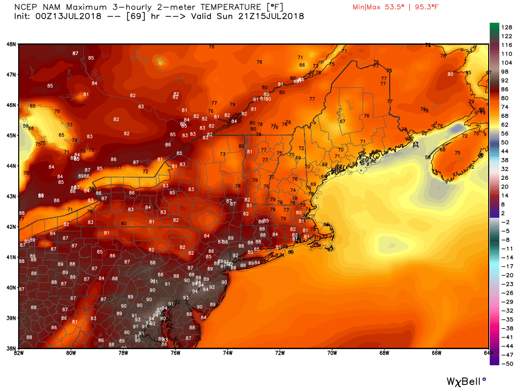
NAM model forecast high temperatures in the Northeast on Sunday
It will be hot and humid to start next week, as mid-upper level ridging building behind this weekend’s trough. More sunshine is expected on Monday. But on Tuesday, clouds are likely to increase, with a better chance of more showers and thunderstorms by the afternoon or evening hours, as a larger frontal system and upper-level trough moves to the East Coast. Subtropical moisture with very high precipitable water values will be streaming northward with a southerly flow ahead of this system, so there is potential for some heavy rainfall and flash flooding with training thunderstorms. Some stronger shear and modest instability may also support some more organized strong or severe thunderstorms, especially over Interior parts of Northeast.
So enjoy the weekend, whether you are hiking over the interior valleys or hanging out near the shore. Just be on the lookout for a few showers and thunderstorms later in the weekend. Check back for more updates on our social media channels for any strong or severe thunderstorms, around the Northeast this weekend. Our weekly planner blog post with a forecast update for next week’s weather, will come on Monday.
Trackbacks & Pingbacks
2thirty-one
Comments are closed.