-2")
Northeast US Weekly Planner: Humidity & Storms Return This Week
Good morning! Have you noticed the cooler and drier air in place? Great! Are you enjoying it? Even better! Because it won’t be around for long.
The first several days of August, in particular, look to bring a sharp return to mid-summer conditions in the Northeast, with increasingly prevalent moisture and humidity. Temperatures will warm gradually as well, with a tropical-like feel to the airmass that looks likely to continue into the middle of August at minimum.
High pressure is weakening and sliding offshore from the Northeast states today. Sunshine and lower humidity is expected to persist through the afternoon, as drier air remains stout. Gradually, however, a southerly flow is expected to return. This will aid in an increase in humidity and clouds as the afternoon goes on, with high temperatures in the Northeast averaging in the lower to middle 80’s.
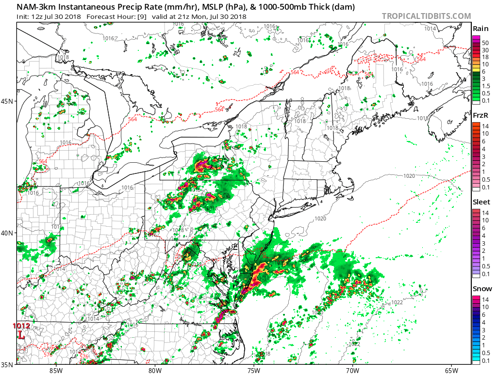
NAM model showing showers and t-storms arriving from the southwest over the Northern Mid-Atlantic region early this evening
Muggy weather makes its grand return on Monday night. It will become mostly cloudy, as a warm front to the southwest begins approaching. Temperatures will likely not fall below the lower 70s along the urban I-95 corridor and below the 60s over the suburbs, with more cloud cover and humidity. Some scattered showers may also arrive from the southwest this evening or later tonight, as lift and instability gradually increases from warm-air advection ahead of the warm front. Some patchy fog may also develop with light winds and low-level moisture increasing.
The increase in warmth and humidity continues on Tuesday. A weak wave of low pressure will develop along the tail end of the warm front, which is expected to be situated off the Southern NJ and Delaware shores. This low will likely act to keep the warm front from lifting further northward on Tuesday, so a mixture of clouds and sunshine is expected in the Northeast states, with an onshore easterly flow keeping high temperatures again in the lower to middle 80s. Some scattered showers or thunderstorms may develop during the afternoon hours, with increasing moisture and instability.
For the rest of the week into the upcoming weekend, the Northeast US will once again lie between the periphery of a strong ridge over the Western Atlantic and a large trough over the Ohio Valley. This pattern will keep a southerly flow in place, with a stream of tropical moisture over the Northeast US. The end result? More oppressive humidity, with high temperatures in the middle 80s to lower 90s and mixture of sunshine and clouds each day. At least some isolated showers and thunderstorms will be a threat by each afternoon and evening, with a very moist-unstable tropical airmass.
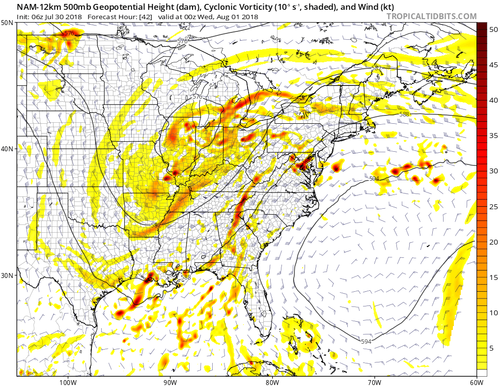
NAM model with large trough over the Ohio Valley and Strong ridge build over Western Atlantic on Tuesday evening
On Wednesday and Thursday, a mid-upper level shortwave and jet streak energy from a large trough will likely shift towards the Northeast and bring an associated frontal boundary along as well. This will result in more shear and forcing for numerous showers and thunderstorms. The biggest hazard from storms will be torrential downpours and localized flooding with very high precipitable water values. Unidirectional shear and flow parallel to the frontal boundary will also support showers and thunderstorms training in place, with over 2.00” of rainfall possible in some areas.
Despite high levels of CAPE and shear values, the warm tropical airmass with weak mid-level lapse rates will tend to limit the threat for high-end severe weather. Still, stronger wind fields and slightly drier mid-level temperatures may increase the threat for strong to severe thunderstorms, especially over Interior parts of the Northeast. Closer to the urban I-95 corridor or over the coastal plain, strong ridging may prevent widespread showers and thunderstorms with significant severe weather or heavy rainfall hazards on Wednesday and Thursday. This is our biggest uncertainty at this time.
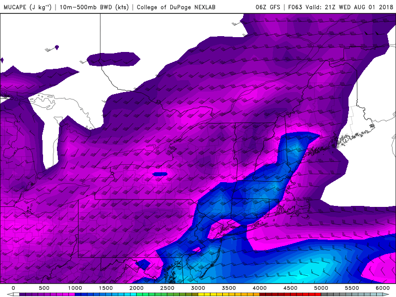
GFS model showing moderate instability with MUCAPE 1000> and 10m-500mb bulk shear for some strong to severe thunderstorms on Wednesday near and just northwest of the urban I-95 corridor in the Northeast
On Friday, the large trough from the Ohio Valley will weaken a bit, but also move further east, allowing for a more well-defined frontal boundary to move closer to the Northeast states. This suggests that showers and thunderstorms will become more common down to the urban I-95 corridor and coastal plain, with localized flash flooding a possibility. By this weekend, the trough should decay further, and allow more West Atlantic ridging to build in as a whole. Accordingly, we anticipate showers and thunderstorms will be more isolated in coverage again.
Overall, we expect the Western Atlantic Ridge will continue to flex its muscles over the next couple of weeks, as the MJO in phase 6 begins weakening and loses it strong influence on the atmospheric pattern over the entire country. After some cooler weather with a larger trough to close to the Northeast this month, additional ridging is expected with hotter and drier weather likely to return to the Western/Central Plains to start the month of August. The pattern will remain more active – albeit hot – across the Northeast US. Stay tuned for more updates on the forecast and pattern changes later this week!
Trackbacks & Pingbacks
1belgium
Comments are closed.