-2")

NWS confirms tornado in Queens
The National Weather Service has confirmed an EF0 tornado in Queens on Thursday evening, with winds of 85mph and a path of 0.7 miles.
A Tornado Warning was issued last night at 10:18pm by the National Weather Service, a few moments after strong rotation appeared on the Terminal Doppler Radar out of Kennedy Airport in Southern Queens.
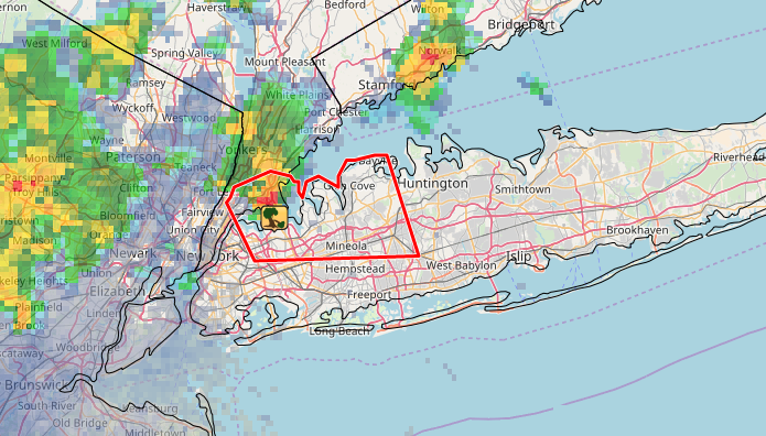
The tornado warning overlayed with radar imagery and location of damaging wind reports. Data via IEM.
The rotation tracked northeastward through Queens, with the strongest rotation occurring near College Point, NY. That’s where the National Weather Service chose to investigate this morning, and where they found damage consistent with that of a tornado. Damage was reported as early as moments after the Tornado Warning was issued on social media scanners and social media.
This was the first tornado warning issued in Queens since September 8th, 2012. There were additional Tornado Warning’s prior to that in 2011 and 2010.
Well organized couplet in a minisupercell. There was likely a tornado here. #nywx pic.twitter.com/XZu1HUZgRu
— John Homenuk (@jhomenuk) August 3, 2018
The media has come under some scrutiny for its handling of last nights events, as local news stations did not cut from regular programming until 10 minutes after the Tornado Warning was issued. Most residents were forced to turn to weather apps, social media, or local radar from various weather sources to make determinations themselves.
During tornadoes, time is of the essence. Meteorologists have worked tirelessly over the past few decades to improve tornado warning times by minutes to help save lives by giving people time to react. A delayed response from local news or media outlets to a critical weather event like a tornado warning could be catastrophic.
More information is expected to be made available soon regarding the tornadoes exact path, including photos of damage. We anticipate updating this article in the coming days.
Trackbacks & Pingbacks
1variants
Comments are closed.